Category:1990 maps of South Carolina
Jump to navigation
Jump to search
Media in category "1990 maps of South Carolina"
The following 4 files are in this category, out of 4 total.
-
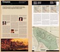
 Cowpens National Battlefield, South Carolina LOC 2007633873.jpg 5,459 × 4,812; 5.11 MB
-
 Cowpens National Battlefield, South Carolina LOC 2007633873.tif 5,459 × 4,812; 75.16 MB
-
 Cowpens National Battlefield, South Carolina LOC 98683594.jpg 5,499 × 4,803; 4.49 MB
-
 Cowpens National Battlefield, South Carolina LOC 98683594.tif 5,499 × 4,803; 75.56 MB

