Category:19th-century maps of Middlesex
Jump to navigation
Jump to search
Ceremonial counties of England: Bedfordshire · Berkshire · Buckinghamshire · Cambridgeshire · Cheshire · Cornwall · Derbyshire · Devon · Dorset · Durham · Essex · Gloucestershire · Greater London · Hampshire · Herefordshire · Hertfordshire · Isle of Wight · Kent · Lancashire · Leicestershire · Lincolnshire · Norfolk · Northamptonshire · Northumberland · Nottinghamshire · Oxfordshire · Rutland · Shropshire · Somerset · Staffordshire · Suffolk · Surrey · Warwickshire · Wiltshire · Worcestershire
City-counties:
Former historic counties: Cumberland · Huntingdonshire · Middlesex · Sussex · Westmorland · Yorkshire
Other former counties:
City-counties:
Former historic counties: Cumberland · Huntingdonshire · Middlesex · Sussex · Westmorland · Yorkshire
Other former counties:
Media in category "19th-century maps of Middlesex"
The following 5 files are in this category, out of 5 total.
-
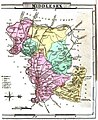
 Aikin(1800) p309 - Middlesex.jpg 1,936 × 1,179; 314 KB
-

-
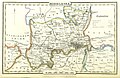
 Gray1824 middlesex.jpg 788 × 965; 132 KB
-

-
 Pigot and Co (1842) p1.360 - Map of Middlesex.jpg 2,070 × 1,345; 622 KB
_p309_-_Middlesex.jpg)
.jpg)

.jpg)
_p1.360_-_Map_of_Middlesex.jpg)