Category:6 - 15 Bold Place, Liverpool
Jump to navigation
Jump to search
| Object location | | View all coordinates using: OpenStreetMap |
|---|
building in Liverpool, Merseyside, UK  | |||||
| Upload media | |||||
| Instance of | |||||
|---|---|---|---|---|---|
| Location | Liverpool, Merseyside, North West England, England | ||||
| Heritage designation |
| ||||
 | |||||
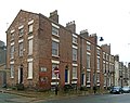
Grade II listed row of early 19th century houses on Bold Place next to St Luke's church.
Media in category "6 - 15 Bold Place, Liverpool"
The following 2 files are in this category, out of 2 total.
-
 6 - 15 Bold Place 1.jpg 4,397 × 3,478; 6.31 MB
-
 6 - 15 Bold Place 2.jpg 3,862 × 3,536; 5.86 MB
