Category:Bold Place, Liverpool
Jump to navigation
Jump to search
| Object location | | View all coordinates using: OpenStreetMap |
|---|
Bold Place runs by the side of St Luke's church between Berry Street and Roscoe Street, Liverpool.
Subcategories
This category has only the following subcategory.
6
- 6 - 15 Bold Place, Liverpool (2 F)
Media in category "Bold Place, Liverpool"
The following 6 files are in this category, out of 6 total.
-
 Benchmark at Bold Place, Liverpool.jpg 4,584 × 3,366; 7.47 MB
-
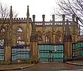 Bold Place gates to St Luke's.jpg 4,385 × 3,723; 8.11 MB
-
 Gate pier, front of St Luke's.jpg 3,640 × 4,912; 7.79 MB
-
 Post box, Bold Place.jpg 3,273 × 4,527; 9.25 MB
-
 Ropewalks, Liverpool L1, UK - panoramio (3).jpg 4,288 × 2,848; 6.24 MB
-
 View down Bold Place of gate piers and railings.jpg 3,623 × 3,645; 6.96 MB


.jpg)
