Category:Arthur's Pass (mountain pass)
Jump to navigation
Jump to search
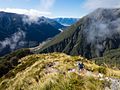
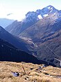
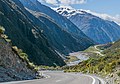
English: Arthur's Pass (el. 920 metres or 3,020 feet) is a mountain pass in the Southern Alps of the South Island of New Zealand. It marks part of the boundary between the West Coast and Canterbury regions, 140 km from Christchurch and 95 km from Greymouth. The pass lies in a saddle between the valleys of the Otira River, a tributary of the Taramakau, in the west and the Bealey River in the east. Arthur's Pass lies on the border of the Selwyn and Westland districts. A hamlet of the same name (Arthur's Pass) is located about 5 km south of the mountain pass.
mountain pass in New Zealand  Otira Viaduct west of Arthur's Pass | |||||
| Upload media | |||||
| Instance of |
| ||||
|---|---|---|---|---|---|
| Part of | |||||
| Named after | |||||
| Located in protected area | |||||
| Location |
| ||||
| Carries | |||||
| Mountain range | |||||
| Elevation above sea level |
| ||||
| Different from | |||||
 | |||||
Subcategories
This category has the following 2 subcategories, out of 2 total.
M
- Arthur's Pass memorial cairn (17 F)
O
- Otira Viaduct (28 F)
Media in category "Arthur's Pass (mountain pass)"
The following 21 files are in this category, out of 21 total.
-
 Arthur's Pass 911.JPG 5,472 × 3,648; 4.34 MB
-
 Arthur's Pass 913.JPG 5,472 × 3,648; 7.24 MB
-
 Arthur's Pass 915.JPG 5,472 × 3,648; 6.45 MB
-
 Arthur's Pass powerline.png 1,733 × 1,370; 1.93 MB
-
 ArthurPass-3.jpg 1,124 × 1,400; 732 KB
-
 ArthurPass-4.jpg 1,400 × 1,050; 721 KB
-
 Arthurs Pass - panoramio - Maksym Kozlenko (23).jpg 2,700 × 1,800; 1.78 MB
-
 Arthurs Pass - panoramio - Maksym Kozlenko (24).jpg 2,700 × 1,800; 1.46 MB
-
 Arthurs Pass - panoramio - Maksym Kozlenko (31).jpg 2,700 × 1,800; 1.27 MB
-
 Arthurs Pass - panoramio - Maksym Kozlenko (40).jpg 2,700 × 1,800; 1.43 MB
-
 Arthurs Pass - panoramio - Maksym Kozlenko (41).jpg 2,700 × 1,800; 1.48 MB
-
 Arthurs Pass - panoramio - Maksym Kozlenko (42).jpg 2,700 × 1,800; 1.43 MB
-
 ArthursPass.jpg 1,539 × 2,052; 930 KB
-
 ArthursPassBridge.JPG 1,488 × 1,984; 628 KB
-
 Brownings Pass or Arthur's Pass.jpg 1,080 × 1,518; 256 KB
-
 Icicles (20296056550).jpg 4,896 × 3,264; 5.92 MB
-
 NZ Arthur Pass 005 (17072895949).jpg 800 × 533; 98 KB
-
 NZ speeding SI.jpg 2,272 × 1,704; 1.41 MB
-
 Twin Creek MRD.jpg 4,032 × 3,024; 7.49 MB
-
 Valley of the Otira River.jpg 3,901 × 2,727; 8.34 MB
-
 Waiting for the road to open to Arthurs Pass - panoramio.jpg 1,880 × 2,816; 1.69 MB


.jpg)
.jpg)
.jpg)
.jpg)
.jpg)
.jpg)


.jpg)
.jpg)


