Category:Bata Park (Möhlin)
Jump to navigation
Jump to search
| Object location | | View all coordinates using: OpenStreetMap |
|---|
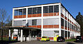
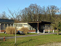
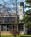
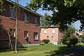
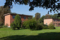
building complex in Möhlin in the canton of Aargau, Switzerland  | |||||
| Upload media | |||||
| Instance of |
| ||||
|---|---|---|---|---|---|
| Part of | |||||
| Location | Möhlin, Rheinfelden District, Aargau, Switzerland | ||||
| Street address |
| ||||
| Heritage designation | |||||
 | |||||
Media in category "Bata Park (Möhlin)"
The following 11 files are in this category, out of 11 total.
-
 Bata-Park in Möhlin (1).jpg 3,792 × 2,034; 2.29 MB
-
 Bata-Park in Möhlin (10).jpg 4,000 × 3,000; 4.51 MB
-
 Bata-Park in Möhlin (17).jpg 3,928 × 2,932; 4.95 MB
-
 Bata-Park in Möhlin (9).jpg 2,908 × 3,501; 4.53 MB
-
 ETH-BIB-Möhlin, Schuhfabrik Bata-LBS H1-018448.tif 6,882 × 4,786; 94.34 MB
-
 ETH-BIB-Möhlin, Schuhfabrik Bata-LBS H1-027614.tif 6,208 × 4,378; 77.8 MB
-
 ETH-BIB-Möhlin, Schuhfabrik Bata-LBS H1-027615.tif 6,150 × 4,292; 75.57 MB
-
 ETH-BIB-Möhlin, Schuhfabrik Bata-LBS H1-027616.tif 6,157 × 4,271; 75.28 MB
-
 Moehlin-Bata-Park-1.jpg 1,200 × 800; 1.29 MB
-
 Moehlin-Bata-Park-2.jpg 1,200 × 800; 1.31 MB
-
 Moehlin-Bata-Park-3.jpg 3,720 × 2,480; 8.42 MB
.jpg)
.jpg)
.jpg)
.jpg)

