Category:Bauernhaus, Herzwilstrasse 175
Jump to navigation
Jump to search
| Object location | | View all coordinates using: OpenStreetMap |
|---|
Deutsch: Schweizerisches Inventar der Kulturgüter von nationaler Bedeutung: Bauernhaus, Herzwilstrasse 175
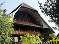
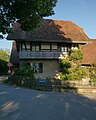
KGS Nr. 00988, Herzwilstrasse 175, 1777, Köniz (BE), 595.594 / 196.041, Kategorie: A, Objektart: Wohnbauten und ihre Nebenanlagen, Bauernhäuser.
rural building ensemble in Herzwil in the canton of Bern, Switzerland  | |||||
| Upload media | |||||
| Instance of | |||||
|---|---|---|---|---|---|
| Part of | |||||
| Location | Herzwil, Köniz, Bern-Mittelland administrative district, Bernese Mittelland administrative region, Bern, Switzerland | ||||
| Street address |
| ||||
| Heritage designation | |||||
| Inception | |||||
 | |||||
Media in category "Bauernhaus, Herzwilstrasse 175"
The following 10 files are in this category, out of 10 total.
-
 Bauernhaus Herzwil DSC05324.jpg 4,000 × 2,672; 3.6 MB
-
 Bauernhaus Herzwil DSC05326.jpg 3,323 × 2,492; 3.05 MB
-
 Bauernhaus Herzwil DSC05329.jpg 4,000 × 2,248; 2.96 MB
-
 Bauernhaus Herzwil DSC05330.jpg 4,000 × 2,248; 3.51 MB
-
 Bauernhaus Herzwil DSC05331.jpg 3,025 × 1,891; 1.98 MB
-
 Bauernhaus Herzwil DSC05332.jpg 4,000 × 2,248; 3.42 MB
-
 Bauernhaus Herzwil DSC05336.jpg 3,000 × 4,000; 4.27 MB
-
 Bauernhaus, Herzwilstrasse 175, Nordwestansicht.jpg 6,048 × 4,032; 9.2 MB
-
 Bauernhaus, Herzwilstrasse 175, Ostansicht.jpg 6,048 × 4,032; 11.29 MB
-
 Stöckli 1917, Herzwilstrasse 177, Ostansicht (cropped).jpg 3,226 × 4,032; 5.68 MB


.jpg)