Category:Bears (Friesland)
Jump to navigation
Jump to search
| Object location | | View all coordinates using: OpenStreetMap |
|---|
village in Friesland  _vlag.svg)   | |||||
| Upload media | |||||
| Instance of | |||||
|---|---|---|---|---|---|
| Location |
| ||||
| Population |
| ||||
 | |||||
English: Bears (Dutch: Beers) is a village in Littenseradiel, a municipality in the Dutch province of Friesland.
Frysk: Bears is in doarp yn Littenseradiel.
Nederlands: Bears (Nederlands, niet-officieel: Beers) is een dorp in de Friese gemeente Littenseradiel.
Subcategories
This category has the following 2 subcategories, out of 2 total.
B
S
- Sculptures in Bears (Friesland) (11 F)
Media in category "Bears (Friesland)"
The following 10 files are in this category, out of 10 total.
-
 Bears wapen.svg 404 × 459; 100 KB
-
 Map - NL - Littenseradiel - Wijk 04 - Buurt 02 Bears.svg 375 × 375; 49 KB
-
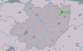 Map NL Littenseradiel Bears.png 800 × 500; 72 KB
-
 Beers (Friesland) vlag.svg 324 × 214; 4 KB
-
 20190515 Zicht op Bears1.jpg 4,985 × 3,325; 3.75 MB
-
 20190515 Zicht op Bears2.jpg 4,411 × 2,941; 2.27 MB
-
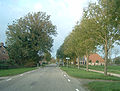
 2022 Bears, Bearsterdyk.jpg 3,384 × 2,253; 2.79 MB
-
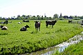
 2022 Bears, Jorwerter Feart.jpg 3,486 × 2,321; 3.55 MB
-
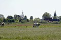
 2022 Bears, Op 'e Terp mei tsjerke.jpg 3,135 × 2,087; 2.83 MB
-
 Bears-Friesland.jpg 1,905 × 1,440; 513 KB


