Category:Beaverhead County, Montana
Bước tới điều hướng
Bước tới tìm kiếm
Counties of Montana: Beaverhead · Big Horn · Blaine · Broadwater · Carbon · Carter · Cascade · Chouteau · Custer · Daniels · Dawson · Deer Lodge · Fallon · Fergus · Flathead · Gallatin · Garfield · Glacier · Golden Valley · Granite · Hill · Jefferson · Judith Basin · Lake · Lewis and Clark · Liberty · Lincoln · Madison · McCone · Meagher · Mineral · Missoula · Musselshell · Park · Petroleum · Phillips · Pondera · Powder River · Powell · Prairie · Ravalli · Richland · Roosevelt · Rosebud · Sanders · Sheridan · Silver Bow · Stillwater · Sweet Grass · Teton · Toole · Treasure · Valley · Wheatland · Wibaux · Yellowstone
county in Montana, United States  Здание окружного суда в Диллоне, Монтана  | |||||
| Tải lên phương tiện | |||||
| Là một | |||||
|---|---|---|---|---|---|
| Được đặt tên theo |
| ||||
| Vị trí | Montana, Hoa Kỳ | ||||
| Trung tâm hành chính | |||||
| Ngày thành lập hoặc tạo ra |
| ||||
| Dân số |
| ||||
| Diện tích |
| ||||
| trang chủ chính thức | |||||
 | |||||
Thể loại con
Thể loại này có 17 thể loại con sau, trên tổng số 17 thể loại con.
Tập tin trong thể loại “Beaverhead County, Montana”
33 tập tin sau nằm trong thể loại này, trong tổng số 33 tập tin.
-
 Beaver Head county high.jpg 3.504×2.336; 3,63 MB
-
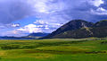
 Beaverhead Mountains.jpg 4.032×3.024; 3,74 MB
-
 Berry Meadow.jpg 2.848×1.602; 1,89 MB
-
 Brower's Spring August 2016.jpg 2.988×5.312; 6,87 MB
-

-
 Dillon Montana.jpg 720×540; 70 kB
-
 Eastern Pioneer Range MT.jpg 1.280×960; 105 kB
-
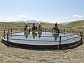 EQIP2 (23991954237).jpg 4.000×3.000; 4,89 MB
-
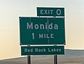 Exit 0 sign on I-15 north of Montana-Idaho state line.jpg 4.512×3.408; 7,82 MB
-
 Livestock1.JPG (38844618262).jpg 2.936×1.208; 1,27 MB
-
 Log Cabin Jump Maverick MT.jpg 1.280×960; 67 kB
-
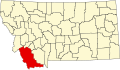 Map of Montana highlighting Beaverhead County.svg 9.194×5.303; 122 kB
-
 Monida, Montana.jpg 800×406; 32 kB
-
 Montana - Red Lodge through Twin Lakes - NARA - 23941959.jpg 4.385×3.382; 2,92 MB
-
 Montana - Red Lodge through Twin Lakes - NARA - 23941961.jpg 4.385×3.382; 3,42 MB
-
-

-
-

-
 MTMap-doton-Lima.PNG 300×175; 12 kB
-
 Near-horse-prairie-sw-montana-july-2010-roger-peterson-002 (5623243718).jpg 3.005×1.892; 1,5 MB
-

-
 Npnht-grasshopper-creek-bannack-montana-082011-rogermpeterson-001 (6819443180).jpg 4.288×2.848; 3,27 MB
-
 Npnht-pelicans-clark-canyon-reservior-07102012-rogermpeterson-005 (7645615842).jpg 2.802×3.356; 2,53 MB
-

-
 NRCSMT01004 - Montana (4859)(NRCS Photo Gallery).jpg 1.500×2.100; 5,98 MB
-
 NRCSMT01006 - Montana (4863)(NRCS Photo Gallery).jpg 2.100×1.500; 6,17 MB
-
 NRCSMT01006 - Montana (4863)(NRCS Photo Gallery).tif 2.100×1.500; 12,02 MB
-
 NRCSMT01026 - Montana (4901)(NRCS Photo Gallery).tif 1.500×2.100; 12,02 MB
-
 Red Rock Lakes NWR Entrance.jpg 3.766×2.634; 1,05 MB
-
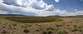
 Upper Red Rock Lake and Centennial Mountains.jpg 1.024×576; 304 kB
-
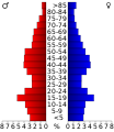 USA Beaverhead County, Montana age pyramid.svg 520×600; 8 kB
-
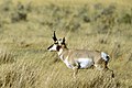 Wildlife59 (39046240852).jpg 2.250×1.500; 4,64 MB


.jpg)


.jpg)
.jpg)
.jpg)


.jpg)
.jpg)
.jpg)
.jpg)
.jpg)
(NRCS_Photo_Gallery).jpg)
(NRCS_Photo_Gallery).jpg)


.jpg)
.jpg)