Category:Bismarckturm (Zehdenick)
Jump to navigation
Jump to search
| Object location | | View all coordinates using: OpenStreetMap |
|---|
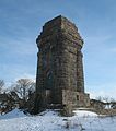
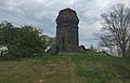
observation tower near Zehdenick in Brandenburg  | |||||
| Upload media | |||||
| Instance of | |||||
|---|---|---|---|---|---|
| Named after | |||||
| Made from material | |||||
| Location | Zehdenick, Oberhavel District, Brandenburg, Germany | ||||
| Architect | |||||
| Heritage designation | |||||
| Height |
| ||||
 | |||||
This is the category of the Brandenburger Baudenkmal (cultural heritage monument) with the ID 09165369 (Wikidata)
|
Media in category "Bismarckturm (Zehdenick)"
The following 5 files are in this category, out of 5 total.
-
 Hohetimp.jpg 960 × 1,280; 200 KB
-
 Klein Mutz Bismarck tower SW.jpg 2,200 × 2,960; 932 KB
-
 Klein Mutz Bismarck tower.jpg 2,304 × 2,600; 608 KB
-
 Klein-MutzBismarcktårn1.jpg 2,664 × 1,716; 317 KB
-
 Klein-MutzBismarcktårn2.jpg 3,264 × 2,448; 337 KB


Categories:
- Buildings in Zehdenick
- Cultural heritage monuments in Zehdenick
- Towers in Landkreis Oberhavel
- Bismarck towers in Brandenburg
- Bismarck towers built in 1900
- Built in Brandenburg in 1900
- Observation towers in Brandenburg
- Stone towers in Brandenburg
- Tetragonal towers in Brandenburg
- 14-meter-tall buildings in Germany
- Götterdämmerung (Wilhelm Kreis)