Category:Bohai Sea
Jump to navigation
Jump to search
English: Bohai Sea — the innermost gulf of the Yellow Sea, on the Pacific Ocean coast of North-Central China.
sea in China  A Pohaj-tenger űrfelvételen   | |||||
| Upload media | |||||
| Instance of |
| ||||
|---|---|---|---|---|---|
| Part of | |||||
| Location |
| ||||
| Has part(s) |
| ||||
| Area |
| ||||
| Inflows |
| ||||
 | |||||
Subcategories
This category has the following 7 subcategories, out of 7 total.
Media in category "Bohai Sea"
The following 33 files are in this category, out of 33 total.
-
 Bi jia shan at high tide.JPG 3,008 × 2,000; 2.54 MB
-
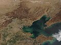
 Bohai Sea (MODIS 2019-09-05).jpg 3,556 × 2,896; 1.1 MB
-
 Bohai sea aquaculture planet labs satellite image.jpg 2,659 × 1,995; 1.59 MB
-
 Bohai Sea, China (MODIS 2019-04-16).jpg 4,425 × 3,274; 1.66 MB
-
 Bohaiaqua l7 2000123 lrg.jpg 3,300 × 2,200; 4.59 MB
-
 Bohaiaqua mss 1979147 lrg.jpg 1,650 × 1,100; 2.26 MB
-
 China.A2002249.0255.250m.jpg 4,400 × 3,400; 2.14 MB
-
 Frozen Waters in the Bohai Sea (MODIS 2021-02-02).jpg 2,073 × 1,711; 444 KB
-
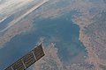
 ISS043-E-162753 - View of Earth.jpg 4,928 × 3,280; 1.34 MB
-
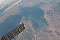
 ISS043-E-162754 - View of Earth.jpg 4,928 × 3,280; 1.44 MB
-
 ISS043-E-162755 - View of Earth.jpg 4,928 × 3,280; 1.28 MB
-
 ISS043-E-162756 - View of Earth.jpg 4,928 × 3,280; 1.38 MB
-
 ISS043-E-162757 - View of Earth.jpg 4,928 × 3,280; 1.48 MB
-
 ISS043-E-162758 - View of Earth.jpg 4,928 × 3,280; 1.32 MB
-
 ISS043-E-162759 - View of Earth.jpg 4,928 × 3,280; 1.36 MB
-
 ISS043-E-162760 - View of Earth.jpg 4,928 × 3,280; 1.47 MB
-
 ISS043-E-162761 - View of Earth.jpg 4,928 × 3,280; 1.29 MB
-
 Le Tour du monde-01-p152a.jpg 620 × 374; 89 KB
-
 Le Tour du monde-01-p152b.jpg 620 × 372; 87 KB
-
 Northern China - Envisat.jpg 1,920 × 1,269; 1.5 MB
-
 ROC1929-01-24國民政府公報74.pdf 879 × 1,239, 14 pages; 674 KB
-
 Seashore for Bohai at Laolongtou Site.jpg 4,608 × 3,456; 2.54 MB
-
 Sediment in Bohai Sea (MODIS 2019-06-12).jpg 1,803 × 1,555; 395 KB
-
 Seeing towards to Bohai Sea at Old Dragon Head.jpg 4,608 × 3,456; 4.02 MB
-
 Smog (Satellite picture) - 2.jpg 5,568 × 3,712; 3.63 MB
-
 Smog (Satellite picture).jpg 5,568 × 3,712; 3.85 MB
-
 Termination of the Great Wall.jpg 2,255 × 1,500; 421 KB
-
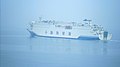
 青山岛号右舷救生艇.jpg 2,656 × 3,984; 2.34 MB
-
 青山岛号在船尾的甲板上看海.jpg 3,984 × 2,656; 2.93 MB
-
 青山岛号甲板上看渤海珍珠号.jpg 3,968 × 2,232; 2 MB
-
 青山岛号船尾吊臂与海鸥.jpg 1,024 × 682; 62 KB
-
 鲅鱼圈山海广场 (cropped).jpg 1,467 × 1,098; 688 KB
-
 鲅鱼圈山海广场.jpg 3,264 × 2,448; 3.04 MB

.jpg)
.jpg)


.jpg)


.jpg)

_-_2.jpg)
.jpg)


.jpg)
