Category:Maps of the Bohai Sea
Jump to navigation
Jump to search
Media in category "Maps of the Bohai Sea"
The following 31 files are in this category, out of 31 total.
-
 "Xantung, Sinarum Imperii provincia quarta." (21632336863).jpg 3,691 × 3,025; 2.09 MB
-
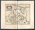 Xantvng - Atlas Maior, vol 11, map 16 - Joan Blaeu, 1667 - BL 114.h(star).11.(16).jpg 4,000 × 3,428; 1.94 MB
-

-
 Admiralty Chart No 1256 China, east coast Yellow Sea and Gulf of Pe-chili, Published 1840.jpg 7,466 × 5,815; 15.37 MB
-
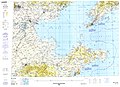
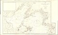 Admiralty Chart No 1256 Gulfs of Pohai and Liaotung, Published 1862, Large Corrections to 1950.jpg 18,365 × 11,170; 33.99 MB
-
 Admiralty Chart No 3378 Chinwangtao, Published 1946.jpg 11,120 × 16,258; 56.12 MB
-
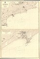
 Admiralty Chart No 3378 Gulf of Chihli Rocky Point to Temple Head, Published 1903.jpg 11,133 × 8,079; 29.76 MB
-
 Atlas Van der Hagen-KW1049B13 039-XANTVNG SINARVM IMPERII PROVICIA QUARTA.jpeg 5,500 × 4,523; 3.67 MB
-
 Bohai map-fr.svg 320 × 335; 85 KB
-
 Bohai map-mk.svg 320 × 335; 194 KB
-
 Bohai Sea map bs.svg 1,004 × 982; 643 KB
-
 Bohai Sea map hr.svg 1,004 × 982; 394 KB
-
 Bohai Sea map hu.png 1,229 × 1,204; 370 KB
-
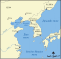
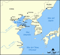
 Bohai Sea map.png 922 × 903; 231 KB
-
 Bohai Sea.gif 371 × 181; 10 KB
-
 Bohaisea.svg 571 × 488; 117 KB
-
 Bohaiseamap2 de.png 583 × 500; 150 KB
-
 Bohaiseamap2 hu.svg 569 × 487; 141 KB
-
 Bohaiseamap2.png 569 × 487; 136 KB
-
 Bohaitunnel.jpg 960 × 720; 50 KB
-
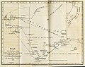 Gulph of Petchelee 1816.jpg 1,200 × 954; 160 KB
-
 Locatie Bohaizee.PNG 650 × 540; 14 KB
-
 Mapa del Mar de Bohai.png 1,000 × 913; 301 KB
-
 Mar de Bohai.png 1,000 × 913; 334 KB
-
 Nagranggun.jpg 290 × 270; 49 KB
-
 Nagrangun2.jpg 290 × 270; 42 KB
-
 Seaways Plan for the Bohai Sea.svg 3,414 × 1,935; 369 KB
-
 Txu-pclmaps-oclc-22834566 g-10a.jpg 9,421 × 6,846; 16.03 MB
-
 Xantung, sinarum imperii provincia quarta - (tiré du P. Martini) - btv1b5963044d.jpg 5,896 × 4,832; 4.73 MB
-
 Zhs Bohaiseamap2.png 583 × 500; 24 KB
-
 Zht Bohaiseamap2.png 583 × 500; 25 KB
.jpg)
.11.(16).jpg)


_-_btv1b5963044d.jpg)

