Category:Brèche de Roland
Jump to navigation
Jump to search
foot pass in the Pyrénées on the French–Spanish border   | |||||
| Upload media | |||||
| Instance of | |||||
|---|---|---|---|---|---|
| Located in protected area | |||||
| Location |
| ||||
| Mountain range | |||||
| Elevation above sea level |
| ||||
 | |||||
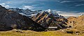
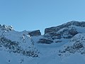
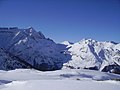
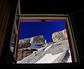
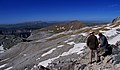
The Breche de roland (Aragonese: Breca Roldán, Spanish: Brecha de rolando) is an impressive natural gap, 40 m across and 100 m high, at an altitude of 2804 m in the steep cliffs of the Cirque de Gavarnie.
Media in category "Brèche de Roland"
The following 82 files are in this category, out of 82 total.
-
 2019 - Parc national des Pyrenees - refuge des Espuguettes.jpg 10,075 × 4,405; 17.71 MB
-
 BattleofRoncevauxWvBibra.jpg 4,491 × 7,138; 3.84 MB
-
 BRECHA DE ROLANDO - panoramio.jpg 4,288 × 2,848; 4.98 MB
-
 Brecha de Rolando - WLE Spain 2015 (1).jpg 4,912 × 1,080; 2.6 MB
-
 Brecha de Rolando - WLE Spain 2015.jpg 2,736 × 3,648; 3.21 MB
-
 BRECHA DE ROLANDO DESDE LLEGADA AL COLLADO DE SERRADETS - panoramio.jpg 4,105 × 2,538; 3.45 MB
-
 BRECHA DE ROLANDO DESDE SERRADETS - panoramio.jpg 4,288 × 2,848; 5.59 MB
-
 Brecha de Rolando.jpg 5,999 × 3,329; 17.75 MB
-
 Brecha rolando.jpg 534 × 801; 43 KB
-
 Brecha Roldan.jpg 3,072 × 2,304; 3.1 MB
-
 Breche de Roland en El Dedo.jpg 2,819 × 1,875; 2.22 MB
-
 Breche de Roland Espuguettes.jpg 2,560 × 1,920; 2.27 MB
-
 Brèche de Roland 20060821a.jpg 2,272 × 1,704; 3.34 MB
-
 Brèche de Roland 20060821b.jpg 2,272 × 1,704; 2.98 MB
-
 Brèche de Roland 20060821c.jpg 1,704 × 2,272; 2.91 MB
-
 Brèche de Roland 20060821d.jpg 1,704 × 2,272; 2.85 MB
-
 Brèche de Roland 20060821f.jpg 2,272 × 1,704; 3.2 MB
-
 Brèche de Roland depuis le refuge des Sarradets.jpg 3,822 × 3,168; 1.16 MB
-
 Brèche de Roland depuis le vallon des Sarradets.jpg 4,752 × 3,168; 1.8 MB
-
 Brèche de Roland en mai.JPG 3,072 × 2,304; 2.69 MB
-
 Brèche de Roland.jpg 1,024 × 266; 180 KB
-
 Brèche de Roland.png 522 × 454; 322 KB
-

-
 Casco de Marboré.jpg 960 × 720; 123 KB
-
 Casque du Marboré et brèche de Roland.jpg 4,752 × 2,538; 1.29 MB
-
 Circo cotatuero.jpg 801 × 534; 187 KB
-
 Cirque-de-Gavarnie.jpg 2,272 × 1,704; 918 KB
-
 De Brèche de Roland en de 'Dedo'.jpg 2,617 × 1,000; 2.24 MB
-
 Die Gartenlaube (1885) b 012.jpg 3,104 × 5,000; 4.1 MB
-
 El circ de Gavarnie des de la bretxa de Roland.jpg 1,024 × 742; 84 KB
-
 El Taillón i la Falsa Bretxa en una carena muntanyosa amb neu.jpeg 1,024 × 742; 94 KB
-
 FRAC31555 67Fi122 - -Pyrénées. Gavarnie. Brèche de Roland-.tif 3,303 × 1,658; 15.69 MB
-
 FRAC31555 67Fi36 - Pyrénées. Gavarnie. Brèche de Roland.tif 2,871 × 2,191; 18.02 MB
-
 FRAC31555 67Fi97 - -Pyrénées. Brèche de Roland.tiff 1,617 × 3,219; 14.92 MB
-

-
 Glacier de la Brèche - 1.jpg 4,488 × 4,352; 3.45 MB
-
 Grup d'alpinistes dinant en una bauma de la bretxa de Rotllan.jpeg 1,024 × 414; 87 KB
-
 J20 968 Brecha de Rolando.jpg 5,604 × 3,736; 3.28 MB
-
 J20 969 Circo de Cotatuero, Brecha de Rolando.jpg 5,622 × 3,748; 4.69 MB
-
 J20 970 Circo de Cotatuero, Brecha de Rolando.jpg 3,748 × 5,622; 3.49 MB
-
 La Brecha de Rolando.jpeg 560 × 768; 53 KB
-
 La breche de roland 2.jpg 1,200 × 1,600; 405 KB
-
 La breche de roland 3.jpg 2,290 × 1,209; 413 KB
-
 La bretxa de Roland amb neu en primer terme.jpeg 1,024 × 750; 87 KB
-
 La bretxa de Roland amb una glacera i neu en primer terme.jpeg 1,024 × 748; 115 KB
-
 La bretxa de Roland i muntanyes amb neu.jpeg 1,024 × 741; 129 KB
-
 La Bretxa de Roland, a Monte Perdido.jpeg 571 × 768; 60 KB
-
 La Bretxa de Rotllan.jpeg 1,024 × 429; 68 KB
-
 La bretxa Roland des d'un vessant nevat.jpeg 1,024 × 744; 109 KB
-
 La Brèche de Roland (50251355687).jpg 4,928 × 3,264; 10 MB
-
 La Brèche de Roland - Vue du Chaos - Fonds Ancely - B315556101 A MONTHELIER 1 2 021.jpg 1,832 × 2,840; 1,012 KB
-
 La brèche de Roland depuis le pic des tentes - panoramio.jpg 1,584 × 2,816; 1.98 MB
-
 Lado Español de la Brecha de Rolando.jpg 1,722 × 994; 2.22 MB
-
 Massif d'Ardiden vu depuis la brèche de Roland.jpg 4,644 × 2,376; 1.24 MB
-
 Ordesa - 7.JPG 4,000 × 3,000; 4.39 MB
-
 Ordesa, Faja de Pelay 1993 11.jpg 1,068 × 698; 190 KB
-

-
 Paisatge nevat amb dos alpinistes i la bretxa de Rotllan.jpeg 1,024 × 414; 74 KB
-
 Parets de la bretxa Roland amb neu (AFCEC SOLER D 0289bis).jpeg 566 × 768; 57 KB
-
 Parets de la bretxa Roland amb neu.jpeg 563 × 768; 59 KB
-
 Quatre alpinistes a la glacera de la bretxa de Rotllan.jpeg 1,024 × 415; 48 KB
-
 RefugeDesSarradets BrècheDeRoland.jpg 2,148 × 1,504; 2.37 MB
-
 Refugio Serradets.jpg 2,048 × 1,536; 550 KB
-
 Roland Breach (7132674197).jpg 3,888 × 2,592; 2.03 MB
-
 RolandACloss.jpg 6,000 × 9,626; 25.82 MB
-
 Rolandbreche.jpg 2,000 × 1,307; 509 KB
-
 Spaanse aanloop Breche de Roland.jpg 3,008 × 2,000; 2.89 MB
-
 Spain 2013-07-31 (9689041886).jpg 4,752 × 2,724; 1.5 MB
-
 Spain 2013-07-31 (9689048050).jpg 3,168 × 4,224; 1.63 MB
-
 Spain 2013-07-31 (9689049422).jpg 4,470 × 2,610; 1.48 MB
-
 Spain 2013-07-31 (9689051004).jpg 4,242 × 3,168; 1.64 MB
-
 Spain 2013-07-31 (9689052758).jpg 4,752 × 3,168; 1.84 MB
-
 Spain 2013-07-31 (9689056206).jpg 4,752 × 2,946; 2.07 MB
-
 Spain 2013-07-31 (9692273168).jpg 4,752 × 2,508; 1.38 MB
-
 Storïau Mawr y Byd (page 154 crop).jpg 1,583 × 2,322; 581 KB
-
The Pyrenees by Drone - Breche de Roland - Avalanche-Cirque de Gavarnie - Ordesa in 4K.webm 4 min 16 s, 3,840 × 2,160; 527.35 MB
-
 Vallon des Sarradets.jpg 4,752 × 3,168; 2.42 MB
-
 Vista de la bretxa de Rotllan amb neu.jpeg 1,024 × 411; 57 KB
-
 Vista de la bretxa de Rotllan i el Casc amb neu.jpeg 1,024 × 416; 66 KB
-
 Vista de la bretxa de Rotllan.jpeg 1,024 × 413; 99 KB
-
 Vista parcial de la bretxa de Rotllan amb neu.jpeg 1,024 × 412; 59 KB
-
 Vue prise de la brèche de Roland (Pyrénées).JPG 2,816 × 2,112; 2.49 MB


_(3%C2%B0_liv.,_pl._20)_-_Fonds_Ancely_-_B315556101_A_FROSSARD_1_048.jpg)


_b_012.jpg)


_-_Fonds_Ancely_-_B315556101_A_BROWN_024-026.jpg)


.jpg)


.jpeg)


.jpg)


.jpg)
.jpg)
.jpg)
.jpg)
.jpg)
.jpg)
.jpg)
.jpg)

.JPG)
.jpg)