Category:Changanassery
town in Kottayam district, Kerala  | |||||
| Carica un file multimediale | |||||
| Istanza di | |||||
|---|---|---|---|---|---|
| Luogo | |||||
| Altezza sul mare |
| ||||
 | |||||
Changanassery (Malayalam: ചങ്ങനാശ്ശേരി) is a town and municipality in Kottayam district in the state of Kerala, India. It is located between Kottayam and Thiruvalla townships - 18 km from Kottayam town. It is known as the Gateway to High Range (hill resorts) and Kuttanadu (Backwaters). In the past, the town was known as Anchu Vilakkinte Pattanam, meaning "Town of five fire lamps", which symbolises unity and points to old business time. Changancherry was an old business place during the pre-British Raj. During the renovation of Travancore, Changanacherry was the boundary and was called Thekkum koor. 9°28′0″N 76°33′0″E / 9.46667°N 76.55°E
Sottocategorie
Questa categoria contiene le 6 sottocategorie indicate di seguito, su un totale di 6.
File nella categoria "Changanassery"
Questa categoria contiene 4 file, indicati di seguito, su un totale di 4.
-
 Kavil Bhagavathy Temple Deity.jpg 2 340 × 4 160; 2,9 MB
-
 Map of Thekkumkur in 1790.jpg 2 320 × 1 576; 711 KB
-
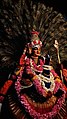 Mayilattam or Peacock Dance.jpg 2 340 × 4 160; 2,8 MB
-
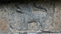 Symbol of Thekkumkur Dynasty.png 829 × 470; 741 KB


