Category:Churches in the London Borough of Hounslow
Jump to navigation
Jump to search

Wikimedia category | |||||
| Upload media | |||||
| Instance of | |||||
|---|---|---|---|---|---|
| Category combines topics | |||||
| London | |||||
capital and largest city of England and the United Kingdom     .svg)   | |||||
| Pronunciation audio | |||||
| Instance of |
| ||||
| Location |
| ||||
| Located in or next to body of water | |||||
| Official language | |||||
| Head of government |
| ||||
| Inception |
| ||||
| Significant event |
| ||||
| Highest point |
| ||||
| Population |
| ||||
| Area |
| ||||
| Elevation above sea level |
| ||||
| IATA airport code |
| ||||
| Different from | |||||
| official website | |||||
 | |||||
Subcategories
This category has the following 13 subcategories, out of 13 total.
Media in category "Churches in the London Borough of Hounslow"
The following 41 files are in this category, out of 41 total.
-
 All Saints, Broad Walk, Heston, TW5 - geograph.org.uk - 1750687.jpg 1,000 × 616; 137 KB
-
 All Saints, Broad Walk, Heston, TW5 - geograph.org.uk - 1750689.jpg 1,000 × 495; 141 KB
-
 Bethany Free Church, Bedfont - geograph.org.uk - 112529.jpg 640 × 480; 166 KB
-
 Brentford Free Church - geograph.org.uk - 2612922.jpg 640 × 430; 65 KB
-
 Brentford Free Church - geograph.org.uk - 2612926.jpg 640 × 430; 65 KB
-
 Brentford Free Church - geograph.org.uk - 4817932.jpg 1,024 × 759; 181 KB
-
 Brentford Free Church - geograph.org.uk - 5706048.jpg 851 × 1,280; 393 KB
-
 Brentford Free Church - geograph.org.uk - 5762409.jpg 1,067 × 1,600; 426 KB
-
 Brentford Free Church, - geograph.org.uk - 2652678.jpg 640 × 471; 82 KB
-
 Chiswick Baptist Church - geograph.org.uk - 4576646.jpg 1,543 × 2,163; 756 KB
-
 Chiswick Baptist Church - geograph.org.uk - 6615467.jpg 685 × 1,024; 139 KB
-
 Chiswick Seventh Day Adventist Church - geograph.org.uk - 2768613.jpg 1,280 × 949; 249 KB
-

-
 Congregational Church - geograph.org.uk - 3528377.jpg 640 × 430; 70 KB
-
 East Bedfont, Bethany Church - geograph.org.uk - 2412100.jpg 640 × 461; 64 KB
-
 Feltham, Christ Church - geograph.org.uk - 1160085.jpg 640 × 480; 65 KB
-
 Gunnersbury Baptist Church - geograph.org.uk - 2644837.jpg 480 × 640; 118 KB
-
 Gunnersbury Baptist Church - geograph.org.uk - 2644847.jpg 480 × 640; 145 KB
-

-
 Gunnersbury Baptist Church.jpg 4,608 × 3,456; 3.77 MB
-

-
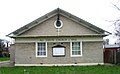
 Hounslow Spiritualist Church - geograph.org.uk - 108842.jpg 640 × 480; 206 KB
-
 Knife bin outside Holy Trinity Church Hounslow - geograph.org.uk - 3026957.jpg 3,264 × 2,448; 1.99 MB
-
 Lukes Mission Church - geograph.org.uk - 959110.jpg 640 × 480; 98 KB
-
 North Road Baptist Church - geograph.org.uk - 2653377.jpg 640 × 456; 49 KB
-
 Salvation Army Chapel - geograph.org.uk - 306454.jpg 427 × 640; 196 KB
-
 St Catherine's House - geograph.org.uk - 2503646.jpg 620 × 1,000; 107 KB
-
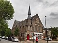
 St Dunstan's Church - geograph.org.uk - 2645020.jpg 640 × 480; 178 KB
-
 St Dunstan's Church, Gunnersbury - geograph.org.uk - 2445423.jpg 640 × 480; 119 KB
-
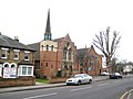
 St George's Church, Brentford - geograph.org.uk - 2652224.jpg 640 × 480; 66 KB
-
 St Luke, Hounslow East - East end - geograph.org.uk - 3472404.jpg 1,000 × 705; 187 KB
-
 St Luke, Hounslow East - geograph.org.uk - 3472401.jpg 1,000 × 564; 236 KB
-
 St Luke, Hounslow East - geograph.org.uk - 3472403.jpg 1,000 × 657; 300 KB
-
 St Luke, Hounslow East - Memorial WWII - geograph.org.uk - 3472408.jpg 933 × 1,000; 186 KB
-
 St Luke, Hounslow East - Sanctuary - geograph.org.uk - 3472406.jpg 1,000 × 688; 162 KB
-
 St Lukes Mission Church, Hounslow - geograph.org.uk - 3492519.jpg 800 × 600; 144 KB
-
 St Richard of Chichester, Forge Lane, Hanworth - geograph.org.uk - 1829587.jpg 1,000 × 717; 160 KB
-
 St Richard of Chichester, Forge Lane, Hanworth - geograph.org.uk - 1829593.jpg 910 × 1,000; 180 KB
-
 St Richard of Chichester, Forge Lane, Hanworth - geograph.org.uk - 1829603.jpg 1,000 × 688; 149 KB
-

-
 United Reformed Church, Heston - geograph.org.uk - 2240073.jpg 800 × 600; 309 KB


