Category:Clinton County, New York
Vai alla navigazione
Vai alla ricerca
Counties of New York (state): Albany · Allegany · Bronx · Broome · Cattaraugus · Cayuga · Chautauqua · Chemung · Chenango · Clinton · Columbia · Cortland · Delaware · Dutchess · Erie · Essex · Franklin · Fulton · Genesee · Greene · Hamilton · Herkimer · Jefferson · Kings · Lewis · Livingston · Madison · Monroe · Montgomery · Nassau · New York · Niagara · Oneida · Onondaga · Ontario · Orange · Orleans · Oswego · Otsego · Putnam · Queens · Rensselaer · Richmond · Rockland · Saratoga · Schenectady · Schoharie · Schuyler · Seneca · St. Lawrence · Steuben · Suffolk · Sullivan · Tioga · Tompkins · Ulster · Warren · Washington · Wayne · Westchester · Wyoming · Yates
contea statunitense dello stato di New York   | |||||
| Carica un file multimediale | |||||
| Istanza di | |||||
|---|---|---|---|---|---|
| Prende il nome da | |||||
| Luogo | New York, Stati Uniti d'America | ||||
| Situato sul mare / lago / fiume | |||||
| Capitale | |||||
| Data di fondazione o creazione |
| ||||
| Popolazione |
| ||||
| Superficie |
| ||||
| Distinto da | |||||
| sito web ufficiale | |||||
 | |||||
Sottocategorie
Questa categoria contiene le 16 sottocategorie indicate di seguito, su un totale di 16.
A
B
C
H
L
N
P
S
T
V
File nella categoria "Clinton County, New York"
Questa categoria contiene 30 file, indicati di seguito, su un totale di 30.
-
 20th Century Hatchet.jpg 4 032 × 3 024; 1,49 MB
-
 Andrew Williams (congressman).jpg 429 × 492; 33 KB
-
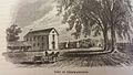
 Annual report (1903) (18429630415).jpg 4 192 × 2 545; 1,56 MB
-
 Beekmantown.jpg 5 312 × 2 988; 6,02 MB
-
 BlackBrookNY TownOffices.jpg 1 024 × 680; 254 KB
-
 Boathouse in Point au Roche state park.jpg 1 800 × 1 013; 1,31 MB
-
 Canadian border monitoring equipment at end of Roxham Road, Champlain, NY.jpg 3 024 × 6 048; 12,66 MB
-
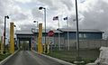 Churubusco Border Inspection Station.jpg 1 966 × 1 176; 403 KB
-
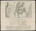 Commonwealth z603vn23b accessFull.jpg 13 350 × 11 738; 30,52 MB
-
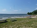
 Connor's Bay beach.jpg 1 800 × 3 200; 4,71 MB
-
 Doggologo.jpg 3 024 × 4 032; 1,72 MB
-
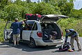 Emigrants unloading taxi at end of Roxham Road, Champlain, NY.jpg 5 564 × 3 708; 14,02 MB
-
 Examples of whittling.jpg 4 032 × 3 024; 428 KB
-
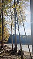
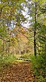 Fall colours on Point au Roche hiking trail.jpg 1 800 × 3 200; 5,89 MB
-
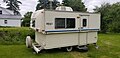 Hard Shell Pop up.jpg 4 032 × 1 960; 1,35 MB
-
 Lookout point at Point au Roche.jpg 1 600 × 2 845; 3,92 MB
-
 Map of New York highlighting Clinton County.svg 1 650 × 1 257; 66 KB
-
 New York State Route 189.jpg 2 560 × 1 920; 1,3 MB
-
 Overton Corners Boundary.jpg 1 360 × 2 048; 1,05 MB
-
 Point au Roche NY.jpg 1 800 × 3 200; 3,33 MB
-
 Point Au Roche State Park.jpg 2 500 × 1 875; 1,17 MB
-
 Redford Cemetery in the Rain, New York (30273957616).jpg 4 860 × 3 176; 6,03 MB
-
 US-Canadian border markers at Roxham Road, Champlain, NY-Lacolle, QC.jpg 5 280 × 3 252; 15,49 MB
-
 USA Clinton County, New York age pyramid.svg 520 × 600; 7 KB
-
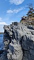
 View north from Poke-O-Moonshine fire tower.jpg 2 490 × 1 482; 2,93 MB
-
 Visitor Center Point au Roche.jpg 3 200 × 1 800; 3,69 MB
-
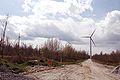 Wind farm in Clinton County 2454534827.jpg 2 880 × 1 920; 1,56 MB
-
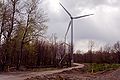
 Wind farm in Clinton County 2454535631.jpg 2 298 × 3 456; 2,81 MB
-
 Wind farm in Clinton County 2454536327.jpg 3 376 × 2 244; 2,91 MB
-


.jpg)
_(18429630415).jpg)


.jpg)


