Category:Colmonell
Jump to navigation
Jump to search
English: Colmonell is a small village in the Stinchar Valley, South Ayrshire. The nearest town is Girvan, ten miles away.
village in South Ayrshire, Scotland, UK  | |||||
| Upload media | |||||
| Instance of | |||||
|---|---|---|---|---|---|
| Location |
| ||||
 | |||||
Subcategories
This category has the following 4 subcategories, out of 4 total.
Media in category "Colmonell"
The following 137 files are in this category, out of 137 total.
-
 05329 Church of Scotland, Colmonell 026.jpg 480 × 640; 168 KB
-
 A monument in the trees - geograph.org.uk - 775296.jpg 640 × 480; 98 KB
-

-
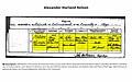 Alexander Marland Nelson b 1858.jpg 2,570 × 1,602; 480 KB
-
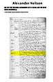 Alexander Neilson b 1782.jpg 1,050 × 1,614; 200 KB
-
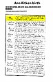 Ann Aitken b 1823.jpg 1,089 × 1,692; 281 KB
-
 Arriving at Colmonell (geograph 5054489).jpg 1,873 × 1,280; 548 KB
-
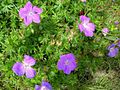 Bloody Cranesbill - geograph.org.uk - 471116.jpg 640 × 480; 146 KB
-
 Chirmorie Cairn - geograph.org.uk - 597234.jpg 640 × 480; 80 KB
-
 Chirmorie farm - geograph.org.uk - 597289.jpg 640 × 480; 81 KB
-
 Chirmorrie - geograph.org.uk - 896567.jpg 640 × 428; 108 KB
-

-
 Colmonell (geograph 3400803).jpg 5,184 × 3,456; 6.51 MB
-
 Colmonell Parish Church - geograph.org.uk - 1500407.jpg 427 × 640; 129 KB
-
 Colmonell Village - geograph.org.uk - 1579291.jpg 640 × 455; 84 KB
-
 Colmonnel, Manse Street, South Ayrshire. View east.jpg 4,896 × 2,752; 3.48 MB
-
 Common Spotted Orchid - geograph.org.uk - 471119.jpg 450 × 600; 79 KB
-
 Corwar Cottage - geograph.org.uk - 499771.jpg 640 × 480; 126 KB
-
 Covenanter's Gravestone Colmonell - geograph.org.uk - 625846.jpg 459 × 640; 121 KB
-
 Derelict bothy at Chirmorrie - geograph.org.uk - 896580.jpg 640 × 428; 59 KB
-

-
 Dunnack Burn - geograph.org.uk - 723693.jpg 640 × 479; 91 KB
-
 Fall of poppies on Colmonell Community Centre (geograph 5970925).jpg 3,264 × 2,448; 2.77 MB
-

-
 Forest track near Corwar - geograph.org.uk - 1604064.jpg 640 × 480; 71 KB
-
 Forestry road sign - geograph.org.uk - 499769.jpg 640 × 480; 196 KB
-
 Joanna Henry b 1879.jpg 2,322 × 1,764; 517 KB
-
 John Nelson et Ann Aitken m 1848.jpg 1,441 × 1,896; 263 KB
-
 Knockdolian Vault coat of arms detail, St Colmon's Church, Colmonell, South Ayrshire.jpg 2,480 × 2,169; 1.21 MB
-
 Knockdolian Vault entrance, St Colmon's Church, Colmonell, South Ayrshire.jpg 3,063 × 2,726; 2.44 MB
-
 Knockdolian Vault. MacCubbins and McConnel's memorials. Colmonell..jpg 3,959 × 2,738; 2.88 MB
-
 Loch Nahinie - geograph.org.uk - 476093.jpg 640 × 480; 116 KB
-
 Main Street, Colmonell (geograph 2694463).jpg 2,000 × 1,302; 682 KB
-
 McConnel memorials, The Knockdolian Vault, St Colmon's Church, Colmonell, South Ayrshire.jpg 2,961 × 1,879; 1.76 MB
-
 Northern Brown Argus - geograph.org.uk - 471124.jpg 640 × 459; 106 KB
-
-
 Resurrection Stone, St Colmon's Church, Colmonell, South Ayrshire.jpg 2,939 × 2,434; 1.42 MB
-

-
 Sheepfold east of Chirmorie Cairn - geograph.org.uk - 896591.jpg 640 × 428; 48 KB
-
 Shuttle Bus, Colmonell (geograph 5054524).jpg 1,920 × 1,280; 1.63 MB
-
 Spot The Insect - geograph.org.uk - 471125.jpg 432 × 600; 115 KB
-
 St Colmon's Church manse, Colmonell, South Ayrshire.jpg 4,896 × 2,752; 3.52 MB
-
 St Colmon's Church, Colmonell, South Ayrshire. West end.jpg 4,896 × 2,752; 2.67 MB
-
 St Colmon's churchyard, Colmonnel, South Ayrshire. View south-west.jpg 4,896 × 2,752; 4.97 MB
-
 Summit ridge, Ailsa Craig.jpg 640 × 480; 88 KB
-
 Sunsetting on Paddy's milestone - geograph.org.uk - 389532.jpg 640 × 430; 32 KB
-
 The Knockdolian Vault entrance detail, St Colmon's Church, Colmonell, South Ayrshire.jpg 3,993 × 2,534; 2.8 MB
-

-
 The Knockdolian Vault, St Colmon's Church, Colmonell, South Ayrshire.jpg 4,257 × 2,487; 2.75 MB
-
 The Lairds Loft Steps, St Colmon's Church, Colmonell, South Ayrshire.jpg 4,896 × 2,752; 2.84 MB
-
 The River Stinchar - geograph.org.uk - 770228.jpg 640 × 480; 72 KB
-
 View of gravestones, Colmonell, South Ayrshire. East area.jpg 4,896 × 2,752; 4.02 MB
-
 View towards Colmonell (geograph 4532583).jpg 5,184 × 3,456; 6.87 MB
-
 War Commemorative figure. St Colmon's, Colmonell, South Ayrshire.jpg 3,359 × 2,717; 2.54 MB
-
 A Pool In Almont Forest - geograph.org.uk - 1492537.jpg 640 × 426; 123 KB
-
 A Poor Cone Crop - geograph.org.uk - 1492473.jpg 640 × 436; 105 KB
-
 A Winter View - geograph.org.uk - 1094858.jpg 640 × 426; 105 KB
-
 Above Glen Tig - geograph.org.uk - 1094872.jpg 640 × 426; 110 KB
-
 All The Way Down - geograph.org.uk - 1199692.jpg 399 × 600; 71 KB
-
 Almont Forest Track - geograph.org.uk - 1492506.jpg 640 × 426; 111 KB
-
 Almont, near Pinwherry - geograph.org.uk - 263123.jpg 640 × 480; 60 KB
-
 Arecleoch Forest - geograph.org.uk - 723686.jpg 640 × 479; 72 KB
-
 Arecleoch Forest - geograph.org.uk - 723689.jpg 640 × 479; 66 KB
-
 Arecleoch Forest - geograph.org.uk - 723690.jpg 640 × 479; 73 KB
-
 At The End Of The Other Track - geograph.org.uk - 1492499.jpg 640 × 426; 107 KB
-
 Autumn Colours In Almont Forest - geograph.org.uk - 1492489.jpg 640 × 426; 119 KB
-
 Autumn hedgerow near Liggetcheek - geograph.org.uk - 263042.jpg 640 × 480; 112 KB
-

-
 Balkissock Hill - geograph.org.uk - 693338.jpg 640 × 479; 67 KB
-
 Balkissock Hill - geograph.org.uk - 693392.jpg 640 × 479; 112 KB
-
 Belhamie - geograph.org.uk - 333577.jpg 640 × 480; 66 KB
-
 Beside The Forest Track - geograph.org.uk - 1492549.jpg 640 × 426; 125 KB
-
 Birds on rocks near Lendalfoot - geograph.org.uk - 775302.jpg 640 × 480; 60 KB
-
 Bougang Farm - geograph.org.uk - 263040.jpg 640 × 480; 63 KB
-

-
 By The Garna Burn - geograph.org.uk - 1493599.jpg 640 × 426; 98 KB
-
 Carleton Bay - geograph.org.uk - 1473604.jpg 640 × 457; 255 KB
-
 Caterpillar Tracks - geograph.org.uk - 1492555.jpg 640 × 426; 111 KB
-
 Cattle Grid - geograph.org.uk - 1493610.jpg 640 × 419; 75 KB
-
 Cattle on the hill above Lendalfoot - geograph.org.uk - 263174.jpg 640 × 480; 91 KB
-
 Chalets at Lendalfoot - geograph.org.uk - 333583.jpg 640 × 480; 62 KB
-
 Colmonell Old Cemetery and Manse - geograph.org.uk - 625822.jpg 640 × 480; 102 KB
-
 Colmonell Public Hall - geograph.org.uk - 263056.jpg 640 × 480; 60 KB
-
 Colmonell Village - geograph.org.uk - 770231.jpg 640 × 442; 67 KB
-
 Corseclays Farm, near Ballantrae - geograph.org.uk - 331957.jpg 640 × 480; 60 KB
-
 Cows on the road - geograph.org.uk - 263186.jpg 640 × 480; 68 KB
-
 Craig Cottage - geograph.org.uk - 333340.jpg 640 × 480; 72 KB
-
 Cundry Mains, Lendalfoot - geograph.org.uk - 263190.jpg 640 × 480; 70 KB
-

-

-
 Dunnack Burn - geograph.org.uk - 693406.jpg 640 × 479; 117 KB
-
 Dunnack Burn - geograph.org.uk - 723691.jpg 640 × 479; 89 KB
-
 Eldridge Forest - geograph.org.uk - 693378.jpg 640 × 479; 72 KB
-
 Entrance to Laggan House Leisure Park - geograph.org.uk - 263046.jpg 640 × 480; 95 KB
-
 Farm track south of Lendalfoot - geograph.org.uk - 1436930.jpg 640 × 480; 75 KB
-
 Field gate near Craig Farm, Colmonell - geograph.org.uk - 263114.jpg 640 × 480; 79 KB
-
 Field near Corseclays - geograph.org.uk - 263033.jpg 640 × 480; 90 KB
-

-
 Hillside at Liggetcheek - geograph.org.uk - 331961.jpg 640 × 480; 108 KB
-
 House near Glen Tig - geograph.org.uk - 331962.jpg 640 × 480; 68 KB
-

-
 Kirkholm Cottage - geograph.org.uk - 331960.jpg 480 × 640; 107 KB
-

-
 Leffin Donald Hill - geograph.org.uk - 693319.jpg 640 × 479; 59 KB
-
 Livevstock pens in the Stinchar valley - geograph.org.uk - 263048.jpg 640 × 480; 104 KB
-
 Main Street, Colmonell - geograph.org.uk - 331971.jpg 640 × 480; 56 KB
-
 Mains of Tig - geograph.org.uk - 331964.jpg 640 × 480; 75 KB
-
 Moorland at Mossgavel - geograph.org.uk - 331958.jpg 640 × 480; 97 KB
-
 Mossgavel Service Reservoir - geograph.org.uk - 263034.jpg 640 × 480; 76 KB
-
 New barn just outside Colmonell - geograph.org.uk - 333781.jpg 640 × 480; 62 KB
-
 New Planting - geograph.org.uk - 476205.jpg 640 × 446; 90 KB
-
 Old caravan at Lendal Lodge - geograph.org.uk - 263193.jpg 640 × 480; 82 KB
-
 Pinbain Burn at the A77 - geograph.org.uk - 471126.jpg 640 × 468; 87 KB
-
 Pinbain Burn SSSI - geograph.org.uk - 471113.jpg 450 × 600; 75 KB
-
 Pinbraid Fishery (lower end) - geograph.org.uk - 263192.jpg 640 × 480; 67 KB
-
 Pinbraid Fishery (upper end) - geograph.org.uk - 263185.jpg 640 × 480; 65 KB
-
 Pinbraid Loch - geograph.org.uk - 324925.jpg 640 × 480; 256 KB
-
 Polcardoch in the Stinchar valley - geograph.org.uk - 263038.jpg 640 × 480; 70 KB
-
 Poundland - geograph.org.uk - 263120.jpg 640 × 480; 63 KB
-

-
 Redundant church in Colmonell - geograph.org.uk - 263112.jpg 480 × 640; 75 KB
-
 Reflections On The Burn - geograph.org.uk - 476106.jpg 447 × 600; 83 KB
-
 Roses round the door - geograph.org.uk - 263045.jpg 640 × 480; 61 KB
-
 Sallochan in the Stinchar valley - geograph.org.uk - 263047.jpg 640 × 480; 87 KB
-
 Sheep may safely graze - geograph.org.uk - 263106.jpg 640 × 480; 88 KB
-
 Small mobile home site at Lendalfoot - geograph.org.uk - 333782.jpg 640 × 480; 80 KB
-
 South Ballaird Farmhouse - geograph.org.uk - 350769.jpg 640 × 480; 49 KB
-
 Stinchar Valley viewed from Almont - geograph.org.uk - 333352.jpg 640 × 480; 77 KB
-
 Stream below Pinbraid Loch - geograph.org.uk - 333783.jpg 640 × 480; 78 KB
-
 The Battery Pool. River Stinchar - geograph.org.uk - 423379.jpg 640 × 451; 113 KB
-
 The Gate at Dangart - geograph.org.uk - 467054.jpg 640 × 458; 104 KB
-
 Towards Lendalfoot - geograph.org.uk - 471110.jpg 640 × 480; 61 KB
-
 Towards Lendalfoot - geograph.org.uk - 471128.jpg 640 × 480; 59 KB
-
 Trees along the Water of Lendal - geograph.org.uk - 263187.jpg 640 × 480; 60 KB
-
 Valley of the Water of Lendal - geograph.org.uk - 263194.jpg 480 × 640; 71 KB
-
 View of Balrazzie Fells - geograph.org.uk - 693421.jpg 640 × 479; 67 KB
-
 Whilk Isle - geograph.org.uk - 330769.jpg 640 × 480; 241 KB


.jpg)


.jpg)


.jpg)


.jpg)


.jpg)


.jpg)


_near_to_Ballantrae_and_Colmonell,_South_Ayrshire._-_geograph.org.uk_-_642757.jpg)


_-_geograph.org.uk_-_263192.jpg)
_-_geograph.org.uk_-_263185.jpg)


