Category:South Ayrshire
Jump to navigation
Jump to search
Council areas (municipalities) of Scotland: Aberdeen · Aberdeenshire · Angus · Argyll and Bute · Clackmannanshire · Dumfries and Galloway · Dundee · East Ayrshire · East Dunbartonshire · East Lothian · East Renfrewshire · Edinburgh · Falkirk · Fife · Glasgow · Highland · Inverclyde · Midlothian · Moray · North Ayrshire · North Lanarkshire · Outer Hebrides · Orkney Islands · Perth and Kinross · Renfrewshire · Scottish Borders · Shetland Islands · South Ayrshire · South Lanarkshire · Stirling · West Dunbartonshire · West Lothian
council area in Scotland   | |||||
| Upload media | |||||
| Instance of | |||||
|---|---|---|---|---|---|
| Part of |
| ||||
| Location | Scotland | ||||
| Capital | |||||
| Population |
| ||||
| Area |
| ||||
| official website | |||||
 | |||||


Subcategories
This category has the following 39 subcategories, out of 39 total.
A
- A79 road (Scotland) (13 F)
B
- Bargany Pit and Coal Washery (2 F)
C
- Campcastle Farm (3 F)
- Coilsfield Deer Hay (8 F)
- Craigie Inn (1 F)
- Craigie Quarry (1 F)
- Craigie War Memorial (1 F)
D
- Dunure Labyrinth (10 F)
E
F
G
H
- Hadyard Hill Wind Farm (15 F)
- Hedges in South Ayrshire (13 F)
- House of Craigie (2 F)
I
M
N
P
- Pavilions in South Ayrshire (1 F)
S
T
- The Adair Monument (8 F)
V
Media in category "South Ayrshire"
The following 200 files are in this category, out of 955 total.
(previous page) (next page)-
 A boring view of a beach - geograph.org.uk - 2652196.jpg 2,000 × 1,500; 536 KB
-
 A Fine Headstone In Tarbolton Churchyard - geograph.org.uk - 1305041.jpg 426 × 640; 153 KB
-
 A lay-by beside the A77 looking northeast - geograph.org.uk - 3517313.jpg 3,930 × 2,904; 1.66 MB
-
 A Leisurely Ride On The Beach - geograph.org.uk - 4903852.jpg 640 × 365; 105 KB
-
 A rockpool shrimp at Culzean shore - geograph.org.uk - 5806102.jpg 1,024 × 683; 762 KB
-
 A South Carrick View - geograph.org.uk - 378903.jpg 640 × 480; 192 KB
-

-
 A70, Old Toll - geograph.org.uk - 1289446.jpg 640 × 479; 66 KB
-
 A719 Coast Road at Dunure - geograph.org.uk - 1312808.jpg 640 × 480; 73 KB
-
 A77 at Brandy Craig - geograph.org.uk - 3519101.jpg 3,976 × 2,968; 1.57 MB
-
 A77 looking towards Kennedy's Pass - geograph.org.uk - 3519107.jpg 3,896 × 2,856; 1.4 MB
-
 A77 north of Pinbain Bridge - geograph.org.uk - 4538904.jpg 640 × 480; 47 KB
-
 A77 north of Pinbain Bridge - geograph.org.uk - 4908519.jpg 3,504 × 2,336; 3.32 MB
-
 Above Currarie Glen - geograph.org.uk - 1269200.jpg 640 × 403; 132 KB
-
 Above Shallochwreck Burn - geograph.org.uk - 1269127.jpg 640 × 410; 121 KB
-
 Ailsa Craig - geograph.org.uk - 4797196.jpg 3,312 × 1,941; 2.15 MB
-
 Ailsa Craig Girvan 01.jpg 6,016 × 2,407; 3.13 MB
-
 Ailsa Craig Girvan 02.jpg 6,016 × 3,010; 4.32 MB
-
 Ailsa Craig Girvan 03.jpg 5,858 × 2,926; 3.52 MB
-
 Ailsa Craig in Strathclutha,.jpg 1,481 × 703; 211 KB
-
 Ailsa Craig View - geograph.org.uk - 3075960.jpg 640 × 480; 133 KB
-
 Ailsa Craig with Turnberry Castle.jpg 2,027 × 1,059; 689 KB
-
 All at Sea - geograph.org.uk - 703467.jpg 640 × 479; 75 KB
-
 An Aspen clone, Balcreuchan Port, South Ayrshire.jpg 2,921 × 2,197; 1.62 MB
-
 An t-Sròn 970461.jpg 640 × 480; 77 KB
-
 Ancient Alarm Signal - geograph.org.uk - 810213.jpg 640 × 370; 79 KB
-
 Approaching Dowhill Port - geograph.org.uk - 3945780.jpg 640 × 417; 98 KB
-
 Approaching the Heads of Ayr - geograph.org.uk - 3551530.jpg 640 × 444; 88 KB
-
 Ardmillan Coast Line - geograph.org.uk - 2961935.jpg 2,048 × 1,536; 1.34 MB
-
 Ardmillan Coast Line - geograph.org.uk - 2961973.jpg 2,048 × 1,536; 1.32 MB
-
 Ardmillan Shore - geograph.org.uk - 2961927.jpg 2,048 × 1,536; 1.28 MB
-
 Ardmillan Shore - geograph.org.uk - 2961954.jpg 2,048 × 1,536; 1.36 MB
-
 Ardwell Bay - geograph.org.uk - 5584408.jpg 2,526 × 1,666; 644 KB
-
 Ardwell Bay - geograph.org.uk - 5584436.jpg 2,592 × 1,728; 1.71 MB
-
 Ardwell Bay - geograph.org.uk - 5584449.jpg 2,592 × 1,728; 2.47 MB
-
 Ardwell Bay at Low Tide - geograph.org.uk - 5584452.jpg 2,592 × 1,728; 1.79 MB
-
 Ardwell Cottages - geograph.org.uk - 5584439.jpg 2,592 × 1,728; 2.3 MB
-
 Ardwell Farm - geograph.org.uk - 5584433.jpg 2,546 × 1,682; 908 KB
-
 Ardwell Farm - geograph.org.uk - 5584468.jpg 2,592 × 1,728; 1.98 MB
-
 Ardwell Farm - geograph.org.uk - 5584469.jpg 2,592 × 1,728; 2.34 MB
-
 Ardwell foreshore turbidites - geograph.org.uk - 4270976.jpg 640 × 480; 54 KB
-
 Arran View - geograph.org.uk - 3291575.jpg 640 × 425; 109 KB
-
 Arran View - geograph.org.uk - 3291587.jpg 640 × 411; 107 KB
-
 Artic on the A77 - geograph.org.uk - 5511945.jpg 2,592 × 1,728; 485 KB
-
 At Shallochwreck - geograph.org.uk - 1269190.jpg 640 × 426; 134 KB
-
 Auchalton Farm - geograph.org.uk - 334601.jpg 640 × 480; 64 KB
-
 Auchalton Meadow - geograph.org.uk - 264571.jpg 640 × 480; 80 KB
-
 Auchalton Toll Cottage - geograph.org.uk - 264568.jpg 640 × 480; 71 KB
-
 Auchendrone (back) - panoramio.jpg 1,787 × 904; 478 KB
-
 Auchendrone (front) - panoramio.jpg 1,790 × 1,049; 498 KB
-
 Auchendrone - Gardener ^ Grooms Cottages - panoramio.jpg 1,904 × 1,292; 401 KB
-
 Auchincruive - panoramio (1).jpg 1,944 × 2,592; 1.48 MB
-
 Auchincruive - panoramio (2).jpg 1,944 × 2,592; 1.06 MB
-
 Auchincruive - panoramio.jpg 2,592 × 1,944; 1.68 MB
-
 Auchincruive 01 - panoramio.jpg 2,592 × 1,944; 1.22 MB
-
 Auchincruive 02 - panoramio.jpg 2,592 × 1,944; 1.4 MB
-
 Auchincruive Holdings - geograph.org.uk - 1295054.jpg 640 × 480; 61 KB
-
 AYR - panoramio (12).jpg 4,608 × 3,456; 3.38 MB
-
 AYR - panoramio (2).jpg 4,608 × 3,456; 4.47 MB
-
 AYR - panoramio (9).jpg 4,608 × 3,456; 4.31 MB
-
 Ayr Bay at Low Tide - geograph.org.uk - 3139479.jpg 640 × 464; 103 KB
-
 Ayr Bay View - geograph.org.uk - 3139494.jpg 640 × 413; 98 KB
-
 Ayr Bay View - geograph.org.uk - 3139508.jpg 640 × 450; 100 KB
-
 Ayr Bay View - geograph.org.uk - 3139519.jpg 640 × 362; 87 KB
-
 Ayr Beach - geograph.org.uk - 2854681.jpg 640 × 466; 59 KB
-
 Ayr Beach - geograph.org.uk - 2854763.jpg 640 × 480; 62 KB
-
 Ayr Beach - geograph.org.uk - 2856430.jpg 600 × 450; 52 KB
-
 Ayr Beach - geograph.org.uk - 2856434.jpg 600 × 450; 57 KB
-
 Ayr Beach - geograph.org.uk - 5205015.jpg 1,920 × 1,280; 1.63 MB
-
 Ayr Beach - geograph.org.uk - 5205032.jpg 1,920 × 1,280; 1.57 MB
-
 Ayr Beach - geograph.org.uk - 5916766.jpg 2,976 × 1,984; 2.21 MB
-
 Ayr Beach - geograph.org.uk - 5916768.jpg 2,976 × 1,984; 2.53 MB
-

-
 Ayr Esplanade - geograph.org.uk - 2854727.jpg 471 × 640; 54 KB
-
 Ayr to Arran - geograph.org.uk - 2854711.jpg 640 × 480; 72 KB
-

-

-
 Ayr, Carrick and Cumnock declaration - 2017.jpg 1,920 × 1,080; 308 KB
-
 Ayrshire Coastal Path - geograph.org.uk - 3350572.jpg 2,204 × 1,606; 578 KB
-
 Ayrshire Coastal Path - geograph.org.uk - 3350611.jpg 2,220 × 1,622; 401 KB
-
 Ayrshire Coastal Path - geograph.org.uk - 3350617.jpg 2,272 × 1,704; 708 KB
-
 Ayrshire Coastal Path - geograph.org.uk - 3350625.jpg 2,272 × 1,704; 684 KB
-
 Ayrshire Coastal Path - geograph.org.uk - 3350680.jpg 2,272 × 1,704; 701 KB
-
 Ayrshire Coastal Path - geograph.org.uk - 3350727.jpg 2,272 × 1,704; 690 KB
-
 Ayrshire Coastal Path - geograph.org.uk - 3384203.jpg 1,920 × 1,280; 1.43 MB
-
 Ayrshire Coastal Path - geograph.org.uk - 3384208.jpg 1,920 × 1,280; 1.44 MB
-
 Ayrshire Coastal Path - geograph.org.uk - 3384213.jpg 1,920 × 1,280; 1.6 MB
-
 Ayrshire Coastal Path - geograph.org.uk - 3384232.jpg 1,920 × 1,280; 1.32 MB
-
 Ayrshire Coastal Path - geograph.org.uk - 3384237.jpg 1,920 × 1,280; 1.45 MB
-
 Ayrshire Coastal Path - geograph.org.uk - 3384241.jpg 1,920 × 1,280; 1.05 MB
-
 Ayrshire Coastal Path - geograph.org.uk - 3384253.jpg 1,920 × 1,280; 1.4 MB
-
 Ayrshire Coastal Path - geograph.org.uk - 3384314.jpg 1,920 × 1,280; 1.53 MB
-
 Ayrshire Coastal Path - geograph.org.uk - 3384335.jpg 1,920 × 1,280; 1.12 MB
-
 Ayrshire Coastal Path - geograph.org.uk - 3384883.jpg 1,920 × 1,280; 1.52 MB
-
 Ayrshire Coastal Path - geograph.org.uk - 3384885.jpg 1,852 × 1,156; 322 KB
-
 Ayrshire Coastal Path - geograph.org.uk - 3384996.jpg 1,920 × 1,280; 1.33 MB
-
 Ayrshire Coastal Path - geograph.org.uk - 5511930.jpg 2,592 × 1,728; 2.76 MB
-
 Ayrshire Coastal Path - geograph.org.uk - 5511952.jpg 2,592 × 1,728; 2.73 MB
-
 Ayrshire Coastal Path - geograph.org.uk - 5512191.jpg 2,592 × 1,728; 2.79 MB
-
 Ayrshire Coastal Path - geograph.org.uk - 5512310.jpg 2,592 × 1,728; 2.35 MB
-
 Ayrshire Coastal Path - geograph.org.uk - 5512396.jpg 2,592 × 1,728; 2.25 MB
-
 Ayrshire Coastal Path - geograph.org.uk - 5512485.jpg 2,540 × 1,665; 732 KB
-
 Ayrshire Coastal Path, Ballantrae - geograph.org.uk - 5511957.jpg 2,592 × 1,728; 2.41 MB
-
 Ayrshire Coastal Path, Ballantrae - geograph.org.uk - 5512193.jpg 2,592 × 1,728; 1,024 KB
-
 Ayrshire Coastal Path, Ballantrae - geograph.org.uk - 5512480.jpg 2,592 × 1,728; 2.82 MB
-
 Bachelor's Club, gable end, Tarbolton.JPG 1,678 × 2,262; 1.56 MB
-
 Balig Burn - geograph.org.uk - 5511940.jpg 2,592 × 1,728; 3.4 MB
-
 Balig Burn meets the Sea - geograph.org.uk - 5511937.jpg 2,592 × 1,728; 3.55 MB
-
 Balig Cottages - geograph.org.uk - 5511943.jpg 2,592 × 1,728; 916 KB
-
 Ballantrae Bay - geograph.org.uk - 2438913.jpg 640 × 480; 71 KB
-
 Ballantrae Bay - geograph.org.uk - 5715439.jpg 2,976 × 1,984; 3.7 MB
-
 Ballantrae ROC Post - geograph.org.uk - 1363589.jpg 480 × 640; 71 KB
-
 Ballast bank (22671064442).jpg 3,150 × 2,362; 2.06 MB
-
 Barassie Beach, Troon - geograph.org.uk - 2890531.jpg 600 × 450; 80 KB
-
 Barassie Sande - geograph.org.uk - 6024902.jpg 1,024 × 630; 340 KB
-
 Bay at Greenan Castle - geograph.org.uk - 4093750.jpg 1,920 × 1,280; 1.43 MB
-
 Bay at Lendalfoot - geograph.org.uk - 5755153.jpg 2,976 × 1,984; 2.61 MB
-
 Bay at Longhill Point - geograph.org.uk - 4093746.jpg 1,920 × 1,280; 1.53 MB
-
 Bay at Longhill Point - geograph.org.uk - 4093756.jpg 1,920 × 1,280; 1.39 MB
-
 Beach at Ayr (Seafield) - geograph.org.uk - 2879064.jpg 3,648 × 2,736; 720 KB
-
 Beach at Barassie, Troon - geograph.org.uk - 2890519.jpg 600 × 450; 90 KB
-
 Beach at Greenan - geograph.org.uk - 3962404.jpg 800 × 547; 103 KB
-
 Beach at Lendalfoot - geograph.org.uk - 5755149.jpg 2,976 × 1,984; 2.73 MB
-
 Beach at Maidenhead Bay - geograph.org.uk - 3481557.jpg 1,350 × 898; 302 KB
-
 Beach at Maidens - geograph.org.uk - 5362490.jpg 2,780 × 1,411; 1.17 MB
-
 Beach below Heads of Ayr - geograph.org.uk - 4917738.jpg 800 × 1,200; 265 KB
-
 Beach below Kinniegar - geograph.org.uk - 4960134.jpg 1,600 × 1,067; 498 KB
-
 Beach below Langdale - geograph.org.uk - 4960119.jpg 1,600 × 1,067; 508 KB
-
 Beach near Fisherton - geograph.org.uk - 4929619.jpg 1,600 × 1,067; 602 KB
-
 Beach near Fisherton - geograph.org.uk - 4929638.jpg 1,600 × 1,067; 596 KB
-
 Beach near Fisherton - geograph.org.uk - 4929672.jpg 1,600 × 1,067; 631 KB
-
 Beach near Pinbain Hill - geograph.org.uk - 5550998.jpg 640 × 427; 352 KB
-
 Beach, Ayr - geograph.org.uk - 1587305.jpg 640 × 480; 66 KB
-
 Beach, Ayr - geograph.org.uk - 4120548.jpg 640 × 360; 188 KB
-
 Beach, Ayr - geograph.org.uk - 4400878.jpg 800 × 450; 310 KB
-
 Belleisle Conservatory, South Ayrshire - view from the north.jpg 1,770 × 943; 670 KB
-
 Belleisle Park, walled garden, South Ayrshire - bible text monolith.jpg 1,920 × 1,080; 1.05 MB
-
 Belleisle Park, walled garden, South Ayrshire - monolith.jpg 1,920 × 906; 1.21 MB
-
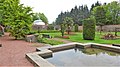 Belleisle Park, walled garden, South Ayrshire - pond.jpg 1,920 × 1,080; 836 KB
-
 Bellmoor Hill - geograph.org.uk - 5588114.jpg 2,592 × 1,728; 2.34 MB
-
 Bellmoor Hill - geograph.org.uk - 5964929.jpg 640 × 427; 72 KB
-
 Bennane Burn - geograph.org.uk - 4908444.jpg 3,504 × 2,336; 4.19 MB
-
 Bennane Burn meets the Sea - geograph.org.uk - 5512703.jpg 2,592 × 1,728; 2.67 MB
-
 Bennane Cave - geograph.org.uk - 5512736.jpg 2,592 × 1,728; 3.09 MB
-
 Bennane Cave - geograph.org.uk - 5512741.jpg 2,592 × 1,728; 2.94 MB
-
 Bennane Head - geograph.org.uk - 4444498.jpg 3,504 × 2,336; 4.63 MB
-
 Bennane Lea - geograph.org.uk - 5512697.jpg 2,592 × 1,728; 2.64 MB
-
 Bennane Lea - geograph.org.uk - 5512752.jpg 2,592 × 1,728; 2.86 MB
-
 Bennane Shore View - geograph.org.uk - 4384910.jpg 640 × 427; 82 KB
-
 Beside Drumshang Loch - geograph.org.uk - 1618161.jpg 640 × 451; 86 KB
-
 Beside The Interconnector - geograph.org.uk - 1299939.jpg 640 × 426; 133 KB
-
 Big Isle - geograph.org.uk - 5584220.jpg 2,592 × 1,728; 1.69 MB
-
 Big Isle - geograph.org.uk - 5584233.jpg 2,592 × 1,728; 1.63 MB
-
 Big Isle - geograph.org.uk - 5584234.jpg 2,592 × 1,728; 1.49 MB
-
 Big Isle - geograph.org.uk - 5584238.jpg 2,592 × 1,728; 2.55 MB
-
 Big Rock at Woodland Bay - geograph.org.uk - 5584593.jpg 2,592 × 1,728; 2.99 MB
-
 Billy Bridges Bar - geograph.org.uk - 1194836.jpg 640 × 480; 90 KB
-
 Black Neuk - geograph.org.uk - 5584581.jpg 2,592 × 1,728; 1.56 MB
-
 Boat leaving Dunure Harbour - geograph.org.uk - 6179754.jpg 2,976 × 1,984; 2.8 MB
-
 Bracken Bay - geograph.org.uk - 3551521.jpg 640 × 437; 94 KB
-
 Bracken Bay at Heads of Ayr - geograph.org.uk - 2819409.jpg 640 × 450; 98 KB
-
 Bridge over the Pow Burn - geograph.org.uk - 1672279.jpg 640 × 425; 53 KB
-
 Bridge, River Doon - geograph.org.uk - 4400892.jpg 800 × 600; 380 KB
-
 Broad Sands view - geograph.org.uk - 6255786.jpg 640 × 419; 84 KB
-
 Broadhirst Farm cottage.JPG 2,288 × 1,712; 1.4 MB
-
 Burn meets the Sea - geograph.org.uk - 3350570.jpg 2,272 × 1,704; 692 KB
-
 Burns and Highland Mary Memorial from Failford.JPG 4,608 × 3,456; 3.64 MB
-
 By Shallochwreck Burn - geograph.org.uk - 470294.jpg 640 × 460; 88 KB
-
 By The River Ayr - geograph.org.uk - 1126713.jpg 640 × 426; 145 KB
-
 Bynehill Girvan 01.jpg 6,016 × 3,010; 4.03 MB
-
 Bynehill Girvan 02.jpg 6,016 × 3,011; 4.16 MB
-
 Bynehill Girvan 03.jpg 5,799 × 3,857; 3.85 MB
-
 Bynehill Girvan 04.jpg 6,016 × 4,000; 5.66 MB
-
 Bynehill Girvan 05.jpg 6,016 × 4,000; 6.3 MB
-
 Carleton Hill - geograph.org.uk - 5584231.jpg 2,592 × 1,728; 1.86 MB
-
 Carleton Shore - geograph.org.uk - 5584228.jpg 2,592 × 1,728; 559 KB
-
 Carrick Drive, Crosshill - geograph.org.uk - 1196833.jpg 640 × 409; 71 KB
-
 Carsloe Farm - geograph.org.uk - 258360.jpg 640 × 480; 132 KB
-
 Cattle Grid - geograph.org.uk - 377780.jpg 640 × 471; 136 KB
-
 Cattle near Dalcur - geograph.org.uk - 334600.jpg 640 × 480; 56 KB
-
 Cattle near Ladyburn - geograph.org.uk - 334599.jpg 640 × 480; 68 KB
-
 Cave at Culzean - geograph.org.uk - 5050685.jpg 1,920 × 1,280; 596 KB
-
 Cave at Culzean - geograph.org.uk - 5050701.jpg 1,920 × 1,280; 2.14 MB
-
 Caves Below the Castle - geograph.org.uk - 5050712.jpg 1,920 × 1,280; 2.07 MB
-
 Changue Forest View - geograph.org.uk - 1236919.jpg 640 × 426; 103 KB
-
 Chapelton Burn - geograph.org.uk - 3350676.jpg 2,272 × 1,704; 682 KB
-
 Chirmorrie - geograph.org.uk - 896567.jpg 640 × 428; 108 KB
-
 Clear Fell - geograph.org.uk - 377765.jpg 640 × 480; 168 KB
-
 Clear Fell At Shalloch On Minnoch - geograph.org.uk - 1463265.jpg 640 × 426; 103 KB
-
 Clear Fell Close Up - geograph.org.uk - 826706.jpg 450 × 600; 96 KB
-
 Clear fell near Ferter - geograph.org.uk - 897072.jpg 640 × 480; 82 KB
-
 Clear Fell Near Loch Riecawr - geograph.org.uk - 1063485.jpg 640 × 426; 122 KB
-
 Cliff north of Currarie Port - geograph.org.uk - 4959951.jpg 1,600 × 1,067; 693 KB
-
 Cliffs at Culzean Castle - geograph.org.uk - 5050721.jpg 1,920 × 1,280; 797 KB
-
 Cliffs Below David Bodan's Loup - geograph.org.uk - 5723397.jpg 640 × 444; 119 KB
-
 Clock Tower, Culzean - geograph.org.uk - 4815009.jpg 1,860 × 1,195; 306 KB
-
 Coast and Clouds - geograph.org.uk - 5916760.jpg 2,927 × 1,933; 912 KB
-
 Coast at Culzean Castle - geograph.org.uk - 6219563.jpg 2,976 × 1,984; 3.03 MB
-
 Coastline at Ayr - geograph.org.uk - 4094536.jpg 1,920 × 1,280; 1.34 MB
-
 Coastline at Carleton - geograph.org.uk - 5584225.jpg 2,592 × 1,728; 1.73 MB


_-_panoramio.jpg)
_-_panoramio.jpg)

.jpg)
.jpg)


.jpg)
.jpg)
.jpg)


.jpg)


_-_geograph.org.uk_-_2879064.jpg)


