Category:Csősztorony
Jump to navigation
Jump to search
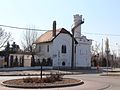
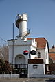
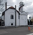
English: : Country/Vineyard guard tower planned by Lőrinc Zofahl (1844) After 1896 used as a police station. Now a pub/restaurant is here. - Gitár and Harmat streets cnr., Óhegy neighborhood, 10th District of Budapest.
Magyar: : Csősztorony jelenleg Harmat u. 31szám címmel a Csősztorony Bisztró müködik itt. - Budapest, Kőbánya, Óhegy negyed, Gitár utca és Harmat utca sarok
|
This is a category about a monument in Hungary. Identifier: 1080 |
| Object location | | View all coordinates using: OpenStreetMap |
|---|
 | |||||
| Upload media | |||||
| Named after |
| ||||
|---|---|---|---|---|---|
| Location | Óhegy, Budapest District X, Budapest, Hungary | ||||
| Architect | |||||
 | |||||
Media in category "Csősztorony"
The following 23 files are in this category, out of 23 total.
-
 Arch window, Guard tower(1844), Óhegy, 2018 Kőbánya.jpg 472 × 1,320; 240 KB
-
 Bifora, Guard tower(1844), Óhegy, 2018 Kőbánya.jpg 1,048 × 1,496; 440 KB
-
 Csosztorony Gitar1.jpg 1,131 × 1,530; 813 KB
-
 Csősztorony 001.JPG 2,063 × 2,754; 530 KB
-
 Csősztorony 002.JPG 1,791 × 2,393; 706 KB
-
 Csősztorony 003.JPG 3,002 × 2,256; 1.34 MB
-
 Csősztorony 01.JPG 680 × 1,024; 325 KB
-
 Csősztorony 02.JPG 678 × 1,024; 255 KB
-
 Csősztorony Bisztró, 2018 Kőbánya.jpg 2,128 × 1,616; 1.05 MB
-
 Csősztorony Bisztró, kerthelyiség, 2018 Kőbánya.jpg 1,704 × 2,272; 986 KB
-
 Csősztorony buszmegálló és körforgalom, 2018 Kőbánya.jpg 2,272 × 1,704; 930 KB
-
 Csősztorony és keerékpárút, 2018 Kőbánya.jpg 1,416 × 1,936; 839 KB
-
 Csősztorony és körforgalom, 2018 Kőbánya.jpg 1,704 × 2,272; 980 KB
-
 Csősztorony, csigalépcsős figyelőtorony, 2018 Kőbánya.jpg 1,704 × 2,272; 913 KB
-
 Csősztorony, nyugati felől, 2018 Kőbánya.jpg 1,704 × 2,272; 923 KB
-
 Csősztorony, pártázatos mellvédű terasz és figyelőtorony, 2018 Kőbánya.jpg 1,704 × 2,272; 977 KB
-
 Harmat utca 41. Csősztorony. Fortepan 18534.jpg 4,089 × 4,491; 6.06 MB
-
 Guard tower (1844), detail, 2018 Kőbánya.jpg 1,704 × 2,272; 1.02 MB
-
 Guard tower planned by Lőrinc Zofahl (1844), 2018 Kőbánya.jpg 1,704 × 2,272; 973 KB
-
 Kobanya csosztorony PA280327-1000.jpg 687 × 1,000; 51 KB
-
 Pinceablak, Csősztorony, 2018 Kőbánya.jpg 1,704 × 2,272; 996 KB
-
 Tour du garde champêtre, 2018 Kőbánya.jpg 1,672 × 1,784; 828 KB
-
 Windows, Guard tower(1844), Óhegy, 2018 Kőbánya.jpg 1,704 × 2,272; 1.03 MB
,_%C3%93hegy,_2018_K%C5%91b%C3%A1nya.jpg)


,_detail,_2018_K%C5%91b%C3%A1nya.jpg)
,_2018_K%C5%91b%C3%A1nya.jpg)


,_%C3%93hegy,_2018_K%C5%91b%C3%A1nya.jpg)
,_%C3%93hegy,_2018_K%C5%91b%C3%A1nya.jpg)