Category:Dangrek Mountains
Jump to navigation
Jump to search
Deutsch: Das Dongrek-Gebirge (auch: Dângrêk-Gebirge, Khmer: Chuor Phnom Dângrêk; Thai: ทิวเขาพนมดงรัก, Thiu Khao Phanom Dongrak) ist eine Bergkette entlang der Grenze zwischen Thailands Nordost-Region und Kambodscha.
English: The Dângrêk Mountains (Khmer: Chuor Phnom Dângrêk; Thai: ทิวเขาพนมดงรัก, Thiu Khao Phanom Dongrak), meaning "Carrying-Pole Mountains" in Khmer, is a mountain range forming a natural border between Cambodia and Thailand.
mountain range  | |||||
| Upload media | |||||
| Instance of | |||||
|---|---|---|---|---|---|
| Made from material | |||||
| Location |
| ||||
| Width |
| ||||
| Length |
| ||||
| Highest point |
| ||||
| Elevation above sea level |
| ||||
 | |||||
Subcategories
This category has the following 2 subcategories, out of 2 total.
K
T
Media in category "Dangrek Mountains"
The following 2 files are in this category, out of 2 total.
-
 Dangrek09.JPG 1,200 × 319; 54 KB
-
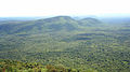 Dongrakfrommawidaeng1.jpg 2,528 × 1,412; 375 KB