Category:De Hoop, Bavel
Jump to navigation
Jump to search
| Object location | | View all coordinates using: OpenStreetMap |
|---|
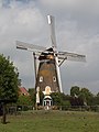
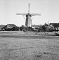
Nederlands: Afbeeldingen van de korenmolen De Hoop, Schoutenlaan 75, 4854 AV Bavel, behorende tot de gemeente Breda, in de provincie Noord-Brabant.
|
This is a category about rijksmonument number 30490
|
windmill in Bavel, Netherlands  | |||||
| Upload media | |||||
| Instance of | |||||
|---|---|---|---|---|---|
| Location | Bavel, Breda, North Brabant, Netherlands | ||||
| Street address |
| ||||
| Located on street |
| ||||
| Has use | |||||
| Heritage designation |
| ||||
| Inception |
| ||||
| Source of energy | |||||
 | |||||
Media in category "De Hoop, Bavel"
The following 21 files are in this category, out of 21 total.
-
 30490 windmolen de hoop.jpg 3,326 × 4,436; 8.1 MB
-
 Bavel molen De Hoop.jpg 1,400 × 2,100; 1.47 MB
-
 De Hoop, Bavel I82596.jpg 3,264 × 2,448; 3.53 MB
-
 De Hoop, Bavel I82597.jpg 2,448 × 3,264; 3.66 MB
-
 De Hoop, Bavel P1330670.jpg 2,672 × 4,000; 5.08 MB
-
 De Hoop, Bavel P1330671.jpg 2,672 × 4,000; 5.42 MB
-
 De Hoop, Bavel P1330672.jpg 4,000 × 2,672; 6.39 MB
-
 De Hoop, Bavel P1330673.jpg 2,672 × 4,000; 5.67 MB
-
 De Hoop, Bavel P1330674.jpg 4,000 × 2,672; 6.21 MB
-
 De Hoop, Bavel P1330675.jpg 2,672 × 4,000; 5.78 MB
-
 De Hoop, Bavel P1330677.jpg 2,672 × 4,000; 5.04 MB
-
 De Hoop, Bavel P1330678.jpg 4,000 × 2,672; 4.88 MB
-
 De Hoop, Bavel P1330681.jpg 2,672 × 4,000; 5.8 MB
-
 De Hoop, Bavel P1330682.jpg 4,000 × 2,672; 4.78 MB
-
 De Hoop, Bavel P1330683.jpg 4,000 × 2,672; 5.41 MB
-
 Informatiebord P1330686.jpg 4,000 × 2,672; 5.41 MB
-
 Korenmolen "De Hoop", aanzicht Kerkeind - Bavel - 20028645 - RCE.jpg 810 × 1,200; 189 KB
-
 Korenmolen "De Hoop", in restauratie - Bavel - 20028646 - RCE.jpg 1,200 × 1,181; 181 KB
-
 Korenmolen "De Hoop", in restauratie - Bavel - 20028647 - RCE.jpg 1,200 × 1,181; 228 KB
-
 Korenmolen De Hoop Bavel.jpg 3,024 × 4,032; 2.93 MB
-
 Overzicht windmolen - Bavel - 20346837 - RCE.jpg 1,185 × 1,200; 313 KB


