Category:Schoutenlaan, Bavel
Jump to navigation
Jump to search
| Object location | | View all coordinates using: OpenStreetMap |
|---|
Nederlands: Afbeeldingen van de lange straat de Schoutenlaan, Bavel in Bavel, behorende tot de gemeente Breda, in de provincie Noord-Brabant in het zuiden van Nederland. Onder meer bereikbaar vanaf de straat de Deken Dr. Dirckxweg en de Oude Bredaseweg. Nabij de korenmolen De Hoop
Subcategories
This category has the following 2 subcategories, out of 2 total.
H
- De Hoop, Bavel (21 F)
S
- Speelplaats Schoutenlaan (10 F)
Media in category "Schoutenlaan, Bavel"
The following 9 files are in this category, out of 9 total.
-
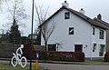 Schoutenlaan 58, Bavel P1330684 copy 2.jpg 2,327 × 1,494; 864 KB
-
 Schoutenlaan 70, Bavel P1330676 copy.jpg 3,860 × 2,166; 1.7 MB
-
 Schoutenlaan, Bavel P1330684 copy.jpg 3,901 × 2,014; 1.9 MB
-
 Schoutenlaan, Bavel P1330687 copy.jpg 4,000 × 1,327; 1.57 MB
-
 Schoutenlaan, Bavel P1330688 copy.jpg 4,000 × 1,676; 1.6 MB
-
 Schoutenlaan, Bavel P1330690 copy.jpg 4,000 × 1,873; 1.81 MB
-
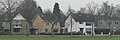 Schoutenlaan, Bavel P1330691 copy.jpg 4,000 × 1,349; 1.05 MB
-
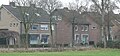
 Woningen P1330691 copy 1.jpg 1,987 × 1,071; 445 KB
-
 Woningen P1330691 copy 2.jpg 1,915 × 916; 355 KB


