Category:Deseret Relief Society Hall (Deseret, Utah)
Jump to navigation
Jump to search
| Object location | | View all coordinates using: OpenStreetMap |
|---|
community center in Millard County, Utah  | |||||
| Upload media | |||||
| Instance of | |||||
|---|---|---|---|---|---|
| Location | Deseret, Millard County, Utah | ||||
| Street address |
| ||||
| Heritage designation |
| ||||
| Inception |
| ||||
 | |||||
Media in category "Deseret Relief Society Hall (Deseret, Utah)"
The following 7 files are in this category, out of 7 total.
-
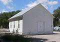
 Deseret Relief Society Hall from NW 1.JPG 1,771 × 1,306; 432 KB
-
 Deseret Relief Society Hall from NW 2.JPG 2,151 × 1,249; 541 KB
-
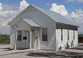
 Deseret Relief Society Hall from SE 1.JPG 1,914 × 1,337; 510 KB
-
 Deseret Relief Society Hall from SW 1.JPG 2,114 × 1,476; 569 KB
-
 Deseret Relief Society Hall from W 1.JPG 1,934 × 1,673; 587 KB
-
 Deseret Relief Society Hall outhouse from NW 1.JPG 1,224 × 1,446; 417 KB
-
 Deseret Relief Society Hall outhouse from SW 1.JPG 1,285 × 1,408; 393 KB


