Category:Dinagat Islands
Jump to navigation
Jump to search
- Provinces of the Philippines Abra · Agusan del Norte · Agusan del Sur · Aklan · Albay · Antique · Apayao · Aurora · Basilan · Bataan · Batanes · Batangas · Benguet · Biliran · Bohol · Bukidnon · Bulacan · Cagayan · Camarines Norte · Camarines Sur · Camiguin · Capiz · Catanduanes · Cavite · Cebu · Cotabato · Davao de Oro · Davao del Norte · Davao del Sur · Davao Occidental · Davao Oriental · Dinagat Islands · Eastern Samar · Guimaras · Ifugao · Ilocos Norte · Ilocos Sur · Iloilo · Isabela · Kalinga · La Union · Laguna · Lanao del Norte · Lanao del Sur · Leyte · Maguindanao del Norte · Marinduque · Masbate · Misamis Occidental · Misamis Oriental · Mountain Province · Negros Occidental · Negros Oriental · Northern Samar · Nueva Ecija · Nueva Vizcaya · Occidental Mindoro · Oriental Mindoro · Palawan · Pampanga · Pangasinan · Quezon · Quirino · Rizal · Romblon · Samar · Sarangani · Siquijor · Sorsogon · South Cotabato · Southern Leyte · Sultan Kudarat · Sulu · Surigao del Norte · Surigao del Sur · Tarlac · Tawi-Tawi · Zambales · Zamboanga del Norte · Zamboanga del Sur · Zamboanga Sibugay ·
- Province-level divisions (independent cities, Metro Manila) Angeles City · Bacolod · Baguio · Cagayan de Oro · Cebu City · Cotabato City · Dagupan · Davao City · General Santos · Iligan · Iloilo City · Lapu-Lapu City · Lucena · Mandaue · Metro Manila · Naga · Olongapo · Ormoc · Puerto Princesa · Tacloban · Zamboanga City ·
English: The Dinagat Islands archipelago is a province of the Philippines within the Caraga Region, in the Mindanao islands group area.
province of the Philippines .jpg)   | |||||
| Upload media | |||||
| Instance of | |||||
|---|---|---|---|---|---|
| Location | Caraga, PH | ||||
| Located in or next to body of water | |||||
| Capital | |||||
| Head of government |
| ||||
| Inception |
| ||||
| Population |
| ||||
| Area |
| ||||
| Electorate |
| ||||
| official website | |||||
 | |||||
Subcategories
This category has the following 2 subcategories, out of 2 total.
D
- Maps of Dinagat Islands (1 P, 15 F)
Media in category "Dinagat Islands"
The following 6 files are in this category, out of 6 total.
-
 360° view of White Beach, Dinagat.jpg 8,704 × 4,352; 6.34 MB
-
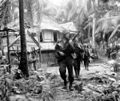 6th Ranger Battalion, 1944.jpg 650 × 548; 175 KB
-
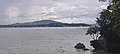 Dinagat-poblacion-viewed-from-la-isla-calavera.jpg 4,624 × 2,080; 3.55 MB
-
 Ichthyodes biguttula dinagatensis Breuning (2872659794).jpg 2,661 × 1,085; 627 KB
-
 Nepenthes bellii upper pitcher.jpg 2,068 × 3,029; 1.67 MB
-
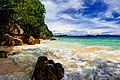 The hidden paradise of Dinagat Island.jpg 5,664 × 3,792; 6.26 MB


.jpg)