Category:Dunadd
Jump to navigation
Jump to search
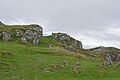
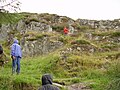
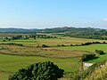
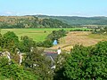
English: Dunadd is an Iron Age hillfort near Kilmartin in Argyll and Bute. Atlas of Hillforts number 2466
hill fort in Argyll and Bute, Scotland, UK  Dunadd Hillfort Crag | |||||
| Upload media | |||||
| Instance of | |||||
|---|---|---|---|---|---|
| Location |
| ||||
| Heritage designation |
| ||||
 | |||||
Media in category "Dunadd"
The following 63 files are in this category, out of 63 total.
-
 A bend in the River Add - geograph.org.uk - 940502.jpg 640 × 480; 67 KB
-

-
 Abandoned meander, River Add - geograph.org.uk - 1712089.jpg 640 × 480; 66 KB
-
 Car park at Dunadd - geograph.org.uk - 941382.jpg 640 × 480; 106 KB
-
 Cricket pitch, Dunadd - geograph.org.uk - 941361.jpg 640 × 480; 111 KB
-
 Dunadd - geograph.org.uk - 421315.jpg 640 × 437; 111 KB
-
 Dunadd - the 'inner fort' - geograph.org.uk - 421337.jpg 640 × 443; 135 KB
-
 Dunadd - the entrance - geograph.org.uk - 421327.jpg 640 × 422; 199 KB
-
 Dunadd Approach - geograph.org.uk - 1032595.jpg 640 × 427; 46 KB
-
 Dunadd Fort - view.jpg 700 × 471; 126 KB
-
 Dunadd Fort 20080427 - entry to upper levels.jpg 535 × 800; 188 KB
-
 Dunadd Fort 20080427 - footprint.jpg 700 × 442; 157 KB
-
 Dunadd Fort 20080427 - highest level.jpg 800 × 535; 215 KB
-
 Dunadd Fort 20080427 - well.jpg 700 × 500; 233 KB
-
 Dunadd Fort 20080427.jpg 800 × 477; 136 KB
-
 Dunadd Fort and the view north - geograph.org.uk - 941347.jpg 640 × 480; 103 KB
-
 Dunadd Fort Basin and Footprint.png 768 × 1,024; 1.74 MB
-
 Dunadd Fort Climb.jpg 768 × 1,024; 431 KB
-
 Dunadd Fort path.jpg 4,032 × 3,024; 2.9 MB
-
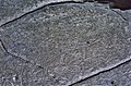 Dunadd Fort Pictish type boar carving.jpg 1,799 × 1,182; 734 KB
-
 Dunadd Fort sign.jpg 4,032 × 3,024; 2.68 MB
-
 Dunadd Fort, Kilmartin - geograph.org.uk - 1498.jpg 409 × 547; 77 KB
-
 Dunadd Fort.jpg 4,032 × 3,024; 1.8 MB
-
 Dunadd Hill Fort - geograph.org.uk - 1410539.jpg 640 × 480; 52 KB
-
 Dunadd Inauguration stone.jpg 3,664 × 5,392; 12.01 MB
-
 Dunadd River Add seen from the bridge downstream.jpg 4,000 × 6,000; 13.13 MB
-
 Dunadd River Add seen from the top.jpg 6,000 × 4,000; 11.29 MB
-
 Dunadd Rocks on the hillside 1.jpg 6,000 × 4,000; 13.65 MB
-
 Dunadd Rocks on the hillside 2.jpg 6,000 × 4,000; 15.44 MB
-
 Dunadd View from the hill to the southeast.jpg 6,000 × 4,000; 11.7 MB
-
 Dunadd View from the top to the northeast.jpg 6,000 × 4,000; 13.02 MB
-
 Dunadd View from the top to the southwest.jpg 6,000 × 4,000; 11.11 MB
-
 Dunadd View from the top to the west.jpg 5,880 × 3,856; 10.76 MB
-
 Dunadd, Argyll - geograph.org.uk - 876835.jpg 640 × 480; 62 KB
-
 Dunadd, Argyll - geograph.org.uk - 941377.jpg 640 × 480; 90 KB
-
 Dunadd, Argyll.jpg 4,896 × 3,672; 6.7 MB
-
 Dunadd, Kilmartin - geograph.org.uk - 381047.jpg 640 × 425; 62 KB
-
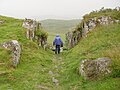 Dunadd-Hillfort-CarvedPathway.JPG 2,560 × 1,920; 1.21 MB
-
 Dunadd-Hillfort-DescriptiveAndMap.jpg 2,560 × 1,920; 1.24 MB
-
 Dunadd-Hillfort-MidlevelApproach.JPG 2,560 × 1,920; 1.21 MB
-
 Dunnad Hill - Scotland - panoramio.jpg 3,872 × 2,592; 3.95 MB
-
 Former course of the River Add - geograph.org.uk - 941356.jpg 640 × 480; 77 KB
-
 Houses at Dunadd - geograph.org.uk - 941387.jpg 640 × 480; 85 KB
-

-

-
 Drawing of carving at Dunadd Fort Argyle. A. Wellcome M0001167.jpg 1,493 × 1,126; 177 KB
-
 Drawing of carving at Dunadd Fort Argyle. B. Wellcome M0001168.jpg 1,441 × 1,168; 394 KB
-
 Drawing of carving at Dunadd Fort Argyle. C. Wellcome M0001169.jpg 1,502 × 1,124; 234 KB
-
 Pathway to our origins - geograph.org.uk - 876839.jpg 640 × 480; 63 KB
-
 River Add from Dunadd - geograph.org.uk - 476805.jpg 640 × 427; 59 KB
-
 Rocky outcrop, Dunadd Fort - geograph.org.uk - 940504.jpg 640 × 480; 144 KB
-
 Scotland Dunadd 1.jpg 1,248 × 1,008; 394 KB
-
 Scotland Dunadd.jpg 1,248 × 1,008; 222 KB
-
 Summit of Dunadd - geograph.org.uk - 1410546.jpg 640 × 480; 77 KB
-
 The Anointing Stoup, Dunadd Fort - geograph.org.uk - 940506.jpg 640 × 480; 163 KB
-
 The descent from Dunadd Fort - geograph.org.uk - 940505.jpg 640 × 480; 100 KB
-
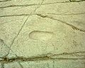
 The Footprint of Fealty, Dunadd Fort - geograph.org.uk - 940508.jpg 640 × 480; 137 KB
-
 The gate to Dunadd Fort - geograph.org.uk - 941371.jpg 640 × 480; 140 KB
-
 The River Add - geograph.org.uk - 941393.jpg 640 × 480; 115 KB
-
 The River Add - geograph.org.uk - 941400.jpg 640 × 480; 88 KB
-
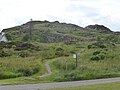
 View of Dunadd hill fort from A816 - geograph.org.uk - 502486.jpg 640 × 428; 67 KB
-
 ViewFromDunadd1-Scotland-HypeNapungra.jpg 3,296 × 2,472; 1.43 MB
-
 ViewFromDunadd2-HypeNapungra.jpg 2,080 × 3,296; 1.34 MB


