Category:Dungeon culvert
Jump to navigation
Jump to search
| Object location | | View all coordinates using: OpenStreetMap |
|---|
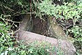
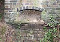
This culvert lies just off the Wirral Way on its north side at the turnoff of the footpath to The Dungeon. It is southeast of Dungeon bridge
Subcategories
This category has only the following subcategory.
B
- Benchmark at Dungeon culvert (2 F)
Media in category "Dungeon culvert"
The following 5 files are in this category, out of 5 total.
-
 Dungeon culvert 1.jpg 5,184 × 3,456; 13.57 MB
-
 Dungeon culvert 2.jpg 5,184 × 3,456; 11.71 MB
-
 Dungeon culvert 3.jpg 5,008 × 3,320; 11.09 MB
-
 Dungeon culvert 4.jpg 4,700 × 3,212; 9.88 MB
-
 Subsidiary channel, Dungeon culvert.jpg 4,124 × 2,852; 7.57 MB


