Category:Ehemalige Komturei, Köniz
Jump to navigation
Jump to search
| Object location | | View all coordinates using: OpenStreetMap |
|---|
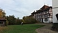
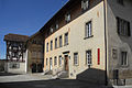
architectural ensemble with castle, church and outbuildings in Köniz in the canton of Bern, Switzerland  | |||||
| Upload media | |||||
| Instance of | |||||
|---|---|---|---|---|---|
| Part of | |||||
| Location | Köniz, Bern-Mittelland administrative district, Bernese Mittelland administrative region, Bern, Switzerland | ||||
| Street address |
| ||||
| Has part(s) |
| ||||
| Heritage designation | |||||
 | |||||
Subcategories
This category has only the following subcategory.
S
- St. Peter und Paul (Köniz) (30 F)
Media in category "Ehemalige Komturei, Köniz"
The following 41 files are in this category, out of 41 total.
-
 CH-NB - Köniz - Collection Gugelmann - GS-GUGE-WEIBEL-D-67a.tif 5,700 × 4,045, 2 pages; 34.35 MB
-
 CH-NB - Köniz - Collection Gugelmann - GS-GUGE-WEIBEL-D-67b.tif 5,700 × 3,887, 2 pages; 35.51 MB
-
 CH-NB - Köniz, Kirche und Schloss - Collection Gugelmann - GS-GUGE-NÖTHIGER-F-28.tif 4,994 × 3,313, 2 pages; 47.36 MB
-
 CH-NB - Köniz, Schloss und Kirche - Collection Gugelmann - GS-GUGE-NÖTHIGER-F-59.tif 4,750 × 3,116, 2 pages; 42.37 MB
-
 Koeniz Schloss.jpg 3,482 × 2,487; 2.13 MB
-
 Kulturhof Schloss Köniz.JPG 4,000 × 3,000; 6.86 MB
-
 Köniz ehemalige Komturei Kirche DSC05294.jpg 2,248 × 4,000; 2.33 MB
-
 Köniz ehemalige Komturei Kirche DSC05300.jpg 2,949 × 2,210; 1.91 MB
-
 Köniz ehemalige Komturei Kirche DSC05303.jpg 3,000 × 4,000; 3.51 MB
-
 Köniz ehemalige Komturei Kornhaus DSC05299.jpg 4,000 × 2,248; 2.77 MB
-
 Köniz ehemalige Komturei Ritterhaus DSC05318.jpg 3,417 × 2,561; 2.48 MB
-
 Köniz-Schloss.jpg 4,000 × 3,000; 4.99 MB
-
 Schloss Köniz - Kirche.JPG 4,000 × 3,447; 6.31 MB
-
 Schloss Köniz DSC05838.jpg 4,000 × 2,672; 3.25 MB
-
 Schloss Köniz DSC05839.jpg 4,000 × 2,672; 2.42 MB
-
 Schloss Köniz DSC05840.jpg 3,473 × 2,412; 2.16 MB
-
 Schloss Köniz DSC05841.jpg 2,324 × 3,616; 4.3 MB
-
 Schloss Köniz DSC05855.jpg 4,000 × 2,672; 3.32 MB
-
 Schloss Köniz DSC05858.jpg 4,000 × 2,248; 2.72 MB
-
 Schloss Köniz DSC05859.jpg 2,672 × 4,000; 2.93 MB
-
 Schloss Köniz Hof.JPG 4,000 × 2,412; 4.58 MB
-
 Schloss Köniz in 01.jpg 4,128 × 2,322; 3.04 MB
-
 Schloss Köniz in 02.jpg 4,128 × 2,322; 4.04 MB
-
 Schloss Köniz in 03.jpg 4,005 × 2,253; 1.81 MB
-
 Schloss Köniz in 04.jpg 4,128 × 2,322; 1.89 MB
-
 Schloss Köniz in 05.jpg 4,073 × 2,121; 2 MB
-
 Schloss Köniz in 06.jpg 4,128 × 2,322; 1.81 MB
-
 Schloss Köniz in 07.jpg 4,128 × 2,322; 1.88 MB
-
 Schloss Köniz in 08.jpg 2,322 × 4,128; 2.07 MB
-
 Schloss Köniz in 09.jpg 4,128 × 2,322; 2.43 MB
-
 Schloss Köniz in 10.jpg 4,128 × 2,322; 2.85 MB
-
 Schloss Köniz in 11.jpg 2,322 × 4,128; 2.42 MB
-
 Schloss Köniz in 12.jpg 2,322 × 4,128; 1.92 MB
-
 Schloss Köniz in 13.jpg 2,322 × 4,128; 1.95 MB
-
 Schloss Köniz in 14.jpg 2,322 × 4,128; 1.94 MB
-
 Schloss Köniz in 15.jpg 2,322 × 4,128; 1.42 MB
-
 Schloss Köniz in 17.jpg 2,322 × 4,128; 1.86 MB
-
 Schloss Köniz in 18.jpg 4,005 × 2,253; 1.5 MB
-
 Schloss Köniz mit Kirche.JPG 4,000 × 3,000; 4.98 MB
-
 Schloss Köniz.JPG 4,000 × 2,663; 4.39 MB
-
 SVB05wiki.jpg 640 × 480; 43 KB


