Category:Election maps of Karnataka
Jump to navigation
Jump to search
States of India: Andhra Pradesh · Arunachal Pradesh · Assam · Bihar · Chhattisgarh · Goa · Gujarat · Haryana · Himachal Pradesh · Jharkhand · Karnataka · Kerala · Madhya Pradesh · Maharashtra · Manipur · Meghalaya · Mizoram · Nagaland · Odisha · Punjab · Rajasthan · Sikkim · Tamil Nadu · Telangana · Tripura · Uttar Pradesh · Uttarakhand · West Bengal
Union territories: Andaman and Nicobar Islands · Chandigarh · Dadra and Nagar Haveli and Daman and Diu · Delhi · Jammu and Kashmir · Ladakh · Puducherry
Former states of India: Jammu and Kashmir ·
Former union territories:
Union territories: Andaman and Nicobar Islands · Chandigarh · Dadra and Nagar Haveli and Daman and Diu · Delhi · Jammu and Kashmir · Ladakh · Puducherry
Former states of India: Jammu and Kashmir ·
Former union territories:
Subcategories
This category has the following 2 subcategories, out of 2 total.
Media in category "Election maps of Karnataka"
The following 11 files are in this category, out of 11 total.
-
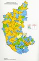
 2004 Karnataka Legislative Assembly election results - 1.jpg 561 × 726; 190 KB
-
 2008 Karnataka Assembly election Results.pdf 1,012 × 1,572; 218 KB
-
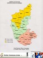 2008 Karnataka Assembly election Schedule - Districts.pdf 1,212 × 1,625; 406 KB
-
 2008 Karnataka Election Result 2008.png 5,133 × 5,458; 2.04 MB
-
 2013 Karnataka Election.svg 512 × 672; 243 KB
-
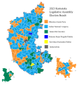
 2018 Karnataka Legislative Assembly Election Result Map.svg 1,232 × 1,310; 2.15 MB
-
 2023 Karnataka Election Result 2023.svg 1,232 × 1,310; 2.11 MB
-
 2023 Karnataka Legislative Assembly Election Result Map.svg 1,232 × 1,310; 2.12 MB
-
 Bangalore South Constituencies.gif 425 × 307; 12 KB
-
 Karnataka election, 2018 (Tamil).png 1,306 × 1,766; 347 KB
-
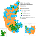 Karnataka election, 2018.png 1,234 × 1,262; 427 KB


.png)
