Category:Election maps of Meghalaya
Jump to navigation
Jump to search
States of India: Andhra Pradesh · Arunachal Pradesh · Assam · Bihar · Chhattisgarh · Goa · Gujarat · Haryana · Himachal Pradesh · Jharkhand · Karnataka · Kerala · Madhya Pradesh · Maharashtra · Manipur · Meghalaya · Mizoram · Nagaland · Odisha · Punjab · Rajasthan · Sikkim · Tamil Nadu · Telangana · Tripura · Uttar Pradesh · Uttarakhand · West Bengal
Union territories: Andaman and Nicobar Islands · Chandigarh · Dadra and Nagar Haveli and Daman and Diu · Delhi · Jammu and Kashmir · Puducherry
Former states of India: Jammu and Kashmir ·
Former union territories:
Union territories: Andaman and Nicobar Islands · Chandigarh · Dadra and Nagar Haveli and Daman and Diu · Delhi · Jammu and Kashmir · Puducherry
Former states of India: Jammu and Kashmir ·
Former union territories:
Media in category "Election maps of Meghalaya"
The following 7 files are in this category, out of 7 total.
-
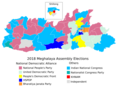 2018 Meghalaya assembly elections results.png 1,144 × 841; 177 KB
-
 2019 Lok Sabha in Meghalaya.svg 1,102 × 512; 232 KB
-
 2023 Meghalaya Legislative Assembly Election Results.png 1,102 × 512; 174 KB
-
 2024 Lok Sabha NDA Seat Sharing Meghalaya.svg 551 × 256; 305 KB
-
 Meghalaya Lok Sabha election result 2019.png 720 × 332; 36 KB
-
 Meghalaya Wahlkreise Lok Sabha 2024 Results.png 800 × 372; 50 KB
-
 Meghimn.png 300 × 139; 12 KB


