Category:Farms in Texel
Jump to navigation
Jump to search
| NO WIKIDATA ID FOUND! Search for Farms in Texel on Wikidata | |
| Upload media |
Subcategories
This category has the following 5 subcategories, out of 5 total.
Media in category "Farms in Texel"
The following 157 files are in this category, out of 157 total.
-
 De Cocksdorp Postweg 119-121.jpg 5,816 × 3,768; 16.06 MB
-
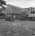 Houten schuur ( voormalig wierschuurcomplex) - Oudeschild - 20179415 - RCE.jpg 1,188 × 1,200; 404 KB
-
 Houten skelet, aanzicht - Oudeschild - 20179442 - RCE.jpg 1,200 × 804; 205 KB
-
 Oosterend, de Overtoom IMG 6070 2020-06-07 13.23.jpg 5,344 × 3,152; 10.47 MB
-
 PBK, uitg. HZA - De Waal - 20514056 - RCE.jpg 1,200 × 900; 158 KB
-
 Texel - De Grie - Havensluis - View SE.jpg 6,048 × 4,032; 19.57 MB
-
 Texel - De Grie - Havensluis - View South.jpg 5,932 × 3,954; 16.31 MB
-
 Texel - De Grie - ICE Photocompilation Viewing from WNW to East.jpg 7,439 × 2,168; 17.97 MB
-
 Texel - De Grie - ICE Photocompilation Viewing from WNW to ESE.jpg 7,449 × 2,144; 15.78 MB
-
 Texel - De Grie - July 2010 01.jpg 6,040 × 4,026; 20.27 MB
-

-

-
 Texel - De Grie - V.O.C. Harbour of Den Hoorn reconstructed in 2008 - July 2010 01.jpg 5,962 × 3,974; 19.75 MB
-
 Texel - De Grie - V.O.C. Harbour of Den Hoorn reconstructed in 2008 - July 2010 06.jpg 5,992 × 3,994; 22.81 MB
-
 Texel - De Grie - View East I.jpg 6,040 × 4,026; 18.88 MB
-
 Texel - De Grie - View East II.jpg 6,040 × 4,026; 19.48 MB
-

-
 Texel - De Grie - View East.jpg 5,932 × 3,954; 23.6 MB
-
 Texel - De Grie - View ENE II.jpg 6,040 × 4,026; 23.02 MB
-
 Texel - De Grie - View ENE III.jpg 5,992 × 3,994; 24.74 MB
-
 Texel - De Grie - View ENE.jpg 6,040 × 4,026; 19.26 MB
-
 Texel - De Grie - View ESE I.jpg 6,040 × 4,026; 21.05 MB
-
 Texel - De Grie - View ESE II.jpg 6,040 × 4,026; 22.21 MB
-
 Texel - De Grie - View NE I.jpg 5,916 × 3,944; 20.14 MB
-
 Texel - De Grie - View NE II.jpg 6,040 × 4,026; 20.57 MB
-
 Texel - De Grie - View NE.jpg 5,932 × 3,954; 22.36 MB
-
 Texel - De Grie - View NNE II.jpg 6,040 × 4,026; 22.87 MB
-
 Texel - De Grie - View NNE.jpg 5,962 × 3,974; 23.06 MB
-
 Texel - De Grie - View NNW II.jpg 6,040 × 4,026; 21.92 MB
-
 Texel - De Grie - View NNW.jpg 5,916 × 3,944; 19.81 MB
-
 Texel - De Grie - View North II.jpg 5,992 × 3,994; 22.03 MB
-
 Texel - De Grie - View North.jpg 6,040 × 4,026; 20.88 MB
-
 Texel - De Grie - View NW III.jpg 6,024 × 4,016; 21 MB
-
 Texel - De Grie - View NW.jpg 5,932 × 3,954; 20.33 MB
-
 Texel - De Grie - View SSW on Havensluis.jpg 5,902 × 3,934; 24.44 MB
-
 Texel - De Grie - View WNW II.jpg 6,040 × 4,026; 19.92 MB
-
 Texel - De Grie - View WNW.jpg 5,932 × 3,954; 19 MB
-
 Texel - De Groe - V.O.C. Harbour of Den Hoorn reconstructed in 2008 - July 2010 02.jpg 5,932 × 3,954; 19.85 MB
-
 Texel - De Groe - V.O.C. Harbour of Den Hoorn reconstructed in 2008 - July 2010 03.jpg 5,902 × 3,934; 19.44 MB
-
 Texel - De Groe - V.O.C. Harbour of Den Hoorn reconstructed in 2008 - July 2010 04.jpg 5,886 × 3,924; 21.95 MB
-
 Texel - De Groe - V.O.C. Harbour of Den Hoorn reconstructed in 2008 - July 2010 05.jpg 5,992 × 3,994; 21.87 MB
-
 Texel - De Groe - V.O.C. Harbour of Den Hoorn reconstructed in 2008 - July 2010 07.jpg 5,691 × 2,226; 13.2 MB
-
 Texel - De Hoge Berg - Doolhof - View SE towards Zeemanskerkje Oudeschild - February 2011 01.jpg 6,040 × 4,026; 27.24 MB
-
 Texel - De Slufter - View ESE - February 2011 01.jpg 5,886 × 3,924; 24.09 MB
-
 Texel - Den Hoorn - Lagewegje - View NNW.jpg 5,902 × 3,934; 24.84 MB
-
 Texel - Den Hoorn - Lagewegje - View North II.jpg 5,800 × 3,866; 23.87 MB
-
 Texel - Den Hoorn - Molwerk - Panorama View over the 'old land' of Texel 01.jpg 5,713 × 2,158; 13.61 MB
-
 Texel - Den Hoorn - Molwerk - Panorama View over the 'old land' of Texel 02.jpg 5,951 × 3,967; 21.62 MB
-
 Texel - Den Hoorn - Molwerk - Panorama View over the 'old land' of Texel 03.jpg 5,862 × 3,907; 20.17 MB
-
 Texel - Den Hoorn - Molwerk - Panorama View over the 'old land' of Texel 04.jpg 5,789 × 3,858; 19.83 MB
-
 Texel - Den Hoorn - Molwerk - Panorama View over the 'old land' of Texel 05.jpg 5,776 × 3,850; 19.39 MB
-
 Texel - Den Hoorn - Molwerk - Panorama View over the 'old land' of Texel 06.jpg 5,832 × 3,887; 20.68 MB
-

-
 Texel - Den Hoorn - Stolpweg - Bicyclepath - View NE.jpg 6,048 × 4,032; 27.38 MB
-
 Texel - Den Hoorn - Stolpweg - Bicyclepath - View NNE.jpg 5,784 × 3,856; 24.28 MB
-
 Texel - Den Hoorn - Stolpweg - Bicyclepath - View NNW towards Den Hoorn.jpg 5,800 × 3,866; 20.76 MB
-
 Texel - Den Hoorn - Stolpweg - Bicyclepath - View North I.jpg 5,688 × 3,792; 23.39 MB
-
 Texel - Fonteinsweg - ICE Photocompilation Viewing from SSE to WSW.jpg 3,482 × 2,006; 8.26 MB
-
 Texel - Fonteinsweg - View SSE towards Hoornder Kerkje.jpg 6,040 × 4,026; 25.59 MB
-
 Texel - Fonteinsweg - View SW.jpg 6,040 × 4,026; 21.06 MB
-
 Texel - Hoge Berg - Doolhof - Den Burg - February 2011 01.jpg 5,992 × 3,994; 26.49 MB
-
 Texel - Hoge Berg - Doolhof - View SSE - February 2011 01.jpg 5,886 × 3,924; 24.75 MB
-
 Texel - Hoge Berg - Schansweg - Lambing Season 2011 - March 01.jpg 5,815 × 2,018; 13.21 MB
-
 Texel - Hoge Berg - Schansweg - Lambing Season 2011 - March 02.jpg 5,976 × 3,984; 21.96 MB
-
 Texel - Hoge Berg - Schansweg - Lambing Season 2011 - March 03.jpg 6,040 × 4,026; 23.16 MB
-
 Texel - Hoge Berg - Schansweg - Lambing Season 2011 - March 04.jpg 6,040 × 4,026; 23.29 MB
-
 Texel - Hoge Berg - Schansweg - Lambing Season 2011 - March 05.jpg 5,826 × 3,884; 22.2 MB
-
 Texel - Hoge Berg - Schansweg - Lambing Season 2011 - March 06.jpg 5,856 × 3,904; 22.34 MB
-
 Texel - Hoge Berg - Schansweg - Lambing Season 2011 - March 07.jpg 6,064 × 4,032; 25.95 MB
-
 Texel - Hoge Berg - Schansweg - Lambing Season 2011 - March 08.jpg 5,872 × 3,914; 23.51 MB
-
 Texel - Hoge Berg - Schansweg - View East - Lambing Season 2011 - March.jpg 5,976 × 3,984; 23.75 MB
-
 Texel - Hoge Berg - Schansweg - View NNE - Lambing Season 2011 - March.jpg 5,902 × 3,934; 27.07 MB
-
 Texel - Hoge Berg - Schansweg - View NNW - Lambing Season 2011 - March.jpg 5,838 × 3,892; 22.79 MB
-

-

-

-

-

-

-

-

-

-

-

-

-

-
 Texel - Molwerk - De Petten - ICE Photocompilation Viewing from ENE to ENE 360°.jpg 10,240 × 2,321; 25.71 MB
-
 Texel - Molwerk - De Petten - ICE Photocompilation Viewing from South to South 360°.jpg 13,312 × 2,119; 30.79 MB
-
 Texel - Molwerk - De Petten - ICE Photocompilation Viewing from West to West 360°.jpg 10,240 × 2,321; 25.68 MB
-
 Texel - Molwerk - De Petten - View East on De Petten.jpg 6,006 × 4,004; 25.67 MB
-
 Texel - Molwerk - De Petten - View ENE on De Petten.jpg 6,039 × 4,026; 24.86 MB
-
 Texel - Molwerk - De Petten - View ENE.jpg 5,934 × 3,956; 25.29 MB
-
 Texel - Molwerk - De Petten - View NE II.jpg 5,994 × 3,995; 24.22 MB
-
 Texel - Molwerk - De Petten - View NE on De Petten.jpg 5,985 × 3,990; 24.22 MB
-
 Texel - Molwerk - De Petten - View NE.jpg 5,940 × 3,960; 25.49 MB
-
 Texel - Molwerk - De Petten - View NNE II.jpg 6,006 × 4,003; 23 MB
-
 Texel - Molwerk - De Petten - View NNE on De Petten.jpg 5,953 × 3,968; 23.59 MB
-
 Texel - Molwerk - De Petten - View NNE.jpg 6,024 × 4,016; 25.77 MB
-
 Texel - Molwerk - De Petten - View NNW II.jpg 5,976 × 3,984; 26.02 MB
-
 Texel - Molwerk - De Petten - View NNW III.jpg 5,991 × 3,994; 25.16 MB
-
 Texel - Molwerk - De Petten - View NNW towards Den Hoorn I.jpg 6,026 × 4,017; 25.73 MB
-
 Texel - Molwerk - De Petten - View NNW towards Den Hoorn II.jpg 6,042 × 4,027; 24.23 MB
-
 Texel - Molwerk - De Petten - View North towards Church of Den Hoorn II.jpg 6,007 × 4,004; 24.85 MB
-
 Texel - Molwerk - De Petten - View North towards Den Hoorn.jpg 5,887 × 3,924; 26.97 MB
-
 Texel - Molwerk - De Petten - View North towards Hoornder Kerkje I.jpg 5,994 × 3,995; 26.1 MB
-
 Texel - Molwerk - De Petten - View North towards Hoornder Kerkje II.jpg 5,971 × 3,980; 27.92 MB
-
 Texel - Molwerk - De Petten - View North towards Protestant Church of Den Hoorn.jpg 5,962 × 3,974; 25.25 MB
-
 Texel - Molwerk - De Petten - View North.jpg 5,966 × 3,977; 23.91 MB
-
 Texel - Okusweg - ICE Photocompilation Viewing from East to WSW.jpg 3,711 × 1,816; 7.05 MB
-
 Texel - Okusweg - ICE Photocompilation Viewing from NNW to South.jpg 6,326 × 1,873; 11.42 MB
-
 Texel - Okusweg - View East.jpg 5,920 × 3,946; 17.69 MB
-
 Texel - Okusweg - View ESE.jpg 5,992 × 3,994; 19.63 MB
-
 Texel - Okusweg - View SE.jpg 5,800 × 3,866; 18.86 MB
-
 Texel - Okusweg - View South II.jpg 5,886 × 3,924; 17.32 MB
-
 Texel - Okusweg - View SSE II.jpg 5,992 × 3,994; 19.71 MB
-
 Texel - Okusweg - View SSE towards Hoornder Kerkje.jpg 6,004 × 4,002; 18.16 MB
-
 Texel - Okusweg - View SSW I.jpg 5,920 × 3,946; 17.79 MB
-

-

-

-

-

-

-

-

-

-

-

-

-
 Texel - Watermolenweg - ICE Photocompilation Viewing from East to NW.jpg 9,105 × 2,063; 19.37 MB
-
 Texel - Watermolenweg - ICE Photocompilation Viewing from NW to East on Barley field.jpg 5,914 × 1,918; 14.13 MB
-
 Texel - Watermolenweg - ICE Photocompilation Viewing from SE to SW.jpg 5,881 × 1,943; 11.99 MB
-
 Texel - Watermolenweg - Near Havensluis - ICE Photocompilation Viewing from NW to East.jpg 6,126 × 1,900; 12.82 MB
-
 Texel - Watermolenweg - Near Havensluis - View East II.jpg 5,992 × 3,994; 22.36 MB
-
 Texel - Watermolenweg - Near Havensluis - View East.jpg 5,842 × 3,894; 21.98 MB
-
 Texel - Watermolenweg - Near Havensluis - View ENE.jpg 5,946 × 3,964; 22.62 MB
-
 Texel - Watermolenweg - Near Havensluis - View NE.jpg 6,048 × 4,032; 23.57 MB
-
 Texel - Watermolenweg - Near Havensluis - View NNE.jpg 6,048 × 4,032; 23.28 MB
-
 Texel - Watermolenweg - Near Havensluis - View North.jpg 5,842 × 3,894; 20.34 MB
-
 Texel - Watermolenweg - View East II.jpg 5,902 × 3,934; 23.73 MB
-
 Texel - Watermolenweg - View ENE III.jpg 5,976 × 3,984; 24.78 MB
-
 Texel - Watermolenweg - View NE III.jpg 6,024 × 4,016; 24.47 MB
-
 Texel - Watermolenweg - View NNE II.jpg 6,006 × 4,004; 26.61 MB
-
 Texel - Watermolenweg - View NNW III.jpg 5,758 × 3,838; 24.55 MB
-
 Texel - Watermolenweg - View North V.jpg 5,856 × 3,904; 25.81 MB
-
 Texel - Watermolenweg - View NW II.jpg 5,872 × 3,914; 24.81 MB
-
 Texel - Watermolenweg - View SSW II.jpg 5,962 × 3,974; 20.91 MB
-
 Texel - Watermolenweg - View SSW IV.jpg 5,902 × 3,934; 19.15 MB
-
 Texel - Watermolenweg - View SW II.jpg 5,932 × 3,954; 21.01 MB
-
 Texel - Watermolenweg - View SW III.jpg 5,946 × 3,964; 18.81 MB
-
 Texel - Watermolenweg - View SW IV.jpg 5,976 × 3,984; 18.59 MB
-
 Texel - Watermolenweg - View West II.jpg 5,992 × 3,994; 19.39 MB
-
 Texel - Watermolenweg - View WNW II.jpg 5,946 × 3,964; 19.47 MB
-
 Texel - Watermolenweg - View WSW II.jpg 5,902 × 3,934; 19.74 MB
-
 Texel - Watermolenweg - View WSW III.jpg 6,040 × 4,026; 18.12 MB
-
 Voormalige wierschuur verplaatst ca. 1930 - Oudeschild - 20179420 - RCE.jpg 1,192 × 1,200; 266 KB
-
 Woning en rechts gedeelte voormalige wierschuur - Oudeschild - 20179417 - RCE.jpg 1,186 × 1,200; 414 KB

_-_Oudeschild_-_20179415_-_RCE.jpg)


_Zandkes_(Natuurmonumenten)_%26_Wadden_Sea_02.jpg)
_Zandkes_(Natuurmonumenten)_%26_Wadden_Sea_03.jpg)
_Zandkes_(Natuurmonumenten)_%26_Wadden_Sea_04.jpg)
_Zandkes_(Natuurmonumenten)_%26_Wadden_Sea_05.jpg)
_Zandkes_(Natuurmonumenten)_%26_Wadden_Sea_06.jpg)
_Zandkes_(Natuurmonumenten)_%26_Wadden_Sea_07.jpg)
_Zandkes_(Natuurmonumenten)_%26_Wadden_Sea_08.jpg)
_Zandkes_(Natuurmonumenten)_%26_Wadden_Sea_09.jpg)
_Zandkes_(Natuurmonumenten)_%26_Wadden_Sea_10.jpg)
_Zandkes_(Natuurmonumenten)_%26_Wadden_Sea_11.jpg)
_Zandkes_(Natuurmonumenten)_%26_Wadden_Sea_12.jpg)
_Zandkes_(Natuurmonumenten)_%26_Wadden_Sea_13.jpg)


_-_Panorama_View_over_Prins_Hendrikpolder_02.jpg)
_-_Panorama_View_over_Prins_Hendrikpolder_03.jpg)
_-_Panorama_View_over_Prins_Hendrikpolder_04.jpg)
_-_Panorama_View_over_Prins_Hendrikpolder_05.jpg)
_-_Panorama_View_over_Prins_Hendrikpolder_06.jpg)
_-_Panorama_View_over_Prins_Hendrikpolder_07.jpg)
_-_Panorama_View_over_Prins_Hendrikpolder_08.jpg)
_-_Panorama_View_over_Prins_Hendrikpolder_09.jpg)
_-_Panorama_View_over_Prins_Hendrikpolder_10.jpg)
_-_Panorama_View_over_Prins_Hendrikpolder_11.jpg)
_-_Panorama_View_over_Prins_Hendrikpolder_12.jpg)


_Zandkes_(Natuurmonumenten)_%26_Wadden_Sea_01.jpg)
_-_Panorama_View_over_Prins_Hendrikpolder_01.jpg)