Category:Favrunbachtal (Eupen Kettenis)
Jump to navigation
Jump to search
| Object location | | View all coordinates using: OpenStreetMap |
|---|
protected landscape in Eupen, Belgium  | |||||
| Upload media | |||||
| Instance of | |||||
|---|---|---|---|---|---|
| Location | Kettenis, Eupen, Arrondissement of Verviers, Province of Liege, Walloon Region, Belgium | ||||
| Heritage designation |
| ||||
 | |||||
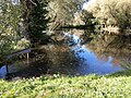
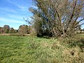
Deutsch: Umgebung des Baches. Feuchtgebiet mit bemerkenswertem Baumbestand. Geschützte Landschaft.
Français : Environs du ruisseau. Zone humide avec des arbres remarquables. Paysage protégé.
Nederlands: Omgeving van de beek. Wetland met opmerkelijke bomen. Beschermd landschap
English: Surroundings of the stream. Wetland with remarkable trees. Protected landscape.
|
This is a category about a monument of the German-speaking Community of Belgium, number: 31047
|
Media in category "Favrunbachtal (Eupen Kettenis)"
The following 9 files are in this category, out of 9 total.
-
 Favrunbachtal (1).jpg 4,651 × 2,618; 10.73 MB
-
 Favrunbachtal (2).jpg 3,638 × 1,458; 5.66 MB
-
 Favrunbachtal (3).jpg 4,032 × 3,024; 7.15 MB
-
 Favrunbachtal (4).jpg 4,032 × 3,024; 5.1 MB
-
 Favrunbachtal (5).jpg 4,032 × 3,024; 5.03 MB
-
 Favrunbachtal (6).jpg 4,032 × 3,024; 5.77 MB
-
 Favrunbachtal (7).jpg 4,032 × 3,024; 6.1 MB
-
 Favrunbachtal (8).jpg 4,032 × 3,024; 6.83 MB
-
 Favrunbachtal - Eupen.JPG 3,850 × 1,918; 3.53 MB
.jpg)
.jpg)
.jpg)
.jpg)
.jpg)
.jpg)
.jpg)
.jpg)