Category:Geography of Yaizu
Jump to navigation
Jump to search
日本語: 静岡県焼津市の地理。
Wikimedia category | |||||
| Upload media | |||||
| Instance of | |||||
|---|---|---|---|---|---|
| Category combines topics | |||||
| geography | |||||
science that studies the terrestrial surface, the societies that inhabit it and the territories, landscapes, places or regions that form it when interacting with each other     | |||||
| Pronunciation audio | |||||
| Instance of |
| ||||
| Different from | |||||
| Partially coincident with | |||||
| Yaizu | |||||
city in Shizuoka Prefecture, Japan .jpg)        | |||||
| Instance of | |||||
| Location |
| ||||
| Located in or next to body of water | |||||
| Legal form |
| ||||
| Inception |
| ||||
| Population |
| ||||
| Area |
| ||||
| Replaces |
| ||||
| official website | |||||
 | |||||
Subcategories
This category has the following 17 subcategories, out of 17 total.
A
- Asakusa Street (Yaizu) (3 F)
E
- Ekimae Street (Yaizu) (12 F)
H
- Honmachi Minami Park (4 F)
I
- Ishizu Beach (2 F)
J
- Jinmu Street (16 F)
K
- Mount Kokuzo (Shizuoka) (3 F)
- Kuroishi River (2 F)
M
O
- Ōkuzure Coast (27 F)
P
S
- Seto River (11 F)
- Showa Street (Yaizu) (10 F)
T
- Takakusa River (1 F)
W
- Wadahama Beach (1 F)
Y
- Yakumo Street (Yaizu) (3 F)
Media in category "Geography of Yaizu"
The following 41 files are in this category, out of 41 total.
-
 1 Chome Sumiredai, Yaizu-shi, Shizuoka-ken 425-0053, Japan - panoramio.jpg 1,600 × 1,200; 701 KB
-
 Aerial photograph of The Port of Oigawa.jpg 2,689 × 1,885; 5.59 MB
-
 Asahina Rivear and Tomei Expressway.jpg 6,000 × 4,000; 12.59 MB
-
 Hanazawa no Sato 20211014.jpg 2,048 × 1,536; 1.86 MB
-
 Higambana 20200930.jpg 4,912 × 3,264; 5.6 MB
-
 Jrb 20061121 Fish Market Yaizu Shizuoka 001.JPG 3,072 × 2,304; 2.99 MB
-
 Jrb 20061121 Fish Market Yaizu Shizuoka 002.JPG 2,304 × 3,072; 2.46 MB
-
 Jrb 20061121 Tsunami Evacuation Platform 001.JPG 2,791 × 2,093; 1.73 MB
-
 Nanohana Batake 20210315.jpg 6,000 × 4,000; 7.59 MB
-
 Shizuhama Air Base Aerial Photograph.jpg 3,029 × 2,186; 1.87 MB
-
 Shizuoka pref. flight view.jpg 2,000 × 3,008; 270 KB
-
 Takakusa gawa zoi no Sakura 20200416.jpg 5,184 × 3,456; 8.9 MB
-
 Yaizu aerial view 1953.jpg 1,359 × 820; 554 KB
-
 Yaizu Akatsuka River 2020-04 ac.jpg 5,863 × 3,899; 3.26 MB
-
 Yaizu Beach.jpg 2,288 × 1,712; 801 KB
-
 Yaizu Chuo Street 2020-04 ac.jpg 5,863 × 3,899; 3.12 MB
-
 Yaizu city Kiyomita Park ac (1).jpg 6,016 × 4,000; 4.6 MB
-
 Yaizu city Kiyomita Park ac (2).jpg 5,797 × 3,854; 5.28 MB
-
 Yaizu Fishna 2020-04 ac.jpg 5,783 × 3,845; 3.78 MB
-
 Yaizu from Mount Mankan.jpg 4,800 × 2,880; 5.11 MB
-
 Yaizu hanazono area 01.JPG 1,280 × 960; 787 KB
-
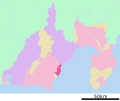 Yaizu in Shizuoka Prefecture Ja.svg 640 × 536; 11 KB
-
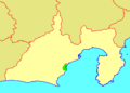
 Yaizu in Shizuoka Prefecture.png 1,281 × 801; 43 KB
-
 Yaizu Koishi River 2020-04 ac.jpg 5,863 × 3,899; 3.31 MB
-
 Yaizu Port 2009-05-03.jpg 3,000 × 2,000; 1.74 MB
-
 Yaizu Zenmon Green Road 2020-04 ac.jpg 5,863 × 3,899; 3.46 MB
-
 Yaizu.jpg 4,800 × 2,560; 4.51 MB
-
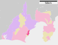
 YaizuShiKennai map.png 320 × 230; 9 KB
-
 Young of sardines rice,Yaizu-city,Japan.JPG 3,872 × 2,592; 4.92 MB
-
 地図-静岡県大井川町-2006.png 320 × 230; 4 KB
-
 地図-静岡県焼津市-2006.png 320 × 230; 4 KB
-
 地蔵 - panoramio (2).jpg 1,888 × 1,260; 1.11 MB
-
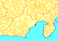
 基礎自治体位置図 22212.svg 571 × 446; 11 KB
-
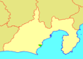
 基礎自治体位置図 22402.svg 640 × 536; 11 KB
-
 山道 - panoramio.jpg 1,888 × 1,260; 1.1 MB
-
 山道と祠 - panoramio.jpg 1,260 × 1,888; 1.17 MB
-
 河口野鳥園展望台 - panoramio.jpg 3,776 × 2,520; 3.22 MB
-
 焼津市遠景 - panoramio.jpg 2,816 × 2,112; 1.35 MB
-
 花沢の里 山村集落の風景.jpg 1,181 × 787; 413 KB
-
 静岡県焼津市上小杉 - panoramio.jpg 3,072 × 2,048; 2.09 MB
-
 静岡県焼津市柳新屋付近(新幹線から撮影) - panoramio.jpg 2,048 × 1,536; 703 KB


.jpg)
.jpg)


.jpg)


