Category:Glacier Point
Jump to navigation
Jump to search
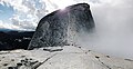
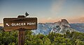
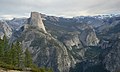
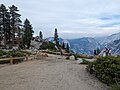
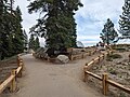
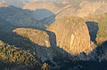
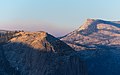
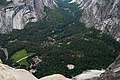
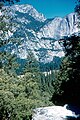
English: Glacier Point is a granite rock formation and scenic viewpoint above Yosemite Valley, in Yosemite National Park, California. The promontory is located on the south wall of the valley, at an elevation of 7,214 feet (2,199 m), and is 3,200 feet (980 m)above Curry Village at its base on the valley floor. Access is by Glacier Point Road, or the Four Mile Trail.
viewpoint above Yosemite Valley, in California, USA  .jpg) | |||||
| Upload media | |||||
| Instance of | |||||
|---|---|---|---|---|---|
| Part of | |||||
| Located in protected area | |||||
| Location | Mariposa County, California, Pacific States Region | ||||
| Mountain range | |||||
| Climbing route | |||||
| Elevation above sea level |
| ||||
 | |||||
Subcategories
This category has the following 3 subcategories, out of 3 total.
G
V
Media in category "Glacier Point"
The following 68 files are in this category, out of 68 total.
-
 Blue Skies at Yosemite (Unsplash).jpg 4,096 × 2,102; 2.67 MB
-
 Brave person walking out on the glacier point ledge.jpg 1,280 × 960; 242 KB
-
 Calling (Unsplash).jpg 3,456 × 5,184; 1.27 MB
-
 Firemen at Glacier Point - July 12 1969.jpg 378 × 258; 125 KB
-
 Girl Posing at Glacier Point Yosemite 2013.jpg 4,438 × 2,611; 4.98 MB
-
 Glacier Point (8592981160).jpg 6,790 × 2,519; 5.33 MB
-
 Glacier Point (Unsplash oSMYeEq6YPo).jpg 4,668 × 3,112; 5.5 MB
-
 Glacier Point (Unsplash).jpg 3,768 × 2,056; 5.36 MB
-
 Glacier Point - panoramio (2).jpg 2,048 × 1,536; 621 KB
-
 Glacier Point - panoramio.jpg 1,536 × 2,048; 618 KB
-
 Glacier Point golden hour (Unsplash).jpg 5,760 × 3,840; 2.3 MB
-
 Glacier Point Hotel - Fire Escape Ladders.jpg 3,974 × 3,027; 9.53 MB
-
 Glacier Point Hotel from the air.jpg 3,980 × 3,015; 7.78 MB
-
 Glacier Point Hotel Gutleben Album.jpg 4,155 × 2,886; 8.02 MB
-
 Glacier Point Hotel Lobby.jpg 4,197 × 2,850; 6.43 MB
-
 Glacier Point Hotel showing snow level at the second story.tif 3,850 × 2,233; 24.62 MB
-
 Glacier Point Hotel Site.jpg 4,183 × 2,853; 8.73 MB
-
 Glacier Point Locomobile.jpg 2,287 × 5,244; 4.81 MB
-
 Glacier Point Lookout, Yosemite National Park, CA.jpg 2,496 × 1,664; 1.45 MB
-
 Glacier Point Parque Nacional Yosemite3685.JPG 2,560 × 1,532; 2.57 MB
-
 Glacier Point path and building Yosemite CA 2023-07-16 18-55-06 1.jpg 4,080 × 3,072; 4.45 MB
-
 Glacier Point path and valley Yosemite CA 2023-07-16 18-55-03 1.jpg 4,080 × 3,072; 4.17 MB
-
 Glacier Point two paths diverge Yosemite CA 2023-07-16 18-43-17 1.jpg 4,080 × 3,072; 5.28 MB
-
 Glacier Point Yosemite August 2013 001.jpg 4,928 × 3,264; 5 MB
-
 Glacier Point Yosemite August 2013 003.jpg 4,928 × 3,264; 6.83 MB
-
 Glacier Point Yosemite August 2013 004.jpg 4,928 × 3,264; 6.27 MB
-
 Glacier Point Yosemite August 2013 006.jpg 4,928 × 3,080; 4.67 MB
-
 Glacier Point Yosemite National Park (3353796395).jpg 3,264 × 2,448; 5.81 MB
-

-
 Glacier Point, United States (Unsplash HrUwIKrmPm0).jpg 6,000 × 4,000; 1.59 MB
-
 Glacier Point, United States (Unsplash ke2-WbTxINI).jpg 6,000 × 4,000; 1.3 MB
-
 Glacier Point, United States (Unsplash LMXI9cjVYXk).jpg 6,000 × 4,000; 1.38 MB
-
 Glacier Point, Yosemite Valley, United States (Unsplash 71Ql9l7dyrQ).jpg 4,608 × 2,304; 5.36 MB
-
 Glacier Point, Yosemite Valley, United States (Unsplash Qf3E-YAuc w).jpg 5,760 × 3,840; 1.26 MB
-
 Glacier Point, Yosemite Valley, United States (Unsplash V9ehOMxti60).jpg 6,000 × 4,000; 3.78 MB
-
 Glacier-Point-Hotel-Snowshoe.jpg 3,963 × 2,756; 6.34 MB
-
 Glacier-Point-Hotel-Veranda.jpg 3,920 × 2,746; 5.08 MB
-
 Glacierpinetree.jpg 596 × 895; 180 KB
-
 Glacierpinetree2.jpg 596 × 897; 142 KB
-
 GlacierPoint-by-ClaudineFrère-1740-72dpi.jpg 640 × 426; 85 KB
-
 Half Dome - Glacier Point, Yosemite National Park, California, USA - August 1995.jpg 2,143 × 3,215; 9.08 MB
-
 Half Dome - panoramio (4).jpg 1,936 × 2,592; 2.12 MB
-
 Half Dome Yosemite 507-0733.jpg 2,304 × 1,728; 628 KB
-
 Isolation (Unsplash).jpg 6,000 × 3,533; 9.81 MB
-
 Managing Fire in Yosemity NP.jpg 2,568 × 1,926; 1.34 MB
-
 Master Plan for Yosemite National Park - Glacier Point.jpg 10,952 × 7,748; 77.24 MB
-

-
 Near Glacier point, Yosemite (26068897238).jpg 5,160 × 3,940; 3.93 MB
-
 On top of the world (Unsplash JMdgknOnV4c).jpg 3,306 × 1,796; 2.65 MB
-
 Panoram of Glacier Point and Half Dome.jpg 7,042 × 1,345; 5.93 MB
-
 Panorama Trail Trailhead.jpg 4,608 × 3,456; 5.24 MB
-
 Peaceful landscape in Yosemite (Unsplash).jpg 4,710 × 3,264; 2.42 MB
-
 Pohled z Glacier Point - Yosemite Village - panoramio.jpg 3,872 × 2,592; 4.26 MB
-
 Scenery of Yosemite.JPG 3,264 × 2,448; 4.26 MB
-
 Some Places Make You Feel Really Small (Unsplash).jpg 5,472 × 3,648; 14.92 MB
-
 CA ground squirrel eating, Glacier Point.jpg 2,448 × 3,264; 2.58 MB
-
 Sunset from Glacier Point - panoramio.jpg 2,048 × 1,536; 629 KB
-
-
 Twilight at Glacier Point - panoramio.jpg 2,048 × 1,536; 561 KB
-
 Glacier Point Parque Nacional Yosemite3680.JPG 2,560 × 1,920; 2.72 MB
-
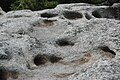 Weathering pits - granitic rock - Glacier Point, Yosemite National Park, California.jpg 3,008 × 2,000; 2.92 MB
-
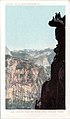
 Yosemite - Climbing to Glacier Point - 4096400928.jpg 536 × 780; 260 KB
-
 Yosemite - Climbing to Glacier Point.jpg 500 × 750; 294 KB
-
 Yosemite - Further Out - panoramio.jpg 1,280 × 1,024; 345 KB
-
 Yosemite 01.jpg 3,150 × 1,258; 396 KB
-
 Yosemite National Park - Glacier Point.jpg 1,000 × 674; 349 KB
-
 Yosemite Park, Glacier Point, Wikiekspedycja 2012 USA crew.jpg 4,471 × 2,971; 5.51 MB
-
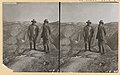
 Yosemite Valley CA - Glacier Point and South Dome (NBY 431996).jpg 486 × 827; 60 KB
.jpg)

.jpg)


.jpg)
.jpg)

.jpg)


.jpg)

.jpg)
.jpg)
.jpg)
.jpg)
.jpg)
.jpg)


.jpg)

.jpg)


_-_(28141020944).jpg)
.jpg)
.jpg)

.jpg)


.jpg)


.jpg)
.jpg)