Category:Hexham
Jump to navigation
Jump to search

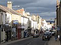
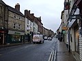
market town and civil parish in Northumberland, England  Beaumont Street in Hexham with the Courant Offices | |||||
| Upload media | |||||
| Instance of | |||||
|---|---|---|---|---|---|
| Location | Northumberland, North East England, England | ||||
| Population |
| ||||
| Area |
| ||||
| Different from | |||||
| Said to be the same as | Hexham (Wikimedia duplicated page, civil parish) | ||||
 | |||||
Deutsch: Hexham ist eine Stadt in Northumberland, England, am Fluss Tyne, Verwaltungssitz des Distrikts Tynedale. Sie hat 11.139 Einwohner (Stand: 2001).
English: Hexham is a market town in Northumberland, England, located south of the River Tyne, and was the administrative centre for the Tynedale district in Northumberland from 1974–2009. Hexham is one of three major towns in Tynedale along with Prudhoe and Haltwhistle, although in terms of population, Prudhoe is Tynedale's largest town. In 2001 Hexham had a population of 11,139.
Français : Hexham est une ville située dans le Northumberland en Angleterre. Elle a été jumelée avec Saint-Lunaire dans l'Ille-et-Vilaine en Bretagne et est jumelée depuis 1992 avec Noyon dans l'Oise en Picardie (France) ainsi qu'avec Metzingen en Allemagne avec laquelle Noyon est également jumelée. Ce jumelage triangulaire est un des rares existants en Europe et ilpermet aux Anglais, Français et Allemands d'avoir des amis communs dans les trois villes.
Italiano: Hexham è una cittadina inglese di circa 11.000 abitanti nel Northumberland: sorge sul fiume Tyne, a ovest di Newcastle.
Latina: Incolae noti:
Nederlands: Hexham is een plaats en civil parish in het Engelse graafschap Northumberland. De plaats telde in 2001, 11.139 inwoners en is het bestuurlijk centrum van Tynedale.
Română: Hexham este un oraş în comitatul Northumberland, regiunea North West, Anglia. Oraşul se află în districtul Tynedale a cărui reşedinţă este.
Subcategories
This category has the following 16 subcategories, out of 16 total.
B
- Barrasford Quarry (15 F)
C
H
- Hamburn Hall farm (5 F)
- Hexham Racecourse (15 F)
- Hexham War Memorial (14 F)
P
- Plaques in Hexham (26 F)
S
- Streets in Hexham (3 F)
T
W
- West Dipton Burn (8 F)
- Wydon Burn (9 F)
- Wydon Water (17 F)
Media in category "Hexham"
The following 200 files are in this category, out of 1,599 total.
(previous page) (next page)-
 "Country Tails" - geograph.org.uk - 6186885.jpg 640 × 480; 105 KB
-
 "Festive" golf - geograph.org.uk - 5230304.jpg 640 × 480; 258 KB
-
 "Garden Friends" at Hexham Hospital - geograph.org.uk - 6211593.jpg 640 × 480; 109 KB
-
 "Hexham Gate" - geograph.org.uk - 4865561.jpg 640 × 480; 325 KB
-
 "Hexham in Bloom" at Hexham Hospital - geograph.org.uk - 6211584.jpg 640 × 480; 175 KB
-
 "Hexham in Bloom" at Hexham Hospital - geograph.org.uk - 6211589.jpg 640 × 480; 177 KB
-
 "No sat navs" - geograph.org.uk - 2250940.jpg 640 × 480; 143 KB
-

-
 (Part of) Cattle Market, NE46 - geograph.org.uk - 4394292.jpg 640 × 480; 78 KB
-
 (Part of) Market Street, NE46 - geograph.org.uk - 4396345.jpg 480 × 640; 59 KB
-
 (Part of) the Market Place (2) - geograph.org.uk - 5773677.jpg 640 × 480; 113 KB
-
 (Part of) the Market Place - geograph.org.uk - 5773673.jpg 480 × 640; 101 KB
-
 (Part of) Tyne Green - geograph.org.uk - 1081032.jpg 640 × 480; 133 KB
-
 (Part of) Tyne Green and the River Tyne - geograph.org.uk - 1072285.jpg 640 × 480; 163 KB
-

-
 ....and if the coast is clear... - geograph.org.uk - 4894800.jpg 640 × 630; 302 KB
-
 12, Hencotes.jpg 6,000 × 8,000; 9.97 MB
-
 13 - geograph.org.uk - 4394298.jpg 480 × 640; 53 KB
-
 13 Hallgate Hexham - geograph.org.uk - 4081218.jpg 731 × 1,024; 315 KB
-
 18th C gravestone, Hexham Abbey - geograph.org.uk - 2819436.jpg 480 × 640; 110 KB
-
 2015 - Hadrian's Wall Trip (17549885540).jpg 3,648 × 2,736; 3.37 MB
-
 3, Market Street 2022.jpg 8,000 × 6,000; 9.21 MB
-
 6 And 8, Hencotes.jpg 6,000 × 8,000; 6.44 MB
-
 60103 at Hexham - August 2016 (1) - geograph.org.uk - 5075563.jpg 1,250 × 1,049; 1.57 MB
-
 60103 at Hexham - August 2016 (2) - geograph.org.uk - 5075569.jpg 1,250 × 1,085; 1.37 MB
-
 66595 entering Hexham - August 2016 - geograph.org.uk - 5075577.jpg 1,250 × 998; 1.36 MB
-
 7 ^ 8 Beaumont Street, Hexham - geograph.org.uk - 5463215.jpg 640 × 427; 291 KB
-
 9, Market Street.jpg 6,000 × 8,000; 10.33 MB
-
 A chilly day on the river - geograph.org.uk - 4277496.jpg 640 × 480; 315 KB
-
 A chilly morning on the Tyne at Hexham - geograph.org.uk - 5280285.jpg 640 × 479; 317 KB
-

-
 A murder of crows - geograph.org.uk - 4645152.jpg 640 × 480; 475 KB
-
 A prospect of Hexham - geograph.org.uk - 4782103.jpg 640 × 480; 311 KB
-
 A prospect of Hexham - geograph.org.uk - 6186942.jpg 640 × 480; 134 KB
-
 A prospect of Hexham - geograph.org.uk - 6186948.jpg 640 × 480; 128 KB
-
 A sparrowhawk calls - geograph.org.uk - 3848739.jpg 640 × 480; 69 KB
-
 A sparrowhawk calls - geograph.org.uk - 4894791.jpg 428 × 640; 206 KB
-
 A speckled wood in a speckled wood - geograph.org.uk - 5793316.jpg 640 × 480; 129 KB
-
 A touch of Mongolia comes to Tynedale - geograph.org.uk - 6186933.jpg 640 × 480; 127 KB
-
 A touch of Mongolia comes to Tynedale - geograph.org.uk - 6186935.jpg 640 × 480; 142 KB
-
 A trap for the unwary - geograph.org.uk - 5280278.jpg 640 × 480; 304 KB
-
 A tributary of Cockshaw Burn (2) - geograph.org.uk - 3776101.jpg 640 × 480; 162 KB
-
 A tributary of Cockshaw Burn (2) - geograph.org.uk - 3782517.jpg 480 × 640; 151 KB
-
 A tributary of Cockshaw Burn - geograph.org.uk - 3776097.jpg 640 × 480; 131 KB
-
 A tributary of Cockshaw Burn - geograph.org.uk - 3780749.jpg 480 × 640; 155 KB
-
 A tributary of Cockshaw Burn - geograph.org.uk - 3782514.jpg 480 × 640; 145 KB
-

-
 A yellow bike in Hexham - geograph.org.uk - 4645681.jpg 480 × 640; 464 KB
-
 A69 westbound near Coastley Dene - geograph.org.uk - 4745175.jpg 640 × 480; 47 KB
-
 A695 at Hexham town boundary - geograph.org.uk - 4745076.jpg 640 × 480; 48 KB
-
 A695 at Hillside Road, Hexham - geograph.org.uk - 4745429.jpg 640 × 481; 47 KB
-
 Abbey Close - geograph.org.uk - 5773657.jpg 640 × 480; 140 KB
-
 Abbey Gardens, Hexham - geograph.org.uk - 3193982.jpg 640 × 480; 608 KB
-
 Access ramp to the A69 - geograph.org.uk - 3837554.jpg 640 × 480; 100 KB
-
 Access road to Hexham fish pass - geograph.org.uk - 5071188.jpg 640 × 480; 363 KB
-

-
 All the fun of the Fair - geograph.org.uk - 1808598.jpg 640 × 480; 95 KB
-
 Alley behind St Wilfrid's Road, Hexham - geograph.org.uk - 5289634.jpg 640 × 480; 267 KB
-
 Alleyway east of Elvaston Road (2) - geograph.org.uk - 843389.jpg 480 × 640; 143 KB
-
 Alleyway east of Elvaston Road (3) - geograph.org.uk - 843432.jpg 480 × 640; 128 KB
-
 Alleyway east of Elvaston Road (4) - geograph.org.uk - 843437.jpg 480 × 640; 139 KB
-
 Alleyway east of Elvaston Road (5) - geograph.org.uk - 843443.jpg 480 × 640; 143 KB
-
 Alleyway east of Elvaston Road (6) - geograph.org.uk - 843447.jpg 480 × 640; 143 KB
-
 Alleyway east of Elvaston Road (7) - geograph.org.uk - 843480.jpg 480 × 640; 139 KB
-
 Alleyway east of Elvaston Road (8) - geograph.org.uk - 843487.jpg 480 × 640; 132 KB
-
 Alleyway east of Elvaston Road (9) - geograph.org.uk - 843491.jpg 480 × 640; 114 KB
-
 Alleyway east of Elvaston Road - geograph.org.uk - 843385.jpg 480 × 640; 121 KB
-
 Alleyway off Eastgate - geograph.org.uk - 843365.jpg 480 × 640; 111 KB
-
 Allotments, Dipton Mill Road - geograph.org.uk - 2902604.jpg 640 × 480; 129 KB
-
 Allotments, Dipton Mill Road - geograph.org.uk - 2910704.jpg 640 × 480; 136 KB
-
 Allotments, Dipton Mill Road - geograph.org.uk - 2910705.jpg 640 × 480; 121 KB
-
 Amazing autumn leaves in the Hexham Abbey Garden - panoramio.jpg 800 × 535; 386 KB
-

-

-
 Amazing autumn trees in the Hexham Abbey Garden - panoramio.jpg 800 × 535; 289 KB
-
 Amazing beautiful View nea - panoramio.jpg 800 × 500; 168 KB
-
 An anxious moment - geograph.org.uk - 5280288.jpg 640 × 480; 290 KB
-
 Approaching the 19th - geograph.org.uk - 1073182.jpg 640 × 480; 115 KB
-
-
 Archaeology At Vindolanda (7617593782) (cropped).jpg 853 × 953; 883 KB
-
 Archaeology At Vindolanda (7617593782).jpg 3,094 × 1,913; 5.47 MB
-
 Arches on Cowgarth, Hexham - geograph.org.uk - 6420600.jpg 1,024 × 768; 202 KB
-
 Archway To Church Flags Archway To Cowgarth.jpg 6,000 × 8,000; 11.43 MB
-
 Archway To North West Of The Old Grammar School.jpg 6,000 × 8,000; 14.67 MB
-
 Armed Forces Day, 2012, Hexham - geograph.org.uk - 3037039.jpg 640 × 480; 129 KB
-
 Armed Forces Day, 2012, Hexham - geograph.org.uk - 3037040.jpg 640 × 480; 98 KB
-
 Armed Forces Day, 2012, Hexham - geograph.org.uk - 3037041.jpg 640 × 480; 106 KB
-
 Armed Forces Day, 2012, Hexham - geograph.org.uk - 3037043.jpg 640 × 480; 126 KB
-
 Armed Forces Day, 2012, Hexham - geograph.org.uk - 3037046.jpg 640 × 480; 128 KB
-
 Armed Forces Day, 2012, Hexham - geograph.org.uk - 3037051.jpg 640 × 480; 110 KB
-
 Armed Forces Day, 2012, Hexham - geograph.org.uk - 3037076.jpg 480 × 640; 104 KB
-
 Army Reserve Centre, Hexham - geograph.org.uk - 3996844.jpg 640 × 480; 129 KB
-
 Army Reserve Centre, Hexham - geograph.org.uk - 3996846.jpg 640 × 480; 111 KB
-

-
 Artificial cascade on Wydon Burn - geograph.org.uk - 6185490.jpg 480 × 640; 179 KB
-

-
 Ascending Causey Hill Road - geograph.org.uk - 4891334.jpg 640 × 480; 65 KB
-
 Assorted long-distance trails - geograph.org.uk - 6188058.jpg 480 × 640; 183 KB
-
 At Beacon Hill Farm - geograph.org.uk - 6180666.jpg 640 × 480; 118 KB
-
 ATS, Haugh Lane, Hexham - geograph.org.uk - 6421413.jpg 1,024 × 768; 193 KB
-
-

-

-
 Autumn View in the Avenue of Tyne Green - panoramio - somaliayaswan.jpg 800 × 535; 328 KB
-
 Autumn View in the Avenue of Tyne Green - panoramio.jpg 800 × 535; 315 KB
-
 Avenue of trees at Tynedale Country Park - geograph.org.uk - 1073186.jpg 640 × 480; 161 KB
-

-

-
-
 Avenue of trees on Tyne Green (2) - geograph.org.uk - 1072343.jpg 640 × 480; 146 KB
-
 Avenue of trees on Tyne Green - geograph.org.uk - 1072301.jpg 640 × 480; 163 KB
-
 Avenue of trees on Tyne Green - geograph.org.uk - 6057377.jpg 480 × 640; 414 KB
-
 Avenue of trees on Tyne Green - geograph.org.uk - 6057427.jpg 640 × 480; 422 KB
-
 B6305 bears right ahead - geograph.org.uk - 3652288.jpg 3,648 × 2,736; 2.1 MB
-
 B6306 towards Blanchland - geograph.org.uk - 4892014.jpg 640 × 480; 87 KB
-
 B6531 at St Andrews Cemetery - geograph.org.uk - 4745161.jpg 640 × 480; 39 KB
-
 B6531 at Tynegreen - geograph.org.uk - 4745154.jpg 640 × 480; 56 KB
-
 B6531 nears the A69 junction - geograph.org.uk - 4745165.jpg 640 × 481; 29 KB
-
 Back alley - geograph.org.uk - 4887598.jpg 480 × 640; 253 KB
-
 Back of Loughbrow Park - geograph.org.uk - 2919458.jpg 640 × 480; 83 KB
-
 Back of Loughbrow Park - geograph.org.uk - 6432466.jpg 640 × 480; 96 KB
-
 Back path of the Abbey - panoramio.jpg 800 × 535; 226 KB
-
 Back Row - geograph.org.uk - 674648.jpg 480 × 640; 69 KB
-
 Back way out of Beale's Department Store - geograph.org.uk - 5286385.jpg 480 × 640; 275 KB
-
 Bales of straw in the evening sun - geograph.org.uk - 2008263.jpg 640 × 480; 91 KB
-
 Band in the Sele - geograph.org.uk - 2924025.jpg 640 × 360; 107 KB
-
 Band stand in a Hexham Park - geograph.org.uk - 4206448.jpg 1,500 × 1,061; 2.25 MB
-
 Bandstand in Hexham Abbey Gardens - geograph.org.uk - 3194793.jpg 640 × 480; 549 KB
-

-
 Bandstand in the Seal, Hexham, Northumberland - geograph.org.uk - 3463175.jpg 1,024 × 768; 255 KB
-
 Bandstand in the Seal, Hexham, Northumberland - geograph.org.uk - 3463188.jpg 1,024 × 768; 254 KB
-
 Bandstand in the Sele (2) - geograph.org.uk - 4988278.jpg 640 × 480; 142 KB
-
 Bandstand in the Sele - geograph.org.uk - 4988273.jpg 640 × 480; 111 KB
-
 Bandstand in the Sele - geograph.org.uk - 5773650.jpg 640 × 480; 146 KB
-
 Bandstand in the snow - geograph.org.uk - 2226318.jpg 640 × 480; 117 KB
-
 Bandstand Restoration, Hexham - geograph.org.uk - 4936545.jpg 2,048 × 1,536; 1.48 MB
-
 Bandstand, Abbey Grounds, Hexham - geograph.org.uk - 5722694.jpg 1,024 × 768; 312 KB
-
 Bandstand, Hexham - geograph.org.uk - 187024.jpg 640 × 479; 63 KB
-
 Bandstand, Sele Park, Hexham - geograph.org.uk - 5875792.jpg 1,024 × 768; 244 KB
-

-
 Bankfull River Tyne - geograph.org.uk - 6057426.jpg 640 × 480; 327 KB
-
 Basket weaving in the Sele - geograph.org.uk - 2924030.jpg 480 × 640; 98 KB
-
 Battle Hill (2) - geograph.org.uk - 1710650.jpg 640 × 480; 72 KB
-
 Battle Hill Hexham - geograph.org.uk - 5289640.jpg 480 × 640; 246 KB
-
 Battle Hill in Hexham - geograph.org.uk - 3194581.jpg 4,608 × 3,456; 4.53 MB
-
 Battle Hill, Hexham - geograph.org.uk - 3195065.jpg 1,600 × 1,200; 309 KB
-
 Battle Hill, Hexham - geograph.org.uk - 3215527.jpg 640 × 480; 74 KB
-
 Beacon Hill Farm - geograph.org.uk - 6180663.jpg 640 × 480; 144 KB
-
 Beales, Fore Street - geograph.org.uk - 2819464.jpg 640 × 480; 74 KB
-
 Beales, Priestpopple - geograph.org.uk - 2819467.jpg 640 × 480; 70 KB
-
 Beaumont Street - geograph.org.uk - 3727707.jpg 640 × 480; 89 KB
-
 Beaumont Street, Hexham - geograph.org.uk - 4936537.jpg 2,048 × 1,536; 1.14 MB
-
 Beaumont Street, Hexham - geograph.org.uk - 5712912.jpg 1,024 × 770; 164 KB
-
 Beaumont Street, NE46 - geograph.org.uk - 4988291.jpg 640 × 480; 95 KB
-
 Beck, Hackwood Park, Hexham - geograph.org.uk - 1627783.jpg 640 × 480; 142 KB
-
 Beech Avenue - geograph.org.uk - 631291.jpg 640 × 440; 92 KB
-

-
 Bench mark on West Road - geograph.org.uk - 1994330.jpg 480 × 640; 101 KB
-
 Best view of the Egger works - geograph.org.uk - 4782104.jpg 640 × 480; 309 KB
-
 Big bird - geograph.org.uk - 6427786.jpg 480 × 640; 138 KB
-
-

-
 Bike ^ Go - Hexham station - September 2018 - geograph.org.uk - 5915256.jpg 6,324 × 4,551; 4.57 MB
-
 Birkey Burn - geograph.org.uk - 1308733.jpg 640 × 480; 160 KB
-
 Black Hall Hexhamshire - geograph.org.uk - 242886.jpg 640 × 480; 120 KB
-
 Black House - geograph.org.uk - 6005913.jpg 5,184 × 3,888; 390 KB
-
 Black House - geograph.org.uk - 6005916.jpg 5,184 × 3,888; 411 KB
-
 Black-headed Gulls beside the Tyne - geograph.org.uk - 6046113.jpg 640 × 480; 294 KB
-
 Black-headed gulls beside the Tyne - geograph.org.uk - 6046120.jpg 640 × 480; 217 KB
-
 Black-headed Gulls beside the Tyne - geograph.org.uk - 6046127.jpg 640 × 480; 316 KB
-
 Blackhill Farm - geograph.org.uk - 6005857.jpg 5,184 × 3,888; 617 KB
-
 Blossom Hill (2) - geograph.org.uk - 1814156.jpg 640 × 480; 59 KB
-
 Blossom Hill (3) - geograph.org.uk - 1884201.jpg 640 × 480; 76 KB
-
 Blossom Hill Farm - geograph.org.uk - 4645651.jpg 640 × 480; 412 KB
-
 Boardwalk to Causey Hill Road - geograph.org.uk - 1704782.jpg 640 × 480; 144 KB
-
 Bondgate Close - geograph.org.uk - 2921392.jpg 640 × 480; 83 KB
-
 Bottom of Eastgate, Hexham - geograph.org.uk - 1992718.jpg 480 × 640; 80 KB
-
 Bottom of Eastgate, Hexham - geograph.org.uk - 1992719.jpg 480 × 640; 76 KB
-
 Bouchon Bistrot - geograph.org.uk - 6332554.jpg 1,600 × 1,157; 281 KB
-
 Bowling green in Hexham Park - geograph.org.uk - 5414743.jpg 5,449 × 3,781; 4.19 MB
-
 Bowling green pavilion, Hexham - geograph.org.uk - 1495208.jpg 640 × 480; 72 KB
-
 Bowling in beautiful surroundings - geograph.org.uk - 3027278.jpg 3,648 × 2,736; 2.24 MB
-
 Bowling is off for the day^ - geograph.org.uk - 2226324.jpg 640 × 480; 63 KB
-
 Box junction, Hexham - geograph.org.uk - 1992715.jpg 640 × 480; 85 KB
-
 Box junction, Hexham - geograph.org.uk - 1992716.jpg 640 × 480; 84 KB
-
 Brick shelter on Tyne Green - geograph.org.uk - 6057424.jpg 640 × 480; 354 KB
-
 Bridge arch, Alemouth Road, Hexham - geograph.org.uk - 6420369.jpg 1,024 × 768; 161 KB
-

-
 Bridleway between Blackhill Farm and Hexham Racecourse - geograph.org.uk - 4959504.jpg 3,984 × 2,988; 6.01 MB
-
 Bridleway between Coastley and Low Gate - geograph.org.uk - 1594963.jpg 640 × 480; 147 KB
-
 Bridleway east of Hackford Farm (2) - geograph.org.uk - 1596094.jpg 640 × 480; 139 KB
-
 Bridleway east of Hackford Farm (3) - geograph.org.uk - 1596095.jpg 480 × 640; 131 KB
-
 Bridleway east of Hackford Farm - geograph.org.uk - 1594358.jpg 640 × 480; 118 KB
-
 Bridleway from Dotland to Yarridge Lane - geograph.org.uk - 3301222.jpg 640 × 480; 121 KB
-

-

-
 Bridleway meets Blackhill Farm track - geograph.org.uk - 4959490.jpg 3,984 × 2,988; 5.62 MB
-
 Bridleway meets Dipton wood - geograph.org.uk - 4959545.jpg 3,984 × 2,988; 6.72 MB
-
 Bridleway near Low Gate - geograph.org.uk - 296975.jpg 480 × 640; 138 KB
-
 Bridleway on the west side of High Wood - geograph.org.uk - 1594274.jpg 640 × 480; 111 KB


_Cattle_Market,_NE46_-_geograph.org.uk_-_4394292.jpg)
_Market_Street,_NE46_-_geograph.org.uk_-_4396345.jpg)
_the_Market_Place_(2)_-_geograph.org.uk_-_5773677.jpg)
_the_Market_Place_-_geograph.org.uk_-_5773673.jpg)
_Tyne_Green_-_geograph.org.uk_-_1081032.jpg)
_Tyne_Green_and_the_River_Tyne_-_geograph.org.uk_-_1072285.jpg)
_the_Old_Priory,_Hexham_Abbey_(2)_-_geograph.org.uk_-_4392724.jpg)


.jpg)


_-_geograph.org.uk_-_5075563.jpg)
_-_geograph.org.uk_-_5075569.jpg)


_-_geograph.org.uk_-_3776101.jpg)
_-_geograph.org.uk_-_3782517.jpg)


_-_geograph.org.uk_-_843389.jpg)
_-_geograph.org.uk_-_843432.jpg)
_-_geograph.org.uk_-_843437.jpg)
_-_geograph.org.uk_-_843443.jpg)
_-_geograph.org.uk_-_843447.jpg)
_-_geograph.org.uk_-_843480.jpg)
_-_geograph.org.uk_-_843487.jpg)
_-_geograph.org.uk_-_843491.jpg)


.jpg)


_(cropped).jpg)
.jpg)


.jpg)


_-_geograph.org.uk_-_1073550.jpg)

_-_geograph.org.uk_-_1072343.jpg)


_-_geograph.org.uk_-_4988278.jpg)


_-_geograph.org.uk_-_1710650.jpg)


_-_geograph.org.uk_-_1814156.jpg)
_-_geograph.org.uk_-_1884201.jpg)


_-_geograph.org.uk_-_1596094.jpg)
_-_geograph.org.uk_-_1596095.jpg)


