Category:Highland Main Line
Zur Navigation springen
Zur Suche springen
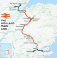
English: The Highland Main Line is in Scotland, linking Inverness with Perth and Stirling.
meist eingleisige, nicht elektrifizierte Bahnlinie in Schottland   | |||||
| Medium hochladen | |||||
| Ist ein(e) | |||||
|---|---|---|---|---|---|
| Ist Teil von |
| ||||
| Ort | Perth and Kinross, Schottland | ||||
| Physisch verbunden mit | |||||
| Eigentümer/Besitzer | |||||
| Betreiber | |||||
| Besteht aus |
| ||||
| Länge |
| ||||
| Endpunkt (Objekt) | |||||
| |||||
Unterkategorien
Es werden 30 von insgesamt 30 Unterkategorien in dieser Kategorie angezeigt:
In Klammern die Anzahl der enthaltenen Kategorien (K), Seiten (S), Dateien (D)
A
B
- Blair Atholl railway station (22 D)
- Bridge of Allan railway station (13 D)
C
- Culloden Viaduct (54 D)
D
- Dalnaspidal railway station (9 D)
- Dalwhinnie railway station (37 D)
- Dunblane railway station (28 D)
- Dunning railway station (1 D)
F
- Forteviot railway station (2 D)
G
- Gleneagles railway station (31 D)
I
K
- Killiecrankie Viaduct (11 D)
- Kingussie railway station (57 D)
L
- Larbert railway station (11 D)
M
- Moy Viaduct (19 D)
- Murthly railway station (2 D)
N
- Newtonmore railway station (31 D)
P
- Perth railway station, Scotland (98 D)
- Pitlochry railway station (65 D)
S
- Slochd Mhuic Railway Viaduct (17 D)
T
- Tilt Viaduct (4 D)
Medien in der Kategorie „Highland Main Line“
Folgende 81 Dateien sind in dieser Kategorie, von 81 insgesamt.
-
 Highland Main Line.png 4.276 × 4.377; 7,1 MB
-
 01roadandrail 20000900.jpg 1.179 × 588; 94 KB
-
 A small bridge - geograph.org.uk - 2350784.jpg 1.000 × 750; 200 KB
-
 A9 Railway Bridge East of Blackford - geograph.org.uk - 493434.jpg 640 × 464; 68 KB
-
 Allt Dubhaig - geograph.org.uk - 232310.jpg 640 × 480; 120 KB
-

-
 Blackford, Highland Line, Perth and Kinross. View west.jpg 4.397 × 2.741; 2,93 MB
-
 Bridges - geograph.org.uk - 224840.jpg 640 × 480; 186 KB
-

-
 Dalguise Station, Perthshire - geograph.org.uk - 59522.jpg 640 × 480; 38 KB
-
 Dalnaspidal - geograph.org.uk - 29124.jpg 456 × 285; 31 KB
-

-
 Level crossing at Dalwhinnie - geograph.org.uk - 114062.jpg 640 × 480; 104 KB
-
 Druimuachdar Pass railway sign - geograph.org.uk - 385960.jpg 640 × 480; 103 KB
-
 Drumochter March2007.jpg 1.500 × 793; 107 KB
-
 Drumochter Pass from Boar of Badenoch.jpg 2.304 × 1.728; 395 KB
-
 Dunblane - Allan Water Viaduct.JPG 1.366 × 820; 526 KB
-
 Highland Line at Dalnacardoch - geograph.org.uk - 3173917.jpg 640 × 427; 416 KB
-
 Highland Main Line - geograph.org.uk - 2118234.jpg 1.000 × 750; 258 KB
-
 Highland Main Line - geograph.org.uk - 3721619.jpg 1.439 × 957; 520 KB
-
 Highland Mainline near Etteridge - geograph.org.uk - 5371378.jpg 1.600 × 1.600; 587 KB
-
 Highland Railway - geograph.org.uk - 279283.jpg 640 × 480; 60 KB
-
 Highland Railway - geograph.org.uk - 531915.jpg 640 × 480; 84 KB
-
 Highland Railway - geograph.org.uk - 985573.jpg 640 × 359; 78 KB
-
 Highland Railway, Blair Atholl - geograph.org.uk - 1593355.jpg 640 × 480; 134 KB
-
 Highland Railway, Calvine - geograph.org.uk - 1062436.jpg 640 × 480; 84 KB
-
 Inverness railway 2020645.jpg 640 × 393; 119 KB
-
 Inverness to Perth Railway Line - geograph.org.uk - 330270.jpg 640 × 480; 107 KB
-
 Inverness to Perth railway line south - geograph.org.uk - 245591.jpg 640 × 480; 174 KB
-
 Killiecrankie Railway Viaduct - geograph.org.uk - 1239416.jpg 480 × 640; 122 KB
-
 Level Crossing at Dalwhinnie - geograph.org.uk - 2761318.jpg 640 × 480; 90 KB
-
 Level Crossing, Dalwhinnie - geograph.org.uk - 2672299.jpg 3.264 × 2.448; 3,54 MB
-
 Lines heading south - geograph.org.uk - 5779585.jpg 4.117 × 3.087; 2,06 MB
-
 Millburn Level Crossing (9627458973).jpg 3.264 × 2.448; 1,16 MB
-
 Moy Wind Farm - geograph.org.uk - 6299867.jpg 1.024 × 768; 196 KB
-
 Near the Slochd Summit - geograph.org.uk - 121251.jpg 640 × 480; 280 KB
-
 Off the rails - geograph.org.uk - 507189.jpg 640 × 427; 85 KB
-
 Pass of Drumochter - geograph.org.uk - 35823.jpg 640 × 430; 70 KB
-

-
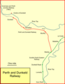 Perth and Dunkeld Rly.png 1.047 × 1.354; 68 KB
-
 Perth to Inverness railway - geograph.org.uk - 1364949.jpg 640 × 480; 121 KB
-
 Perth to Inverness railway line north - geograph.org.uk - 245594.jpg 640 × 480; 123 KB
-
 Pitlochry Ferry Road bridge.JPG 1.366 × 910; 735 KB
-
 Pitlochry Recreation Ground bridge.JPG 1.366 × 910; 749 KB
-
 Private level crossing near Lynchat - geograph.org.uk - 2170014.jpg 800 × 531; 166 KB
-
 Rail map Scotland Highland line.png 1.349 × 1.683; 385 KB
-
 Railway at Kincraig - geograph.org.uk - 560011.jpg 640 × 480; 55 KB
-
 Railway bridge - geograph.org.uk - 460059.jpg 640 × 424; 110 KB
-
 Railway bridge at Castletown - geograph.org.uk - 2646288.jpg 640 × 480; 113 KB
-
 Railway bridge at Kincraig - geograph.org.uk - 2462135.jpg 1.500 × 1.125; 322 KB
-
 Railway bridge near Loch Insh - geograph.org.uk - 1725613.jpg 640 × 427; 358 KB
-
 Railway bridge over the Earn - geograph.org.uk - 682876.jpg 640 × 480; 48 KB
-
 Railway bridge, Harbour Road - geograph.org.uk - 2706986.jpg 1.280 × 960; 1,01 MB
-
 Railway crossing - geograph.org.uk - 3239573.jpg 2.592 × 1.936; 2,4 MB
-
 Railway crossing near Newtonmore - geograph.org.uk - 1372951.jpg 497 × 640; 59 KB
-
 Railway Level Crossing - geograph.org.uk - 488689.jpg 640 × 458; 72 KB
-
 Railway line - geograph.org.uk - 564153.jpg 452 × 640; 87 KB
-
 Railway line - geograph.org.uk - 92161.jpg 640 × 480; 76 KB
-
 Railway Line and Whitemoss Golf Course - geograph.org.uk - 663002.jpg 640 × 425; 150 KB
-
 Railway line in Pitlochry - geograph.org.uk - 3206051.jpg 2.592 × 1.936; 2,37 MB
-
 Railway Line North to Aviemore - geograph.org.uk - 622862.jpg 640 × 427; 94 KB
-
 Railway Lines at Dalwhinnie - geograph.org.uk - 2644154.jpg 3.264 × 2.448; 3,54 MB
-
 Railway near layby 74 on the A9 - geograph.org.uk - 3686217.jpg 1.600 × 865; 344 KB
-
 Railway passing through the Pass of Killiecrankie - geograph.org.uk - 3599855.jpg 3.872 × 2.592; 7,03 MB
-
 Railway, River and Moorland - geograph.org.uk - 330262.jpg 640 × 480; 116 KB
-
 Road and rail - geograph.org.uk - 278761.jpg 640 × 480; 108 KB
-
 Semaphore signals at Dalwhinnie - geograph.org.uk - 4170898.jpg 1.024 × 768; 314 KB
-
 The A9 crosses the railway and River Garry - geograph.org.uk - 2141318.jpg 1.500 × 1.125; 872 KB
-
 The crossing at Dalwhinnie - geograph.org.uk - 4477345.jpg 640 × 480; 245 KB
-
 The Dalwhinnie railway crossing - geograph.org.uk - 4171113.jpg 1.024 × 768; 309 KB
-

-
 The new Dalnacardoch Signal Box - geograph.org.uk - 2033806.jpg 800 × 600; 81 KB
-
 The old A9 and Highland Railway - geograph.org.uk - 1089686.jpg 640 × 359; 71 KB
-
 The Railway Line at Dalguise - geograph.org.uk - 294033.jpg 640 × 480; 102 KB
-
 Tomatin Station (geograph 3511112).jpg 1.440 × 964; 625 KB
-
 Towards the sunset - geograph.org.uk - 3239656.jpg 2.592 × 1.936; 1,77 MB
-
 Train Heading North - geograph.org.uk - 300152.jpg 640 × 480; 116 KB
-
 Train in a landscape - geograph.org.uk - 3472043.jpg 3.264 × 2.448; 3,19 MB
-
 Train on Perth to Inverness line - geograph.org.uk - 2290456.jpg 1.500 × 1.125; 688 KB
-
 Under the Railway at Struan - geograph.org.uk - 3067975.jpg 1.200 × 803; 412 KB
-
 View from Raitts Cave - geograph.org.uk - 1725680.jpg 640 × 427; 307 KB


.jpg)


.jpg)


