Category:History of New Jersey
Jump to navigation
Jump to search
States of the United States: Alabama · Alaska · Arizona · Arkansas · California · Colorado · Connecticut · Delaware · Florida · Georgia · Hawaii · Idaho · Illinois · Indiana · Iowa · Kansas · Kentucky · Louisiana · Maine · Maryland · Massachusetts · Michigan · Minnesota · Mississippi · Missouri · Montana · Nebraska · Nevada · New Hampshire · New Jersey · New Mexico · New York · North Carolina · North Dakota · Ohio · Oklahoma · Oregon · Pennsylvania · Rhode Island · South Carolina · South Dakota · Tennessee · Texas · Utah · Vermont · Virginia · Washington · West Virginia · Wisconsin · Wyoming – Washington, D.C.
insular area of the United States: American Samoa · Guam · Northern Mariana Islands · Puerto Rico · United States Virgin Islands – Baker Island · Howland Island · Jarvis Island · Johnston Atoll · Midway Atoll · Navassa Island · Palmyra Atoll · Wake Island
insular area of the United States: American Samoa · Guam · Northern Mariana Islands · Puerto Rico · United States Virgin Islands – Baker Island · Howland Island · Jarvis Island · Johnston Atoll · Midway Atoll · Navassa Island · Palmyra Atoll · Wake Island
history of the US state of New Jersey | |||||
| Upload media | |||||
| Instance of |
| ||||
|---|---|---|---|---|---|
| Part of | |||||
| Facet of | |||||
| |||||
Subcategories
This category has the following 55 subcategories, out of 55 total.
*
A
- Sir Charles Asgill, 2nd Baronet (13 F)
B
C
D
E
F
- Former counties of New Jersey (empty)
G
- Garfield Tea House (4 F)
H
J
M
- Morro Castle (ship, 1930) (5 F)
N
O
P
- Pavonia, New Netherland (5 F)
S
U
- United States Radium Corporation (18 F)
W
Media in category "History of New Jersey"
The following 57 files are in this category, out of 57 total.
-

-
-
 1698PhilipLeaPANJmap.jpg 723 × 600; 282 KB
-
 1880 census Stevens Carpender.gif 2,560 × 3,076; 1.2 MB
-
 1910-era ethnic map of Newark, New Jersey.jpg 740 × 523; 262 KB
-
 1920 census Mills.gif 2,880 × 1,897; 1.05 MB
-
-
 Anthraxmailflow.jpg 1,085 × 800; 200 KB
-
 Appletons' Burr Aaron - Aaron Ramapo Pass house.jpg 712 × 469; 121 KB
-
 Arbuckle Bros. Coffee Co. (3092992805).jpg 798 × 478; 331 KB
-
 Augusta and Merlin on fire.png 644 × 440; 325 KB
-
 Authors and Writers Associated with Morristown.jpg 570 × 650; 108 KB
-
 BattleOfShortHills.jpg 4,860 × 4,094; 5.66 MB
-
 Burlington.nj.jpg 3,543 × 2,562; 388 KB
-

-
 Documents relating to the colonial history of the state of New Jersey, (1631-1776) (IA documentsrelatin04whit).pdf 808 × 1,297, 596 pages; 32.47 MB
-
 Documents relating to the colonial history of the state of New Jersey, (1631-1776) (IA documentsrelatin05whit).pdf 860 × 1,333, 546 pages; 31.25 MB
-
 Documents relating to the colonial history of the state of New Jersey, (1631-1776) (IA documentsrelatin09whit).pdf 991 × 1,658, 548 pages; 30.32 MB
-
 Documents relating to the colonial history of the state of New Jersey, (1631-1776) (IA documentsrelatin10whit).pdf 762 × 1,279, 548 pages; 29.54 MB
-
 Documents relating to the colonial history of the state of New Jersey, (1631-1776) (IA documentsrelatin14whit).pdf 816 × 1,258, 626 pages; 33.65 MB
-
 Documents relating to the colonial history of the state of New Jersey, (1631-1776) (IA documentsrelatin15whit).pdf 795 × 1,270, 620 pages; 33.35 MB
-
 Edgewater Vriessendael.JPG 416 × 616; 140 KB
-
 Electric railway journal (1911) (14736596256).jpg 3,600 × 2,480; 1.39 MB
-
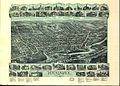
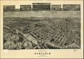 Garfield NJ 1909.jpg 1,132 × 806; 250 KB
-
 Guide to Naturalization Records in New Jersey, 1941.jpg 2,606 × 3,379; 3.42 MB
-
 Hackensack 1896.jpg 2,508 × 1,788; 1.32 MB
-
 Hall - Mills murder case in the New York Times on December 4, 1926.jpg 1,296 × 1,956; 664 KB
-
 Hall–Mills murder case in The New York Times on September 17, 1922.jpg 1,317 × 2,418; 1.25 MB
-
 Index of wills, inventories, etc. in the office of the secretary of state prior to 1901 .. (IA indexofwillsinve01newj).pdf 670 × 1,122, 448 pages; 28.43 MB
-
 Index of wills, inventories, etc. in the office of the secretary of state prior to 1901 .. (IA indexofwillsinve02newj).pdf 970 × 1,564, 524 pages; 32.58 MB
-
 RichardVarick.jpg 252 × 259; 5 KB
-
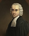
 John De Hart (cropped).jpeg 405 × 436; 49 KB
-
 John De Hart.jpeg 595 × 760; 64 KB
-
 JonathanDickinson (cropped).jpg 556 × 739; 37 KB
-
 Julia Nelson Colles.png 1,487 × 1,895; 4.01 MB
-
 Letter from Woodrow Wilson to Ruthven Deane about bookplates LCCN2007683283.jpg 5,003 × 6,016; 2.51 MB
-
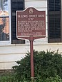 Lewis Condict House 01.jpg 1,536 × 2,048; 727 KB
-
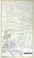
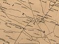 Mansfield Township 1859- panhandle.jpg 640 × 480; 57 KB
-
 Map of New Sweden.jpg 1,185 × 2,442; 1.63 MB
-
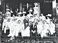 McAlpin Wedding Party 1905.jpg 5,555 × 4,135; 7.97 MB
-
 JonathanDickinson (3).jpg 1,318 × 1,600; 1.17 MB
-
 JonathanDickinson.jpg 1,647 × 2,000; 1.5 MB
-
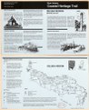
 New Jersey Coastal Heritage Trail, Absecon & Cape May regions LOC 96684343.jpg 4,306 × 5,215; 3.11 MB
-
 New Jersey Coastal Heritage Trail, Absecon & Cape May regions LOC 96684343.tif 4,306 × 5,215; 64.25 MB
-
 New Jersey Coastal Heritage Trail, Delsea region LOC 96687583.jpg 4,289 × 5,250; 3.46 MB
-
 New Jersey Coastal Heritage Trail, Delsea region LOC 96687583.tif 4,289 × 5,250; 64.42 MB
-
 New Jersey, from the discovery of Scheyichbi to recent times (IA newjerseyfromdis00stoc).pdf 756 × 1,156, 268 pages; 11.17 MB
-
 Olmstead house by Gervase Wheeler, 1851.jpg 741 × 590; 284 KB
-
 P. H. Hoffman Ad, 1874.png 250 × 741; 57 KB
-
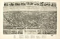
 Paterson NJ 1880.jpg 1,281 × 860; 1.05 MB
-
 Pennsylvania First colonization map.jpg 3,136 × 2,287; 3.31 MB
-
 Robert Hooper.jpg 635 × 1,019; 253 KB
-
 Rutherford 1904.jpg 558 × 366; 53 KB
-
 Toms River 1878.jpg 2,137 × 3,600; 643 KB
-
 Township Act of 1798.pdf 1,272 × 1,650, 14 pages; 1.91 MB
-
 Women's Club of Morristown.jpg 3,050 × 4,440; 2.72 MB
-
 Wpdms ev26188 lowernewyorkbay.jpg 365 × 236; 22 KB
_(page_1_crop).jpg)


.jpg)


.jpg)

_(14736596256).jpg)


.jpeg)

.jpg)


.jpg)


