Category:Hochstudhaus, Bowil
Jump to navigation
Jump to search
| Object location | | View all coordinates using: OpenStreetMap |
|---|
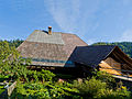
rural residential building in Bowil in the canton of Bern, Switzerland  | |||||
| Upload media | |||||
| Instance of | |||||
|---|---|---|---|---|---|
| Part of | |||||
| Location | Bowil, Bern-Mittelland administrative district, Bernese Mittelland administrative region, Bern, Switzerland | ||||
| Street address |
| ||||
| Heritage designation | |||||
| Inception |
| ||||
| Elevation above sea level |
| ||||
 | |||||
Media in category "Hochstudhaus, Bowil"
The following 2 files are in this category, out of 2 total.
-
 Bowil Höchstudhus.jpg 3,573 × 2,680; 1.19 MB
-
 Bowil Höchstudhus2.jpg 3,750 × 2,813; 1.95 MB
