Category:Housing in Wetherby
Jump to navigation
Jump to search
Subcategories
This category has the following 7 subcategories, out of 7 total.
- Homelessness in Wetherby (2 F)
T
Media in category "Housing in Wetherby"
The following 33 files are in this category, out of 33 total.
-
 A strangely placed house and the Crown Inn, High Street, Wetherby (15th April 2013).JPG 3,872 × 2,176; 2.35 MB
-
 Ainsty Drive - Ainsty Road - geograph.org.uk - 1173474.jpg 640 × 442; 196 KB
-
 Ainsty Garth, Wetherby (31st March 2013).jpg 3,580 × 1,981; 987 KB
-
 Ainsty View - Ainsty Road - geograph.org.uk - 1173470.jpg 640 × 480; 293 KB
-
 Aire Mount - Aire Road - geograph.org.uk - 1173583.jpg 640 × 436; 202 KB
-
 Aire Road, Wetherby (31st March 2013).jpg 3,872 × 2,176; 1.38 MB
-
 Aire Road, Wetherby (May 2010) 001.jpg 3,872 × 2,592; 2.73 MB
-
 Badger Wood Glade - Deighton Road - geograph.org.uk - 1173639.jpg 640 × 443; 221 KB
-
 Council houses on Ainsty Crescent.jpg 1,600 × 1,200; 621 KB
-
 Deerstone Ridge - Deighton Road - geograph.org.uk - 1173636.jpg 640 × 425; 242 KB
-
 Don Avenue - Nidd Approach - geograph.org.uk - 1173598.jpg 640 × 425; 200 KB
-
 Don Avenue, Wetherby (31st March 2013).jpg 3,872 × 2,176; 2.1 MB
-
 Hawthorne Avenue - Ainsty Road - geograph.org.uk - 1173569.jpg 640 × 480; 253 KB
-
 Hudson's Field, Wetherby (27th August 2010) 004.jpg 3,648 × 2,736; 2.53 MB
-
 Kings Meadow Close - Ainsty Road - geograph.org.uk - 1173572.jpg 640 × 435; 200 KB
-
 Kings Meadow View - Ainsty Road - geograph.org.uk - 1173574.jpg 640 × 446; 221 KB
-
 Kings Meadows, Wetherby (12th October 2013).JPG 3,872 × 2,176; 2.28 MB
-
 Lacy Avenue - geograph.org.uk - 1174037.jpg 640 × 440; 159 KB
-
 Nidd Approach - viewed from Aire Road - geograph.org.uk - 1173587.jpg 640 × 414; 175 KB
-
 Nidd Approach, Wetherby (31st March 2013).jpg 3,872 × 2,176; 2.07 MB
-
 North Grove Approach, Wetherby (March 2010) 001.jpg 3,648 × 2,736; 1.68 MB
-
 North Grove Aprroach, Wetherby (1st February 2012).JPG 3,872 × 2,176; 2.9 MB
-
 Nursery Garth, Wetherby (15th April 2013) 001.JPG 3,872 × 2,176; 1.98 MB
-
 Nursery Garth, Wetherby (15th April 2013) 002.JPG 3,872 × 2,176; 1.36 MB
-
 Oakwood Road, Wetherby (4th May 2010) 001.jpg 3,872 × 2,592; 2.92 MB
-
 Oakwood Road, Wetherby (4th May 2010) 002.jpg 3,872 × 2,592; 2.61 MB
-
 Orchard View - Deighton Road - geograph.org.uk - 1173635.jpg 640 × 480; 278 KB
-
 Recently conversted residential properties, Westgate, Wetherby (28th December 2018).jpg 5,152 × 3,864; 6.27 MB
-
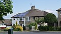 Solar panels on a 1930s semi on Barleyfields Road, Wetherby (31st May 2013).JPG 3,872 × 2,176; 2.07 MB
-
 Swale Rise - Ouse Drive - geograph.org.uk - 1173595.jpg 640 × 423; 206 KB
-
 Victoria Street, Wetherby 002.jpg 3,264 × 2,448; 1.02 MB
-
 Wetherby Young Offenders Institution (30th October 2010).jpg 3,648 × 2,736; 1.56 MB
-
 Wharfe Grange - Spofforth Hill - geograph.org.uk - 1174342.jpg 640 × 480; 232 KB
.JPG)

.jpg)


.jpg)
_001.jpg)


.jpg)

_004.jpg)


.JPG)


.jpg)
_001.jpg)
.JPG)
_001.JPG)
_002.JPG)
_001.jpg)
_002.jpg)

.jpg)
.JPG)


.jpg)
