Category:Husaren-Kaserne (Ratibor-Ostrog)
Jump to navigation
Jump to search
| Object location | | View all coordinates using: OpenStreetMap |
|---|
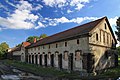
Polski: Racibórz, ul. Zamkowa 13 - budynek dawnych pruskich koszar wojskowych (1868-1877), ujeżdżalnie i stajnie

| NO WIKIDATA ID FOUND! Search for Husaren-Kaserne (Ratibor-Ostrog) on Wikidata | |
| Upload media |
Media in category "Husaren-Kaserne (Ratibor-Ostrog)"
The following 8 files are in this category, out of 8 total.
-
 7 Racibórz stajnie 6 pułku huzarów.JPG 2,288 × 1,712; 625 KB
-
 Budynek dawnych koszar wojskowych w Raciborzu 1.JPG 4,566 × 3,044; 9.28 MB
-
 Budynek dawnych koszar wojskowych w Raciborzu 2.JPG 4,152 × 2,768; 7.93 MB
-
 Budynek dawnych koszar wojskowych w Raciborzu 3.JPG 4,219 × 2,813; 8.68 MB
-
 Budynek dawnych koszar wojskowych w Raciborzu 4.JPG 4,752 × 3,168; 11.29 MB
-
 Kampania 1815 PA270006.JPG 2,288 × 1,712; 701 KB
-
 POL Racibórz Ostrog budynek.JPG 2,000 × 1,500; 897 KB
-
 Racibórz malowidło nad wejściem do stajni 6 pułku huzarów.JPG 2,288 × 1,712; 688 KB


