Category:Interstate 17
Jump to navigation
Jump to search
 | number: | (seventeen) |
|---|---|---|
| Interstate Highways: | 1 · 2 · 3 · 4 · 5 · 7 · 8 · 9 · 10 · 11 · 12 · 14 · 15 · 16 · 17 · 19 · 20 · 22 · 24 · 25 · 26 · 27 · 29 · 30 · 35 · 37 |
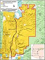
Interstate Highway in Maricopa, Yavapai, and Coconino counties in Arizona, United States  .svg)  | |||||
| Upload media | |||||
| Instance of | |||||
|---|---|---|---|---|---|
| Location |
| ||||
| Transport network | |||||
| Owned by | |||||
| Maintained by | |||||
| Length |
| ||||
| Terminus | |||||
 | |||||
English: Media related to Interstate 17 (Arizona Veterans Highway), a 145.76-mile (234.58 km) Interstate Highway in Maricopa, Yavapai, and Coconino counties in Arizona, United States.
Subcategories
This category has the following 4 subcategories, out of 4 total.
S
- Interstate 17 shields (10 F)
T
- The Stack (3 F)
Media in category "Interstate 17"
The following 66 files are in this category, out of 66 total.
-
 Agfr map.jpg 550 × 733; 85 KB
-
 Arcosanti-Map.jpg 847 × 1,024; 125 KB
-
 Arizona State Route 143 map.png 2,205 × 1,286; 73 KB
-
 Deer Valley, AZ, Approaching the Loop 101 Highway, 2012 - panoramio.jpg 4,000 × 3,000; 4.52 MB
-
 Hwy 17 overlooking Horse Thief Basin area north of Phoenix, AZ - 2023-3-16.jpg 3,396 × 2,360; 2.82 MB
-
 I-17 North - 6 MIles to Black Canyon City (49160223853).jpg 3,600 × 2,400; 3.08 MB
-
 I-17 North - Black Canyon Freeway Sign - MM203 (49160938417).jpg 3,600 × 2,400; 2.88 MB
-
 I-17 North - Black Canyon Freeway Sign - MM206 (49160700851).jpg 3,600 × 2,400; 2.66 MB
-
 I-17 North - Brushfire Danger High Sign (49160225313).jpg 3,600 × 2,400; 2.91 MB
-
 I-17 North - Camelback Road - Large Wrong Way Sign (49160938772).jpg 3,600 × 2,400; 3.05 MB
-
 I-17 North - Entering Yavapai County (49160708941).jpg 3,600 × 2,400; 3.55 MB
-
 I-17 North - Exit 201 - US60 West (49160702846).jpg 3,600 × 2,400; 2.98 MB
-
 I-17 North - Exit 212 - Bell Road (49160704131).jpg 3,600 × 2,400; 3.12 MB
-
 I-17 North - Exit 212 - Bell Road 0.25 Mile (49160939137).jpg 3,600 × 2,400; 2.99 MB
-
 I-17 North - Exit 214AB - Union HIlls Yorkshire (49160221098).jpg 3,600 × 2,400; 3.09 MB
-
 I-17 North - Exit 218 - Happy Valley Road (49160221838).jpg 3,600 × 2,400; 2.93 MB
-
 I-17 North - Exit 221 - AZ303 (49160706066).jpg 3,600 × 2,400; 2.87 MB
-
 I-17 North - Exit 223AB - AZ74 0.75 MIle (49160705786).jpg 3,600 × 2,400; 2.91 MB
-
 I-17 North - Exit 223B - AZ74 West (49160706416).jpg 3,600 × 2,400; 3.16 MB
-
 I-17 North - Exit 236 - Table Mesa Road - 1 MIle (49160706606).jpg 3,600 × 2,400; 3.13 MB
-
 I-17 North - Exit 242 - Black Canyon City (49160709211).jpg 3,600 × 2,400; 3.35 MB
-
 I-17 North - MM215 - AZ101 Bridges (49160704666).jpg 3,600 × 2,400; 2.56 MB
-
 I-17 North - MM227 - Donkeys Next 10 Miles (49160935842).jpg 3,600 × 2,400; 3.15 MB
-
 I-17 North - MM229 - Cacti in Median (49160941997).jpg 3,600 × 2,400; 3.06 MB
-
 I-17 North - MM238 (49160943327).jpg 3,600 × 2,400; 3.3 MB
-
 I-17 North - MM240 (49160708341).jpg 3,600 × 2,400; 3.54 MB
-
 I-17 North - Moores Gulch (49160707786).jpg 3,600 × 2,400; 3.43 MB
-
 I-17 North - Near Table Mesa (49160707446).jpg 3,600 × 2,400; 3.6 MB
-
 I-17 North Sign - MM219 (49160940882).jpg 3,600 × 2,400; 2.8 MB
-
 I-17 North Sign - MM237 (49160223603).jpg 3,600 × 2,400; 3.21 MB
-
 I-17 North US60 West - Exit 200A - Interstate 10 (49160702496).jpg 3,600 × 2,400; 2.93 MB
-
 I-17 South - AZ74 17 Miles - Phoneix 43 (49160946567).jpg 3,600 × 2,400; 3.04 MB
-
 I-17 South - Elevation 2000 Feet at New River (49160228053).jpg 3,600 × 2,400; 3.3 MB
-
 I-17 South - Exit 214C - AZ101 (49160712076).jpg 3,600 × 2,400; 3.47 MB
-
 I-17 South - Exit 221 - AZ303 South (49160711721).jpg 3,600 × 2,400; 3.07 MB
-
 I-17 South - Exit 223 - AZ74 West (49160228208).jpg 3,600 × 2,400; 2.56 MB
-
 I-17 South Ramp - AZ101 Signs (49160947952).jpg 3,600 × 2,400; 3.18 MB
-
 I-40 in Arizona towards LA.jpg 4,320 × 3,240; 4.77 MB
-
 I17 mystery treejpg.jpg 1,600 × 1,281; 1.17 MB
-
 Interchange-2Loop 101 and Interstate 17 Interchange (6) (4984020181).jpg 6,346 × 4,136; 5.1 MB
-
 Interstate 10 and Interstate 17 Interchange at Night (1) (8115296401).jpg 10,349 × 4,657; 11.95 MB
-
 Interstate 10 and Interstate 17 Interchange at Night (3) (8115295825).jpg 2,456 × 1,601; 1.09 MB
-
 Interstate 17 map.png 2,205 × 1,239; 79 KB
-
 Interstate 17 Signs (49160709436).jpg 3,600 × 2,400; 2.66 MB
-
 Interstate 17 southern terminus in Phoenix.jpg 600 × 441; 61 KB
-
 Interstate 17, Arizona.jpg 2,284 × 1,520; 833 KB
-
 Loop 101 and Interstate 17 Interchange (1) (4984625904).jpg 6,872 × 4,202; 8.42 MB
-
 Loop 101 and Interstate 17 Interchange (2) (4984623762).jpg 5,698 × 3,476; 6.18 MB
-
 Loop 101 and Interstate 17 Interchange (2-cropped) (4984026203).jpg 3,557 × 2,272; 2.41 MB
-
 Loop 101 and Interstate 17 Interchange (3) (4984622180).jpg 4,747 × 3,084; 3.18 MB
-
 Loop 101 and Interstate 17 Interchange (4) (4984621480).jpg 7,855 × 5,840; 14.97 MB
-
 Loop 101 and Interstate 17 Interchange (5) (4984020789).jpg 4,133 × 2,670; 2.29 MB
-
 Loop 101 and Interstate 17 Interchange (7) (4984019459).jpg 5,120 × 3,231; 4.84 MB
-
 Loop 101 and Interstate 17 Interchange (8) (4987134975).jpg 2,886 × 4,180; 5.54 MB
-
 Loop 101 and Interstate 17 Interchange (9) (4987136527).jpg 6,242 × 5,117; 9.56 MB
-
 Loop 101 and Interstate 17 Interchange (9-cropped) (4987137073).jpg 4,023 × 2,580; 2.72 MB
-
-

-
 Near New River, AZ, Approaching the Carefree Highway, 2012 - panoramio.jpg 4,000 × 3,000; 4.36 MB
-
 New River, AZ, Approaching the Salt River Valley - Valley of the Sun, 2012 - panoramio.jpg 4,000 × 3,000; 3.97 MB
-
 Peterbilt, Along the Highway, Semi-Retired, AZ 7-31-13 (11501438143).jpg 1,750 × 1,511; 470 KB
-
 Phoenix, Arizona 1955 Yellow Book.jpg 800 × 539; 99 KB
-
 Phoenix, AZ, I17, View S Toward Maryland Ave. Pedestrian Bridge, 2012 - panoramio.jpg 4,000 × 3,000; 4.71 MB
-
 Phoenix, AZ, The Isaac Pedestrian Bridge at Night, 2011 - panoramio.jpg 4,000 × 3,000; 3.02 MB
-
 Phoenix-17th Ave. Underpass-1935.jpg 3,264 × 2,448; 1.77 MB
-
 Red Rock-Secret Mtn Wilderness Map.JPG 508 × 724; 59 KB


.jpg)
.jpg)
.jpg)
.jpg)
.jpg)
.jpg)
.jpg)
.jpg)
.jpg)
.jpg)
.jpg)
.jpg)
.jpg)
.jpg)
.jpg)
.jpg)
.jpg)
.jpg)
.jpg)
.jpg)
.jpg)
.jpg)
.jpg)
.jpg)
.jpg)
.jpg)
.jpg)
.jpg)
.jpg)
.jpg)
.jpg)
.jpg)


_(4984020181).jpg)
_(8115296401).jpg)
_(8115295825).jpg)
.jpg)

_(4984625904).jpg)
_(4984623762).jpg)
_(4984026203).jpg)
_(4984622180).jpg)
_(4984621480).jpg)
_(4984020789).jpg)
_(4984019459).jpg)
_(4987134975).jpg)
_(4987136527).jpg)
_(4987137073).jpg)


.jpg)


