Category:Kirkcudbright
Jump to navigation
Jump to search
town and former burgh in Kirkcudbrightshire, Dumfries and Galloway, Scotland, UK  | |||||
| Upload media | |||||
| Instance of |
| ||||
|---|---|---|---|---|---|
| Location |
| ||||
| Population |
| ||||
 | |||||
Subcategories
This category has the following 12 subcategories, out of 12 total.
A
B
- Buckland Burn (13 F)
C
K
- Kirkchrist Kirkyard (12 F)
- Kirkcudbright Bridge (58 F)
L
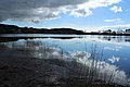
- Loch Fergus, Kirkcudbright (1 F)
M
- Maps of Kirkcudbright (6 F)
S
Media in category "Kirkcudbright"
The following 200 files are in this category, out of 232 total.
(previous page) (next page)-
 Ex Police Station, Kirkcudbright - geograph.org.uk - 6619033.jpg 2,976 × 1,984; 3.32 MB
-
 Kirkcudbright - geograph.org.uk - 2008543.jpg 3,648 × 2,736; 4.46 MB
-
 Kirkcudbright Telephone Exchange - geograph.org.uk - 2035276.jpg 1,600 × 1,200; 426 KB
-
 MacLellan's Castle, Kirkcudbright - geograph.org.uk - 4046964.jpg 1,920 × 1,280; 1.63 MB
-
 MacLellan's Castle, Kirkcudbright - geograph.org.uk - 4046974.jpg 1,920 × 1,280; 1.63 MB
-
 Rooflines and facades, Kirkcudbright - geograph.org.uk - 34792.jpg 512 × 640; 99 KB
-

-
 The Old Rectory, Kirkcudbright - geograph.org.uk - 5706402.jpg 2,976 × 1,984; 2.75 MB
-
 'Steam Packet Inn' near Kirkcudbright harbour - geograph.org.uk - 2401872.jpg 3,401 × 2,760; 4.11 MB
-
 Kirkcudbright in 1986 - geograph.org.uk - 2283827.jpg 886 × 637; 112 KB
-
 A quiet Afternoon - geograph.org.uk - 3761682.jpg 640 × 424; 86 KB
-
 A seat with a view - geograph.org.uk - 5512309.jpg 1,600 × 900; 297 KB
-
 A711 Junction - geograph.org.uk - 444613.jpg 640 × 480; 108 KB
-
 Across The Dee - geograph.org.uk - 5923624.jpg 640 × 404; 97 KB
-
 Across the mud from Black Moray Plantation - geograph.org.uk - 6296088.jpg 1,024 × 597; 102 KB
-
 Aerial view of Kirkcudbright & the River Dee (geograph 3644499).jpg 2,038 × 1,528; 1.41 MB
-
 Aerial view of Kirkcudbright and the River Dee (geograph 3644499).jpg 3,264 × 2,448; 3.28 MB
-
 Along the Embankment, Kirkcudbright. - geograph.org.uk - 2020019.jpg 1,000 × 750; 341 KB
-
 An encouraging message ... - geograph.org.uk - 4741638.jpg 3,870 × 2,848; 3.59 MB
-
 Arriving at The Stell - geograph.org.uk - 6119144.jpg 2,976 × 1,984; 3.24 MB
-
 B727 - geograph.org.uk - 462984.jpg 640 × 480; 74 KB
-
 B727 through Brockcleugh Woods - geograph.org.uk - 406402.jpg 640 × 480; 158 KB
-
 Balgreddan - geograph.org.uk - 677378.jpg 640 × 480; 68 KB
-
 Balmae House - geograph.org.uk - 343386.jpg 640 × 427; 125 KB
-
 Bank of Scotland, Kirkcudbright - geograph.org.uk - 5706663.jpg 2,892 × 1,864; 1.14 MB
-

-
 Barcloy Bridge - geograph.org.uk - 677394.jpg 640 × 480; 92 KB
-
 Beside the River Dee - geograph.org.uk - 5580410.jpg 1,600 × 1,019; 434 KB
-
 Bin Lorry, Kirkcudbright - geograph.org.uk - 5706300.jpg 2,976 × 1,984; 2.76 MB
-
 Black Stockerton Moor - geograph.org.uk - 1297771.jpg 640 × 480; 106 KB
-
 Boat on the Dee - geograph.org.uk - 679577.jpg 640 × 479; 102 KB
-
 Boat on the Dee, Kirkcudbright - geograph.org.uk - 3871802.jpg 1,920 × 1,280; 1.12 MB
-
 Boat on the Dee, Kirkcudbright - geograph.org.uk - 3871810.jpg 1,920 × 1,280; 1.59 MB
-
 Boat on the River Dee at Kircudbright - geograph.org.uk - 210620.jpg 640 × 425; 108 KB
-
 Boats on the River Dee, Kirkcudbright - geograph.org.uk - 6619076.jpg 2,976 × 1,984; 3.07 MB
-
 Bombie Farm - geograph.org.uk - 695412.jpg 640 × 480; 119 KB
-
 Bombie Glen - geograph.org.uk - 677280.jpg 640 × 480; 105 KB
-
 Bombie Glen House - geograph.org.uk - 695444.jpg 640 × 480; 117 KB
-
 Bombie Hill - geograph.org.uk - 736083.jpg 640 × 480; 84 KB
-
 Bridge over the River Dee, Kirkcudbright - geograph.org.uk - 3871567.jpg 1,920 × 1,280; 849 KB
-
 Brockcleuch - geograph.org.uk - 406419.jpg 640 × 480; 107 KB
-
 Buoy in the Dee - geograph.org.uk - 6278094.jpg 1,024 × 768; 270 KB
-
 By Castledykes - geograph.org.uk - 5559768.jpg 4,272 × 2,848; 4.81 MB
-
 Camphill, Whinnieliggate - geograph.org.uk - 677298.jpg 640 × 480; 78 KB
-
 Car Park, Kirkcudbright - geograph.org.uk - 4477704.jpg 1,920 × 1,280; 1.78 MB
-
 Car Park, Kirkcudbright - geograph.org.uk - 4621127.jpg 1,920 × 1,280; 1.75 MB
-
 Castellated Wall - geograph.org.uk - 5559896.jpg 4,272 × 2,848; 2.8 MB
-

-
 Coastline at Balmae Ha'en - geograph.org.uk - 324172.jpg 640 × 427; 138 KB
-
 Colin's Shed, Kirkcudbright (19993908088).jpg 3,456 × 4,608; 1.52 MB
-
 Corrugated iron shed sited near Parkgate - geograph.org.uk - 571760.jpg 640 × 480; 101 KB
-
 Daffodils beside the Dee - geograph.org.uk - 6119119.jpg 2,976 × 1,984; 3.14 MB
-
 Danger-Postbox - geograph.org.uk - 722701.jpg 640 × 480; 126 KB
-

-

-

-
 Dee Walk - geograph.org.uk - 5580378.jpg 1,067 × 1,600; 815 KB
-
 Dee Walk near Kirkcudbright - geograph.org.uk - 3686280.jpg 5,184 × 3,456; 7.55 MB
-
 Dee Walk near Kirkcudbright - geograph.org.uk - 3686283.jpg 1,600 × 1,067; 527 KB
-
 Derelict Boat by River Dee, Kirkcudbright - geograph.org.uk - 3686274.jpg 1,600 × 1,067; 478 KB
-
 Driveway entrance to Milton - geograph.org.uk - 572100.jpg 640 × 480; 130 KB
-
 Dromore Farm - geograph.org.uk - 722905.jpg 640 × 388; 47 KB
-
 Dunrod Church and Graveyard - geograph.org.uk - 694740.jpg 640 × 480; 82 KB
-
 Dunrod Church and Graveyard - geograph.org.uk - 736019.jpg 640 × 480; 98 KB
-
 Dunrod Homestead Moat - geograph.org.uk - 735995.jpg 640 × 480; 69 KB
-
 Dunrod Mill - geograph.org.uk - 694822.jpg 640 × 480; 110 KB
-

-
 Flooded Farmland near Cumstoun - geograph.org.uk - 3872426.jpg 1,920 × 1,280; 1.53 MB
-
 Flooded Farmland near Kirkcudbright - geograph.org.uk - 3872407.jpg 1,920 × 1,280; 1.5 MB
-
 Flooded Field near Kirkcudbright - geograph.org.uk - 3872387.jpg 1,920 × 1,280; 1.48 MB
-
 Gateway to Kirkcudbright Marina - geograph.org.uk - 5706615.jpg 2,976 × 1,984; 2.59 MB
-
 Gibbhill Point - geograph.org.uk - 4078889.jpg 640 × 385; 103 KB
-
 Gibbhill Point - Kirkcudbright - geograph.org.uk - 4084539.jpg 640 × 427; 101 KB
-
 Glenley Heugh - geograph.org.uk - 677276.jpg 640 × 480; 105 KB
-
 Grange Hill - geograph.org.uk - 722973.jpg 640 × 480; 81 KB
-
 Gribdae Burn Hills - geograph.org.uk - 695360.jpg 640 × 480; 101 KB
-
 Gribdae Farm - geograph.org.uk - 695341.jpg 640 × 480; 109 KB
-
 Gribdae Lane - geograph.org.uk - 695386.jpg 640 × 480; 152 KB
-
 Gypsy Point - geograph.org.uk - 343151.jpg 640 × 427; 139 KB
-
 Gypsy point - geograph.org.uk - 343732.jpg 512 × 640; 220 KB
-
 High Kirkland - geograph.org.uk - 307495.jpg 640 × 429; 161 KB
-
 Inverdee, The Stell - geograph.org.uk - 4904766.jpg 3,436 × 2,260; 2.98 MB
-
 Jetty, Kirkcudbright - geograph.org.uk - 6619054.jpg 2,976 × 1,984; 2.98 MB
-
 Jetty, Kirkcudbright - geograph.org.uk - 6619061.jpg 2,976 × 1,984; 3.03 MB
-
 Jetty, Kirkcudbright - geograph.org.uk - 6619066.jpg 2,976 × 1,984; 2.71 MB
-
 Jetty, Kirkcudbright - geograph.org.uk - 6619070.jpg 2,976 × 1,984; 2.63 MB
-
 Jetty, Kirkcudbright - geograph.org.uk - 6619078.jpg 2,976 × 1,984; 2.81 MB
-
 Just a striking piece of wood. - geograph.org.uk - 211058.jpg 640 × 425; 144 KB
-
 Just berthed - geograph.org.uk - 5372898.jpg 4,896 × 3,264; 6.86 MB
-
 Keep Out - geograph.org.uk - 722789.jpg 640 × 480; 126 KB
-
 Kirkcudbright - geograph.org.uk - 5707317.jpg 2,976 × 1,984; 927 KB
-
 Kirkcudbright - geograph.org.uk - 6159851.jpg 1,024 × 768; 202 KB
-
 Kirkcudbright - panoramio.jpg 3,872 × 2,592; 5.84 MB
-
 Kirkcudbright across the River Dee - geograph.org.uk - 2928662.jpg 1,067 × 1,600; 370 KB
-
 Kirkcudbright and the River Dee - geograph.org.uk - 5580342.jpg 1,600 × 952; 372 KB
-
 Kirkcudbright Cemetery - geograph.org.uk - 698536.jpg 640 × 480; 102 KB
-
 Kirkcudbright Marina - geograph.org.uk - 5706618.jpg 2,976 × 1,984; 2.43 MB
-
 Kirkcudbright Marina - geograph.org.uk - 6119116.jpg 2,976 × 1,984; 2.7 MB
-
 Kirkcudbright Marina - geograph.org.uk - 6610312.jpg 640 × 458; 69 KB
-
 Kirkcudbright Marina View - geograph.org.uk - 5923673.jpg 640 × 377; 88 KB
-
 Kirkcudbright Town - geograph.org.uk - 6543231.jpg 2,976 × 1,984; 2.86 MB
-
 Kirkeoch farm and steading - geograph.org.uk - 2124535.jpg 1,024 × 768; 145 KB
-
 Knockbrex Toy Fort, Kirkcudbright, 1.jpg 3,024 × 4,032; 11.95 MB
-
 Knockbrex Toy Fort, Kirkcudbright, 2.jpg 3,939 × 2,954; 13.6 MB
-
 Little Gregory lane - geograph.org.uk - 694783.jpg 640 × 480; 67 KB
-
 Manxman's Lake - geograph.org.uk - 6615544.jpg 2,976 × 1,984; 2.43 MB
-
 Manxman's Lake - geograph.org.uk - 6615547.jpg 2,976 × 1,984; 2.69 MB
-
 Manxman's Lake - geograph.org.uk - 6615551.jpg 2,976 × 1,984; 2.38 MB
-

-
 Moorings on the River Dee - geograph.org.uk - 5706572.jpg 2,976 × 1,886; 851 KB
-
 Moorings on the River Dee - geograph.org.uk - 5706573.jpg 2,976 × 1,984; 2.65 MB
-
 Moorings on the River Dee - geograph.org.uk - 5706594.jpg 2,976 × 1,984; 1.23 MB
-
 Moorings on the River Dee - geograph.org.uk - 5706595.jpg 2,976 × 1,984; 3.29 MB
-
 Moorings on the River Dee - geograph.org.uk - 5706597.jpg 2,976 × 1,984; 2.64 MB
-
 Mudflats at the River Dee - geograph.org.uk - 4423177.jpg 1,920 × 1,280; 1.49 MB
-
 Mudflats at the River Dee - geograph.org.uk - 4423264.jpg 1,920 × 1,280; 2.23 MB
-
 Mudflats at the River Dee - geograph.org.uk - 4423280.jpg 1,920 × 1,280; 1.25 MB
-

-
 Mutehill Cottage - geograph.org.uk - 3686960.jpg 1,600 × 1,067; 526 KB
-
 Path and Daffodils - geograph.org.uk - 5313291.jpg 2,592 × 1,728; 2.96 MB
-
 Path at the River Dee - geograph.org.uk - 5706523.jpg 2,976 × 1,984; 4.09 MB
-
 Path to Tongland Old Bridge - geograph.org.uk - 3872376.jpg 1,920 × 1,280; 1.71 MB
-
 Path to Tongland Old Bridge - geograph.org.uk - 3872396.jpg 1,920 × 1,280; 1.53 MB
-
 Path to Tongland Old Bridge at Kirkcudbright - geograph.org.uk - 3871758.jpg 1,920 × 1,280; 2.08 MB
-
 Path to Tongland Old Bridge with Seat - geograph.org.uk - 3872419.jpg 1,920 × 1,280; 1.89 MB
-
 Police Station, Kirkcudbright - geograph.org.uk - 5706378.jpg 2,919 × 1,870; 1,010 KB
-
 Pontoons at the Dee - geograph.org.uk - 5706598.jpg 2,976 × 1,984; 2.27 MB
-
 Pontoons at the Dee - geograph.org.uk - 5706611.jpg 2,976 × 1,984; 3.21 MB
-
 Pontoons at the Dee - geograph.org.uk - 5706613.jpg 2,976 × 1,984; 2.89 MB
-
 Pontoons at the Dee, Kirkcudbright - geograph.org.uk - 6138504.jpg 2,976 × 1,984; 3.02 MB
-
 Pool beside the River Dee - geograph.org.uk - 5580368.jpg 1,600 × 1,067; 403 KB
-
 Reed beds beside the River Dee - geograph.org.uk - 5580325.jpg 1,600 × 1,018; 357 KB
-
 River Dee - geograph.org.uk - 281474.jpg 640 × 480; 68 KB
-
 River Dee - geograph.org.uk - 5706503.jpg 2,976 × 1,984; 4.51 MB
-
 River Dee - geograph.org.uk - 5706507.jpg 2,976 × 1,984; 5.28 MB
-
 River Dee - geograph.org.uk - 5706520.jpg 2,976 × 1,984; 3.66 MB
-
 River Dee - geograph.org.uk - 5706522.jpg 2,976 × 1,984; 2.8 MB
-
 River Dee - geograph.org.uk - 5706553.jpg 2,976 × 1,984; 3.57 MB
-
 River Dee - geograph.org.uk - 5706555.jpg 2,976 × 1,984; 3.31 MB
-
 River Dee - geograph.org.uk - 5706560.jpg 2,976 × 1,984; 3.51 MB
-
 River Dee - geograph.org.uk - 5706565.jpg 2,976 × 1,984; 3.07 MB
-
 River Dee - geograph.org.uk - 5706567.jpg 2,976 × 1,984; 3.05 MB
-
 River Dee - geograph.org.uk - 5706571.jpg 2,976 × 1,984; 3.15 MB
-
 River Dee - geograph.org.uk - 5706576.jpg 2,976 × 1,984; 2.44 MB
-
 River Dee - geograph.org.uk - 5706592.jpg 2,976 × 1,984; 3.07 MB
-
 River Dee - geograph.org.uk - 5706599.jpg 2,976 × 1,984; 2.29 MB
-
 River Dee - geograph.org.uk - 5706601.jpg 2,976 × 1,984; 2.72 MB
-
 River Dee looking towards Castledykes Point - geograph.org.uk - 2657669.jpg 3,689 × 2,682; 1.69 MB
-

-
 River Dee low water - geograph.org.uk - 600117.jpg 640 × 480; 40 KB
-
 River Dee Mudflats - geograph.org.uk - 600170.jpg 640 × 480; 42 KB
-
 River Dee near Cumstoun - geograph.org.uk - 3872421.jpg 1,920 × 1,280; 1.36 MB
-
 River Dee shoreline - geograph.org.uk - 600171.jpg 640 × 480; 50 KB
-
 River Dee View - geograph.org.uk - 5923617.jpg 640 × 404; 88 KB
-
 River Dee, Kirkcudbright - geograph.org.uk - 3573856.jpg 640 × 360; 232 KB
-
 River Dee, Kirkcudbright - geograph.org.uk - 3871571.jpg 1,920 × 1,280; 889 KB
-
 River Dee, Kirkcudbright - geograph.org.uk - 3871754.jpg 1,920 × 1,280; 1.03 MB
-
 River Dee, Kirkcudbright - geograph.org.uk - 3871779.jpg 1,920 × 1,280; 1.58 MB
-
 River Dee, Kirkcudbright - geograph.org.uk - 3871811.jpg 1,920 × 1,280; 2.33 MB
-
 River Dee, Kirkcudbright - geograph.org.uk - 3871826.jpg 1,920 × 1,280; 1.63 MB
-
 River Dee, Kirkcudbright - geograph.org.uk - 3871833.jpg 1,920 × 1,280; 1.12 MB
-
 River Dee, Kirkcudbright - geograph.org.uk - 3871988.jpg 1,920 × 1,280; 1.51 MB
-
 River Dee, Kirkcudbright - geograph.org.uk - 3872382.jpg 1,920 × 1,280; 1.18 MB
-
 River Dee, Kirkcudbright - geograph.org.uk - 3872402.jpg 1,920 × 1,280; 1.2 MB
-
 River Dee, Kirkcudbright - geograph.org.uk - 5313274.jpg 2,592 × 1,728; 2.1 MB
-
 River Dee, Kirkcudbright - geograph.org.uk - 5313287.jpg 2,592 × 1,728; 1.93 MB
-
 River Dee, Kirkcudbright - geograph.org.uk - 5313303.jpg 2,592 × 1,728; 1.96 MB
-
 River Dee, Kirkcudbright - geograph.org.uk - 5313304.jpg 2,592 × 1,728; 2.4 MB
-
 Riverbank walk - geograph.org.uk - 406426.jpg 640 × 480; 157 KB
-
 Road junction at Townhead - geograph.org.uk - 571920.jpg 640 × 480; 110 KB
-
 Road to Borgue - geograph.org.uk - 6119120.jpg 2,976 × 1,984; 889 KB
-
 Rough field near Townhead - geograph.org.uk - 572099.jpg 640 × 480; 102 KB
-
 Sandside Cottage - geograph.org.uk - 2124846.jpg 768 × 1,024; 278 KB
-
 Seat by the River Dee, Kirkcudbright - geograph.org.uk - 3871820.jpg 1,920 × 1,280; 1.53 MB
-
 Seating Area, Kirkcudbright - geograph.org.uk - 5313290.jpg 2,592 × 1,728; 2.71 MB
-
 Shades of blue and grey - geograph.org.uk - 2136324.jpg 1,024 × 768; 189 KB
-
 Sheep on the Merse - geograph.org.uk - 3761676.jpg 640 × 424; 105 KB
-
 Shore by the River Dee - geograph.org.uk - 3822870.jpg 640 × 375; 60 KB
-
 Shoreline, Bishopton - geograph.org.uk - 6159843.jpg 1,024 × 768; 260 KB
-
 Slipway at Gibb Hill Point - geograph.org.uk - 2124526.jpg 768 × 1,024; 211 KB
-
 Slipway at the Dee, Kirkcudbright - geograph.org.uk - 3874100.jpg 1,920 × 1,280; 1.39 MB
-
 Slipway, Kirkcudbright - geograph.org.uk - 5706614.jpg 2,976 × 1,984; 2.87 MB
-
 The River Dee (Kirkcudbright) Salmon Fishery District (Baits and Lures) Regulations 2002 (SSI 2002-11 qp).pdf 1,239 × 1,754, 2 pages; 35 KB
-
 The River Dee (Kirkcudbright) Salmon Fishery District (Baits and Lures) Regulations 2002 (SSI 2002-11).pdf 1,239 × 1,752, 3 pages; 126 KB
-
 St Mary's Isle Shore - geograph.org.uk - 5927252.jpg 640 × 414; 128 KB
-
 Stage for Kirkcudbright Summer Festivities - geograph.org.uk - 4047174.jpg 1,920 × 1,280; 1.41 MB
-
 The A702 near Kirkcudbright Farm - geograph.org.uk - 399182.jpg 640 × 480; 112 KB
-
 The A711 road west of Dundrennan - geograph.org.uk - 572544.jpg 640 × 480; 127 KB
-
 The Antique Shop, Kirkcudbright - geograph.org.uk - 5475250.jpg 2,516 × 1,658; 724 KB
-
 The Dee at Kirkcudbright - geograph.org.uk - 6138571.jpg 2,976 × 1,984; 2.77 MB
-
 The Dee estuary - geograph.org.uk - 5516939.jpg 1,600 × 900; 284 KB
-
 The Dee estuary near to Parkgate - geograph.org.uk - 571753.jpg 640 × 480; 128 KB
-
 The Dee Walk near Cumstoun - geograph.org.uk - 3872423.jpg 1,920 × 1,280; 2.23 MB
-
 The Dee Walk Path at Kirkcudbright - geograph.org.uk - 3871789.jpg 1,920 × 1,280; 1.89 MB
-
 The Dee Walk Path to Kirkcudbright - geograph.org.uk - 3872390.jpg 1,920 × 1,280; 2.06 MB
-
 The Dee Walk Path to Kirkcudbright - geograph.org.uk - 3872415.jpg 1,920 × 1,280; 1.95 MB
-
 The Jetty at Kirkcudbright Harbour - geograph.org.uk - 6615241.jpg 2,976 × 1,984; 2.2 MB
-
 The River Dee - geograph.org.uk - 4929430.jpg 800 × 600; 89 KB
-
 The River Dee - geograph.org.uk - 6138574.jpg 2,976 × 1,984; 2.81 MB
-
 The River Dee - geograph.org.uk - 6138575.jpg 2,976 × 1,984; 2.71 MB


.jpg)
.jpg)


.jpg)


,_een_schilder_die_in_Kirkcudbright_woont_met_onder_and,_Bestanddeelnr_190-1131.jpg)
,_een_schilder_die_in_Kirkcudbright_woont_met_onder_and,_Bestanddeelnr_190-1132.jpg)
,_een_schilder_die_in_Kirkcudbright_woont_met_onder_and,_Bestanddeelnr_190-1133.jpg)


