Category:Kongur
Jump to navigation
Jump to search
mountain  Pohled na jižní stěnu | |||||
| Upload media | |||||
| Instance of | |||||
|---|---|---|---|---|---|
| Part of | |||||
| Location | Akto County, Kizilsu Kyrgyz Autonomous Prefecture, Xinjiang, PRC | ||||
| Significant event |
| ||||
| Mountain range |
| ||||
| Topographic prominence |
| ||||
| Topographic isolation |
| ||||
| Elevation above sea level |
| ||||
 | |||||
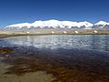
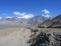
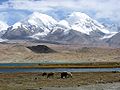
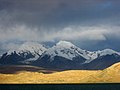
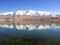
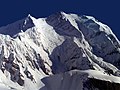
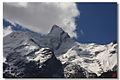
English: Kongur Tagh Mountain of the Pamir Mountains — in the Xinjiang Uygur Autonomous Region of western China, Central Asia. Height: 7649 m. Near Karakul lake, and close to the Karakoram Highway.
中文(简体):公格尔峰
Español: Monte Kongur junto al Lago Karakul, en la Autopista del Karakórum en la provincia de Xinjiang (China).
Media in category "Kongur"
The following 24 files are in this category, out of 24 total.
-
-

-

-

-

-

-

-

-

-

-

-

-

-
 Karakorum-d07.jpg 1,024 × 768; 200 KB
-
 Karakul-kongur-d06.jpg 1,024 × 768; 166 KB
-
 Karakul-kongur-d09.jpg 1,024 × 768; 111 KB
-
 Karakul-kongur-d11.jpg 1,024 × 768; 132 KB
-
 Kongur II Range.jpg 1,024 × 768; 433 KB
-
 Kongur Shan (3to4).jpg 927 × 695; 367 KB
-
 Kongur Shan.jpg 1,024 × 768; 463 KB
-
 Kongur south (3to4).jpg 800 × 600; 126 KB
-
 Kongur south.jpg 900 × 600; 115 KB
-
 Mt Kongur Lake Karakul Xinjiang China.jpg 900 × 445; 91 KB
-
 公格尔雪峰 - panoramio.jpg 1,100 × 736; 296 KB

.jpg)

.jpg)

.jpg)
.jpg)
.jpg)


.jpg)

.jpg)


.jpg)
.jpg)