Category:Kontrollgebäude Biel/Bienne
Jump to navigation
Jump to search
| Object location | | View all coordinates using: OpenStreetMap |
|---|
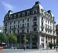
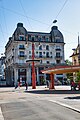
former residential / commercial building and current administration building in Bienne in the canton of Bern, Switzerland  | |||||
| Upload media | |||||
| Instance of | |||||
|---|---|---|---|---|---|
| Part of | |||||
| Location | New City South, Biel/Bienne, Biel/Bienne administrative district, Seeland administrative region, Bern, Switzerland | ||||
| Located in or next to body of water | |||||
| Street address |
| ||||
| Architectural style | |||||
| Architect |
| ||||
| Manufacturer | |||||
| Heritage designation | |||||
| Inception |
| ||||
| Area |
| ||||
| Elevation above sea level |
| ||||
 | |||||
Media in category "Kontrollgebäude Biel/Bienne"
The following 13 files are in this category, out of 13 total.
-
 Biel - Bienne - panoramio (2).jpg 4,272 × 2,848; 7.96 MB
-
 Biel - Kontrollgebäude.jpg 1,490 × 1,351; 412 KB
-
 Kontrollgebaeude Biel.jpg 3,456 × 5,184; 10.3 MB
-
 Kontrollgebaeude, Biel 01 10.jpg 1,575 × 1,049; 808 KB
-
 Kontrollgebaeude, Biel 02 10.jpg 1,575 × 1,049; 778 KB
-
 Kontrollgebäude 2139 am Zentralplatz mit Oberer Quai, Biel, Juni 2022.jpg 3,200 × 2,250; 2.75 MB
-
 Kontrollgebäude Biel BE 01.jpg 3,168 × 4,752; 6.21 MB
-
 Kontrollgebäude Biel BE 02.jpg 4,752 × 3,168; 13.89 MB
-
 Kontrollgebäude Biel BE 03.jpg 3,720 × 4,344; 4.52 MB
-
 Kontrollgebäude Biel BE 04.jpg 4,752 × 3,168; 11.59 MB
-
 Kontrollgebäude Biel BE 05.jpg 3,168 × 4,752; 10.98 MB
-
 Kontrollgebäude Biel BE 06.jpg 3,168 × 4,752; 6.58 MB
-
 Röstigraben.jpg 2,048 × 1,536; 1.74 MB
.jpg)


Categories:
- Public buildings in Biel/Bienne
- Cultural properties of national significance in Biel/Bienne
- Historicist architecture in the canton of Bern
- Office buildings in Biel/Bienne
- Zentralplatz/Place Centrale (Biel/Bienne)
- Zentralstrasse/Rue Centrale (Biel/Bienne)
- Oberer Quai/Quai du Haut (Biel/Bienne)
- Léon Fulpius (architect)