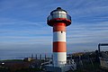
Category:Lühe range front light
Jump to navigation
Jump to search
| Object location | | View all coordinates using: OpenStreetMap |
|---|
lighthouse in Lower Saxony, Germany  | |||||
| Upload media | |||||
| Instance of | |||||
|---|---|---|---|---|---|
| Part of |
| ||||
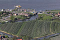
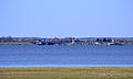
| Location | Lühe, Stade, Lower Saxony, Germany | ||||
| Located in or next to body of water | |||||
| Inception |
| ||||
| Height |
| ||||
 | |||||
Media in category "Lühe range front light"
The following 13 files are in this category, out of 13 total.
-
 Aerial photograph 8393 DxO.jpg 5,184 × 3,456; 4.81 MB
-
 Aerial photograph 8395 DxO.jpg 5,184 × 3,456; 4.52 MB
-
 Aerial photograph 8396 DxO.jpg 5,184 × 3,456; 4.34 MB
-
 Aerial photograph 8397 DxO.jpg 5,184 × 3,456; 4.29 MB
-
 Aerial photograph 8398 DxO.jpg 5,184 × 3,456; 5.48 MB
-
 Altes Land IMG 2634 DxO.jpg 1,024 × 682; 96 KB
-
 Luehe-Anleger 21.JPG 3,661 × 2,441; 5.01 MB
-
 Luftaufnahmen Nordseekueste 2012-05-by-RaBoe-572.jpg 4,000 × 2,657; 7.82 MB
-
 Luhe range front 1981.jpg 5,472 × 3,648; 2.31 MB
-
 Luhe range front 1983.jpg 2,432 × 3,647; 1.21 MB
-
 Lühe (Jork) 01.jpg 4,513 × 2,691; 8.83 MB
-
 Lühe (Jork) 02.jpg 4,529 × 2,835; 9.07 MB
-
 Lühne 2007 -Unterfeuer- by-RaBoe 002.jpg 1,128 × 722; 786 KB


_01.jpg)
_02.jpg)
Categories:
- Lighthouses in Germany by name
- Lighthouses in Lower Saxony
- Range lights in Germany
- Lighthouses by height, 11 to 20 meters
- Lighthouses built in 1970
- Wasserstraßen- und Schifffahrtsamt Hamburg
- Grünendeich
- Steel lighthouses
- Red and white lighthouses in Germany
- Towers in Landkreis Stade
- Lighthouses by range, 10 to 14 nm