Category:Laysters (civil parish)
Jump to navigation
Jump to search
English: Laysters is a civil parish in the county of Herefordshire, England. Not to be confused with the hamlet of Laysters Pole (Leysters) in the adjacent parish of Middleton on the Hill.
civil parish in Herefordshire, England .jpg) | |||||
| Upload media | |||||
| Instance of | |||||
|---|---|---|---|---|---|
| Location | Herefordshire, West Midlands, England | ||||
 | |||||
Media in category "Laysters (civil parish)"
The following 65 files are in this category, out of 65 total.
-

-

-
 Laysters in Post Office Directory of Herefordshire 1856 p. 69.jpg 1,159 × 518; 281 KB
-

-

-

-
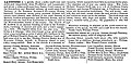 Laysters in Kelly's Directory of Herefordshire 1885 p. 1190.jpg 1,193 × 583; 353 KB
-
 Laysters in Jakeman & Carver's Directory of Herefordshire,1890 pp. 460 - 461.jpg 625 × 1,292; 699 KB
-

-
-

-
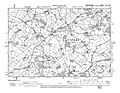 Laysters in Ordnance Survey Second Edition 1905 Sheet XIII. N.W.jpg 1,327 × 1,030; 462 KB
-
 Laysters in Kelly's Directory of Herefordshire 1913 p. 130.jpg 1,210 × 682; 411 KB
-
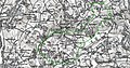
 Laysters in Ordnance Survey SO56 - OS 125,000 map 1956.jpg 1,244 × 903; 1.8 MB
-

-
 A lane, Leysters - geograph.org.uk - 299752.jpg 640 × 480; 60 KB
-
 Avenue Of Trees En Route To Leysters - geograph.org.uk - 1460871.jpg 640 × 480; 286 KB
-
 Avenue Of Trees Near Leysters - geograph.org.uk - 1460875.jpg 640 × 480; 297 KB
-
 Castle mound, Leysters (geograph 7524940).jpg 1,024 × 768; 218 KB
-
 Church House, Leysters (geograph 3402404).jpg 3,089 × 2,047; 1.78 MB
-
 Cinders Lane - geograph.org.uk - 88836.jpg 640 × 480; 52 KB
-
 Cinders Wood. - geograph.org.uk - 88838.jpg 640 × 480; 105 KB
-
 Entrance To Cinders Wood - geograph.org.uk - 1480141.jpg 640 × 480; 284 KB
-
 Farmland near Leysters. - geograph.org.uk - 27035.jpg 640 × 416; 78 KB
-
 Gated Road At Wilden - geograph.org.uk - 1480152.jpg 640 × 480; 281 KB
-
 Gated road, Leysters - geograph.org.uk - 1463138.jpg 640 × 359; 113 KB
-
 Gateway To Cinders - geograph.org.uk - 1480148.jpg 640 × 480; 183 KB
-
 Grassland Near Great Heath - geograph.org.uk - 1460863.jpg 640 × 480; 197 KB
-
 Grassland, Rosedale - geograph.org.uk - 1294156.jpg 640 × 480; 83 KB
-
 Great Heath - geograph.org.uk - 412369.jpg 640 × 426; 146 KB
-
 Lane Approaching Great Heath - geograph.org.uk - 1460867.jpg 640 × 480; 280 KB
-
 Lane At Pound Farm - geograph.org.uk - 1460901.jpg 640 × 480; 183 KB
-
 Lane From The Hundred Meets A4112 - geograph.org.uk - 1460698.jpg 480 × 640; 183 KB
-
 Lane Near Lower Barn - geograph.org.uk - 1480157.jpg 640 × 480; 236 KB
-
 Lane To Cinders - geograph.org.uk - 1480144.jpg 640 × 480; 81 KB
-
 Lane To Leysters - geograph.org.uk - 1460894.jpg 480 × 640; 207 KB
-
 Lane To Pound Farm - geograph.org.uk - 1460878.jpg 480 × 640; 176 KB
-
 Lane To Wilden - geograph.org.uk - 1480149.jpg 640 × 480; 282 KB
-
 Lower Barn - geograph.org.uk - 1480155.jpg 640 × 480; 211 KB
-
 Orchard, Leysters - geograph.org.uk - 299753.jpg 640 × 480; 93 KB
-
 Pond, Great Heath - geograph.org.uk - 1294142.jpg 640 × 480; 169 KB
-
 Pond, Great Heath - geograph.org.uk - 1294149.jpg 640 × 480; 103 KB
-
 Postbox, Rosedale - geograph.org.uk - 1294153.jpg 640 × 480; 140 KB
-
 Potato field, Leysters - geograph.org.uk - 4457764.jpg 800 × 533; 361 KB
-
 Rosedale - geograph.org.uk - 1294161.jpg 640 × 480; 75 KB
-
 Stubble, Woonton - geograph.org.uk - 4213764.jpg 800 × 600; 449 KB
-
 Sunny Bank Dingle - geograph.org.uk - 1463134.jpg 640 × 359; 75 KB
-
 The Avenue - geograph.org.uk - 1291441.jpg 640 × 480; 161 KB
-
 The Avenue, Leysters - geograph.org.uk - 129042.jpg 440 × 640; 98 KB
-
 The Poet's Stone Tribute - geograph.org.uk - 784790.jpg 640 × 480; 74 KB
-
 The Poets Stone - geograph.org.uk - 784783.jpg 640 × 480; 120 KB
-
 Turnips, Leysters - geograph.org.uk - 299750.jpg 640 × 480; 101 KB
-
 Turnips, Leysters - geograph.org.uk - 299751.jpg 640 × 480; 109 KB
-
 Unfenced road - geograph.org.uk - 1463135.jpg 640 × 359; 73 KB
-
 Wilden Hamlet - geograph.org.uk - 1480150.jpg 640 × 480; 86 KB
-
 Woodland by Wilden - geograph.org.uk - 1463146.jpg 640 × 359; 124 KB
-
 Woodland, Leysters - geograph.org.uk - 1294140.jpg 640 × 480; 168 KB
-
 Bridleway To Great Heath - geograph.org.uk - 1460795.jpg 640 × 480; 201 KB
-
 Cinders - geograph.org.uk - 88835.jpg 640 × 384; 36 KB
-
 Grassland, Cinders. - geograph.org.uk - 88837.jpg 637 × 461; 56 KB
-
 Haymaking time - geograph.org.uk - 129513.jpg 640 × 480; 96 KB
-
 Road by Lower Barns' plum orchard - geograph.org.uk - 129523.jpg 640 × 455; 110 KB
-
 The ashbed below Hanging Grove - geograph.org.uk - 129175.jpg 640 × 480; 103 KB
-
 Welcome to Herefordshire - geograph.org.uk - 299757.jpg 640 × 480; 127 KB
-
 Wilden. - geograph.org.uk - 88833.jpg 640 × 480; 48 KB

.jpg)


_-_OS_One-Inch_map_1897_darker.jpg)
_-_OS_One-Inch_map_1897_lighter.jpg)


.jpg)
.jpg)


