Category:Lej da la Tscheppa
Jump to navigation
Jump to search
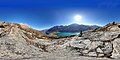
English: Lej da la Tscheppa (1617m) is a mountain lake near Julierpass (Sils im Engadin/Segl, Grisons, Switzerland)
Deutsch: Lej da la Tscheppa (1617m) ist ein Bergsee oberhalb des Julierpass (Sils im Engadin, Graubünden, Schweiz)
Rumantsch: Lej da la Tscheppa (1617m) è en lai alpin sur igl Pass digl Gelgia (Segl, Grischun, Svizra)
| Object location | | View all coordinates using: OpenStreetMap |
|---|
lake above Sils-Maria, in the Engadin valley of the Grisons, Switzerland   | |||||
| Upload media | |||||
| Pronunciation audio | |||||
|---|---|---|---|---|---|
| Instance of | |||||
| Location | Grisons, Switzerland | ||||
| Width |
| ||||
| Length |
| ||||
| Area |
| ||||
| Elevation above sea level |
| ||||
| Basin country | |||||
 | |||||
Media in category "Lej da la Tscheppa"
The following 14 files are in this category, out of 14 total.
-
 2011-08-01 14-54-21 Switzerland Surlej.jpg 4,288 × 2,848; 4.95 MB
-
 Fingerpost near Lej da la Tscheppa.jpg 3,888 × 5,184; 8.89 MB
-
 Lej da la Tscheppa 1.jpg 4,352 × 3,264; 5.17 MB
-
 Lej da la Tscheppa as seen from the hiking path.jpg 4,224 × 1,280; 2.92 MB
-
 Lej da la Tscheppa from north 1.jpg 5,184 × 3,888; 6.02 MB
-
 Lej da la Tscheppa from north 2.jpg 3,984 × 1,280; 2.61 MB
-
 Lej da la Tscheppa from north 3.jpg 5,184 × 3,888; 8.19 MB
-
 Lej da la Tscheppa from south.jpg 3,784 × 1,280; 2.54 MB
-
 Lej da la Tscheppa Spherical Panorama.jpg 21,504 × 10,752; 45.43 MB
-
 Lej da la Tscheppa.jpg 4,352 × 3,264; 4.45 MB
-
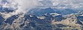
 Muttaun (Piz Polaschin) Spherical Panorama.jpg 20,992 × 10,496; 49.08 MB
-
Roh-putèr-Lej da la Tscheppa.oga 1.8 s; 54 KB
-
 Umgebung Lej da la Tscheppa.jpg 7,172 × 2,615; 4.5 MB
-
 Veduta sopra Silvaplana con un lago alpino.jpg 3,000 × 2,078; 673 KB


_Spherical_Panorama.jpg)
