Category:Llanrhidian Lower
Jump to navigation
Jump to search
community in Swansea, Wales   | |||||
| Upload media | |||||
| Pronunciation audio | |||||
|---|---|---|---|---|---|
| Instance of | |||||
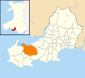
| Location | Swansea, Wales | ||||
| Population |
| ||||
| Area |
| ||||
 | |||||
Subcategories
This category has the following 2 subcategories, out of 2 total.
L
O
Media in category "Llanrhidian Lower"
The following 200 files are in this category, out of 227 total.
(previous page) (next page)-
 2010 Wales Swansea Community Llanrhidian Lower map.svg 512 × 472; 632 KB
-
 2024 Wales Swansea Community Llanrhidian Lower map.svg 512 × 472; 651 KB
-
 A dilemma, over or around^ - geograph.org.uk - 5852907.jpg 3,264 × 2,448; 4.09 MB
-
 A good way out in Llanrhidian Marsh - geograph.org.uk - 2684116.jpg 1,306 × 979; 622 KB
-
 Access to Cilifor Top - geograph.org.uk - 3925919.jpg 640 × 480; 101 KB
-
 Access to Cilifor Top - geograph.org.uk - 3925958.jpg 640 × 480; 95 KB
-
 Access to Cilifor Top - geograph.org.uk - 3925972.jpg 640 × 480; 84 KB
-

-
 Approach to Llethrid Bridge - geograph.org.uk - 5842347.jpg 1,600 × 1,279; 893 KB
-

-
 Approaching Manselfold - geograph.org.uk - 2538020.jpg 640 × 480; 77 KB
-
 Arthur's Stone (Burial Chamber) - geograph.org.uk - 2719444.jpg 4,000 × 3,000; 3.78 MB
-
 Arthur's Stone - Maen Ceti - geograph.org.uk - 3333211.jpg 600 × 450; 98 KB
-
 Arthur's Stone - Maen Ceti - geograph.org.uk - 3333218.jpg 600 × 435; 138 KB
-
 Arthur's Stone - Maen Ceti - geograph.org.uk - 3333220.jpg 600 × 450; 95 KB
-
 Arthur's Stone on Cefn Bryn - geograph.org.uk - 2271705.jpg 3,264 × 2,448; 2.27 MB
-
 Arthur's Stone-Maen Ceti - geograph.org.uk - 5497612.jpg 4,000 × 3,000; 2.49 MB
-
 Arthur’s Stone - geograph.org.uk - 3252725.jpg 2,000 × 1,500; 1.1 MB
-
 At the tide's edge, and nearly dusk - geograph.org.uk - 2684134.jpg 1,306 × 979; 653 KB
-
 B4295 at Aber-Login - geograph.org.uk - 4138244.jpg 640 × 481; 97 KB
-
 B4295 near Wern-halog Farm - geograph.org.uk - 4138243.jpg 640 × 480; 68 KB
-
 B4295 New Road at The Common - geograph.org.uk - 4138241.jpg 640 × 480; 66 KB
-

-
 Barn conversion underway - geograph.org.uk - 3545214.jpg 1,600 × 1,200; 446 KB
-

-
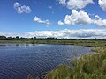
 Broad Pool - geograph.org.uk - 4283450.jpg 640 × 480; 54 KB
-
 Broad Pool - geograph.org.uk - 6188301.jpg 2,048 × 1,536; 1,004 KB
-
 Broad Pool - geograph.org.uk - 6188310.jpg 2,048 × 1,536; 879 KB
-
 Broad Pool from the roadside - geograph.org.uk - 5842325.jpg 4,770 × 2,979; 3.23 MB
-
 Bryngaer Cilifor Hillfort - geograph.org.uk - 4069100.jpg 640 × 480; 87 KB
-
 Cae Ifor Farm on B4295 - geograph.org.uk - 3544809.jpg 1,600 × 1,200; 429 KB
-
 Cairn near Arthur's Stone - geograph.org.uk - 2719446.jpg 4,000 × 3,000; 3.06 MB
-
 Cairn near Arthur’s Stone - geograph.org.uk - 3252705.jpg 2,000 × 1,401; 859 KB
-
 Cattle and sheep grazing - geograph.org.uk - 3545239.jpg 1,600 × 1,200; 319 KB
-
 Cattle grid at Cillibion - geograph.org.uk - 5842333.jpg 1,600 × 1,002; 656 KB
-
 Cattle on common land - geograph.org.uk - 5918800.jpg 3,264 × 2,448; 1.26 MB
-
 Causeway, taken from the castle - geograph.org.uk - 1261258.jpg 640 × 480; 56 KB
-
 Cefn Bryn - geograph.org.uk - 4218047.jpg 640 × 480; 82 KB
-
 Cefn Bryn - geograph.org.uk - 869840.jpg 640 × 362; 137 KB
-
 Cefn Bryn toposcope - geograph.org.uk - 2426241.jpg 640 × 480; 80 KB
-
 Cefn ponies on the moor - geograph.org.uk - 3252764.jpg 2,000 × 1,500; 1.07 MB
-
 Cefn Sidan 12 miles - geograph.org.uk - 6188565.jpg 1,594 × 1,970; 1.09 MB
-
 Churn stand at Eastern Farm - geograph.org.uk - 3543942.jpg 1,600 × 1,200; 507 KB
-
 Cillibion Plantation from Welsh Moor - geograph.org.uk - 1092132.jpg 640 × 480; 122 KB
-
 Coastal Path near Weobly Castle - geograph.org.uk - 2082375.jpg 640 × 640; 428 KB
-
 Coed-y-Dwr - geograph.org.uk - 3545065.jpg 1,600 × 1,200; 395 KB
-
-
 Cotton grass bog - geograph.org.uk - 2427893.jpg 2,048 × 1,536; 684 KB
-
 Crickton Farm - geograph.org.uk - 6277921.jpg 3,264 × 2,448; 2.75 MB
-
 Crossing Llanrhidian Marsh on the causeway - geograph.org.uk - 2687559.jpg 1,306 × 979; 793 KB
-
 Cyclists on Cefn Bryn, Gower - geograph.org.uk - 2426275.jpg 640 × 480; 67 KB
-
 Dam in the water works area - geograph.org.uk - 3252792.jpg 2,000 × 1,488; 1.57 MB
-
 Derelict gunnery range - geograph.org.uk - 3543727.jpg 1,600 × 1,200; 318 KB
-
 Detail of the capstone of Arthur’s Stone - geograph.org.uk - 3252727.jpg 2,000 × 1,500; 1.52 MB
-
 Disused Quarry on Cefn Bryn - geograph.org.uk - 1490174.jpg 640 × 480; 126 KB
-
 Disused quarry on Cefn Bryn - geograph.org.uk - 2719465.jpg 4,000 × 3,000; 3.31 MB
-
 Drainage at Llanrhidian Marsh - geograph.org.uk - 2381213.jpg 1,280 × 960; 567 KB
-
 Drive to a cottage near Penrose Farm - geograph.org.uk - 3987095.jpg 1,024 × 680; 295 KB
-
 Driveway to Llwyn y Bwch - geograph.org.uk - 5922350.jpg 3,264 × 2,448; 1.92 MB
-

-
 Eglwys Llanelen Church - geograph.org.uk - 4094135.jpg 640 × 437; 98 KB
-
 Empty grazing field - geograph.org.uk - 3530077.jpg 1,600 × 1,200; 398 KB
-
 Energy gap - geograph.org.uk - 3545043.jpg 1,600 × 1,200; 609 KB
-
 Estuarine silt - geograph.org.uk - 3543780.jpg 1,600 × 1,200; 612 KB
-
 Fairwood Common - geograph.org.uk - 6188308.jpg 3,264 × 2,448; 5.17 MB
-
 Farm on the edge of Welsh Moor - geograph.org.uk - 5587468.jpg 1,600 × 1,200; 427 KB
-

-
 Ffarm Manselfold Farm - geograph.org.uk - 4238911.jpg 640 × 480; 72 KB
-
 Field and woodland - geograph.org.uk - 5852883.jpg 2,448 × 3,264; 3.64 MB
-
 Fields near Weobley Castle - geograph.org.uk - 1491979.jpg 640 × 455; 95 KB
-
 Fields near Weobley Castle - geograph.org.uk - 1491981.jpg 640 × 455; 97 KB
-
 Filling Station - geograph.org.uk - 5852404.jpg 3,264 × 2,448; 2.76 MB
-
 Filling station and garage, Cillibion - geograph.org.uk - 5842337.jpg 1,600 × 1,067; 665 KB
-

-
 Footpath around Leason wood - geograph.org.uk - 3545266.jpg 1,600 × 1,200; 385 KB
-
 Footpath through the green splendour - geograph.org.uk - 3530094.jpg 1,600 × 1,200; 819 KB
-
 Footpath to Leason - geograph.org.uk - 5852897.jpg 3,264 × 2,448; 2.72 MB
-
 Gated footpath and sycamore tree - geograph.org.uk - 5852892.jpg 2,448 × 3,264; 3.18 MB
-
 Ger - Near Cilibion - geograph.org.uk - 4069080.jpg 640 × 492; 128 KB
-
 Ger - Near Decoy Wood - geograph.org.uk - 4283365.jpg 640 × 480; 119 KB
-
 Ger - near Leason Pill - geograph.org.uk - 4264523.jpg 640 × 480; 44 KB
-
 Ger - Near Lodge Wood - geograph.org.uk - 4283374.jpg 640 × 480; 139 KB
-
 Grass track past Arthur’s Stone - geograph.org.uk - 3252740.jpg 2,000 × 1,500; 1,008 KB
-
 Grassland with sheep and alpacas - geograph.org.uk - 3545049.jpg 3,264 × 2,448; 3.5 MB
-
 Grazing land near Weobley Castle - geograph.org.uk - 2381361.jpg 1,280 × 960; 613 KB
-
 Grazings at Oldwalls - geograph.org.uk - 3544866.jpg 1,600 × 1,200; 350 KB
-
 Green gate - geograph.org.uk - 2384398.jpg 1,280 × 960; 606 KB
-
 Gunnery range buildings slowly return to the sea - geograph.org.uk - 3543745.jpg 1,600 × 1,200; 373 KB
-
 Hay Bales - geograph.org.uk - 5265982.jpg 3,264 × 2,448; 2.46 MB
-
 Heading downhill towards Llanrhidian - geograph.org.uk - 3545290.jpg 1,600 × 1,200; 404 KB
-
 Heol y Morfa - Marsh Road - geograph.org.uk - 4068984.jpg 640 × 480; 67 KB
-
 Hill fort on Cilifor Top - geograph.org.uk - 3987017.jpg 800 × 531; 139 KB
-
 Hill House, Llanrhidian - geograph.org.uk - 4044230.jpg 600 × 400; 73 KB
-
 Hillside and horse above the Loughor estuary - geograph.org.uk - 2719441.jpg 4,000 × 3,000; 3.01 MB
-
 Horses on open land west of Cefn Bryn - geograph.org.uk - 3987078.jpg 1,024 × 680; 291 KB
-
 I hope these sheep can read - geograph.org.uk - 3543850.jpg 3,264 × 2,448; 3.56 MB
-
 Lamb on the marsh - geograph.org.uk - 3543739.jpg 1,600 × 1,200; 272 KB
-
 Landimore Marsh - geograph.org.uk - 977164.jpg 640 × 480; 72 KB
-
 Landward end of the causeway - geograph.org.uk - 2687077.jpg 857 × 1,142; 518 KB
-

-
 Llanrhidian - geograph.org.uk - 868673.jpg 640 × 480; 275 KB
-
 Llanrhidian - geograph.org.uk - 868687.jpg 480 × 640; 250 KB
-
 Llanrhidian - geograph.org.uk - 868725.jpg 480 × 640; 236 KB
-
-
-
 Llanrhidian Marsh - geograph.org.uk - 2687585.jpg 1,306 × 979; 806 KB
-
 Llanrhidian Marsh - geograph.org.uk - 5853032.jpg 3,156 × 2,366; 3.04 MB
-
 Llanrhidian Salt Marsh SS4993 - geograph.org.uk - 1092105.jpg 640 × 493; 183 KB
-
 Llanrhidian Sands - geograph.org.uk - 2882554.jpg 1,600 × 1,200; 264 KB
-
 Llethryd Barns - geograph.org.uk - 5265980.jpg 3,264 × 2,448; 2.54 MB
-
 Llwybr Arfordir Cymru - geograph.org.uk - 3545307.jpg 1,600 × 1,200; 548 KB
-
 Llwybr Arfordir Cymru - geograph.org.uk - 3545327.jpg 1,600 × 1,200; 603 KB
-
 Llwybr Ceffyl Welsh Moor Bridleway - geograph.org.uk - 4069071.jpg 640 × 480; 142 KB
-
 Llwybr Cillibion Path - geograph.org.uk - 4347843.jpg 640 × 480; 129 KB
-
 Llwybr Llanelen - Llanelen path - geograph.org.uk - 4089859.jpg 640 × 437; 56 KB
-
 Llwybr Oldwalls - Oldwalls Path - geograph.org.uk - 4254175.jpg 640 × 480; 141 KB
-
 Local electricity sub-station - geograph.org.uk - 3544871.jpg 1,600 × 1,200; 481 KB
-
 Looking back towards the buildings at Leason - geograph.org.uk - 3545283.jpg 1,600 × 1,200; 553 KB
-
 Looking inland along a flooding pill - geograph.org.uk - 2687609.jpg 1,306 × 979; 623 KB
-
 Looking northwards on Llanrhidian Marsh - geograph.org.uk - 2684121.jpg 1,306 × 979; 738 KB
-
 Looking To Llanrhidian Pill - geograph.org.uk - 4537903.jpg 1,600 × 1,067; 245 KB
-
 Looking westwards on a flooding pill - geograph.org.uk - 2684126.jpg 1,306 × 979; 625 KB
-
 Loughor Estuary from Cilifor Top - geograph.org.uk - 3925941.jpg 640 × 330; 25 KB
-

-

-
 Maenhir Samson Jack Standing Stone - geograph.org.uk - 4092076.jpg 640 × 417; 102 KB
-
 Manure pile near Cilifor Top - geograph.org.uk - 5587464.jpg 1,600 × 1,200; 438 KB
-
 Milestone - Swansea 11 - geograph.org.uk - 4454595.jpg 480 × 640; 118 KB
-
 Milk Churn - geograph.org.uk - 5265976.jpg 2,448 × 3,264; 2.85 MB
-
-
 Moorland pond - geograph.org.uk - 3252694.jpg 2,000 × 1,500; 936 KB
-

-

-

-
 New Road leaving Llanrhidian - geograph.org.uk - 4138240.jpg 640 × 480; 64 KB
-
 North Gower Hotel - geograph.org.uk - 2427887.jpg 2,048 × 1,536; 612 KB
-
 Old churn stand - geograph.org.uk - 3543935.jpg 3,264 × 2,448; 3.75 MB
-
 Old red sandstone in a quarry on Cefn Bryn - geograph.org.uk - 3252688.jpg 2,000 × 1,500; 1.17 MB
-
 Oldwalls Lane at Stembridge Farm - geograph.org.uk - 4138231.jpg 640 × 481; 72 KB
-
 Open marginal grazing - geograph.org.uk - 3530137.jpg 1,600 × 1,200; 336 KB
-
 Ordnance Survey Cut Mark - geograph.org.uk - 4511927.jpg 480 × 640; 83 KB
-
 Ordnance Survey Flush Bracket (S1173) - geograph.org.uk - 4017107.jpg 480 × 640; 112 KB
-
 Park Woods - geograph.org.uk - 2084827.jpg 1,600 × 1,229; 831 KB
-
 Part of Weobley Castle, Gower - geograph.org.uk - 2538010.jpg 640 × 480; 101 KB
-
 Peat with cotton grass and rushes - geograph.org.uk - 3530100.jpg 3,264 × 2,448; 3.93 MB
-
 Petrol station and Post Office - geograph.org.uk - 5587024.jpg 1,600 × 1,200; 353 KB
-
 Petrol Station at Llanrhidian - geograph.org.uk - 4579285.jpg 640 × 428; 48 KB
-
 Ponies grazing near Leason Wood - geograph.org.uk - 3545276.jpg 1,600 × 1,200; 640 KB
-
 Pony foal on Cefn Bryn - geograph.org.uk - 1820711.jpg 640 × 480; 128 KB
-
 Rainbow, seen from the water works - geograph.org.uk - 3252802.jpg 2,000 × 1,473; 733 KB
-
 Re-cycled letter box - geograph.org.uk - 3545076.jpg 1,600 × 1,200; 624 KB
-
 Reed bed - geograph.org.uk - 5852960.jpg 3,264 × 2,448; 3.23 MB
-
 Reed bed - geograph.org.uk - 5853019.jpg 3,264 × 2,448; 3.75 MB
-
 Reynoldston Trig - geograph.org.uk - 3297224.jpg 1,572 × 1,162; 949 KB
-
 Rhos Welsh Moor - geograph.org.uk - 4347686.jpg 640 × 480; 79 KB
-
 Rifle range on Llanrhidian Marsh - geograph.org.uk - 5586974.jpg 1,600 × 1,200; 406 KB
-

-
 Road crossing Welsh Moor - geograph.org.uk - 3987002.jpg 800 × 531; 119 KB
-
 Road junction - geograph.org.uk - 5853026.jpg 3,264 × 2,448; 2 MB
-
 Road junction near The Greyhound Inn - geograph.org.uk - 3545094.jpg 1,600 × 1,200; 309 KB
-
 Road on Cefn Bryn, Gower - geograph.org.uk - 2417229.jpg 640 × 480; 65 KB
-
 Road sign at junction - geograph.org.uk - 1035775.jpg 640 × 480; 55 KB
-
 Road to Welsh Moor - geograph.org.uk - 3987058.jpg 1,024 × 680; 252 KB
-
 Roadside grazing with ponies - geograph.org.uk - 3545013.jpg 1,600 × 1,200; 428 KB
-
 Rural house on road junction - geograph.org.uk - 3545227.jpg 1,600 × 1,200; 315 KB
-
 Samson's Jack standing stone on Gower - geograph.org.uk - 2538017.jpg 640 × 480; 110 KB
-

-
 Scrubby bushes on moorland on Cefn Bryn - geograph.org.uk - 5842314.jpg 1,600 × 725; 472 KB
-
 Sheep pasture south of the B4271 - geograph.org.uk - 1042577.jpg 640 × 480; 119 KB
-
 Silver Jubilee commemoration - geograph.org.uk - 6188520.jpg 1,536 × 2,048; 1.16 MB
-
 Southwards along the tidal pill - geograph.org.uk - 2684128.jpg 1,306 × 979; 594 KB
-
 Springtime verge near Llanrhidian - geograph.org.uk - 3987035.jpg 1,024 × 680; 352 KB
-
 Staffal Haegr - geograph.org.uk - 3545342.jpg 1,600 × 1,200; 461 KB
-
 Stavel Hagar Mill - geograph.org.uk - 5852913.jpg 3,264 × 2,448; 3.77 MB
-
 Sticil Stoneyford stile, Llanrhidian - geograph.org.uk - 3038368.jpg 690 × 518; 163 KB
-
 Stile on ancient footpath - geograph.org.uk - 3543906.jpg 3,258 × 2,440; 4.08 MB
-
 Swansea Wales communities - Llanrhidian Lower locator.png 790 × 760; 87 KB
-
 The 'obs' post on Llanrhidian Marsh - geograph.org.uk - 2684110.jpg 1,306 × 979; 638 KB
-
 The American lookout post - geograph.org.uk - 2687597.jpg 979 × 1,306; 606 KB
-
 The B4271 near Parkmill - geograph.org.uk - 3987103.jpg 1,024 × 680; 273 KB
-
 The bend in the road - geograph.org.uk - 3252811.jpg 2,000 × 1,459; 1 MB
-
 The bottom end of the water works - geograph.org.uk - 3252819.jpg 2,000 × 1,500; 1.24 MB
-
 The entrance to Weobley Castle - geograph.org.uk - 2538001.jpg 640 × 480; 81 KB
-
 The Gower Way on Cefn Bryn - geograph.org.uk - 5762386.jpg 3,776 × 2,520; 2.82 MB
-
 The interior of Weobley Castle courtyard - geograph.org.uk - 2538012.jpg 640 × 480; 106 KB
-
 The road east across Cefn Bryn - geograph.org.uk - 5842288.jpg 1,600 × 797; 458 KB
-
 This was a minimum requirement building - geograph.org.uk - 3543765.jpg 3,264 × 2,448; 3.61 MB
-
 Through the bracken and into the trees - geograph.org.uk - 3545295.jpg 1,600 × 1,200; 728 KB
-
 Tidal drain across the salting - geograph.org.uk - 3543820.jpg 1,600 × 1,200; 303 KB
-
 Tidal drain looking east - geograph.org.uk - 3543839.jpg 1,600 × 1,200; 267 KB
-
 Track across the salting - geograph.org.uk - 3543794.jpg 1,600 × 1,200; 324 KB
-
 Track heading south - geograph.org.uk - 3530067.jpg 1,600 × 1,200; 802 KB
-
 Track near Little Cillibion - geograph.org.uk - 3987084.jpg 1,024 × 680; 329 KB
-
 Track north of the B4271 - geograph.org.uk - 1053968.jpg 640 × 499; 99 KB
-

-

-
 Triangulation pillar on the Cefn Bryn ridge - geograph.org.uk - 3252323.jpg 2,000 × 1,500; 1.05 MB
-
 Trig Point on Cilifor Top - geograph.org.uk - 3926013.jpg 640 × 480; 69 KB
-
 Trig Point on Cilifor Top - geograph.org.uk - 3926018.jpg 640 × 480; 61 KB
-
 Tuag at - Towards Broad Pool - geograph.org.uk - 4283421.jpg 640 × 480; 69 KB


_-_geograph.org.uk_-_2719444.jpg)


_-_geograph.org.uk_-_4017107.jpg)


