Category:Locator maps of counties of Wisconsin
Jump to navigation
Jump to search

States of the United States: Alabama · Alaska · Arizona · Arkansas · California · Colorado · Connecticut · Delaware · Florida · Georgia · Hawaii · Idaho · Illinois · Indiana · Iowa · Kansas · Kentucky · Louisiana · Maine · Maryland · Massachusetts · Michigan · Minnesota · Mississippi · Missouri · Montana · Nebraska · Nevada · New Hampshire · New Jersey · New Mexico · New York · North Carolina · North Dakota · Ohio · Oklahoma · Oregon · Pennsylvania · Rhode Island · South Carolina · South Dakota · Tennessee · Texas · Utah · Vermont · Virginia · Washington · West Virginia · Wisconsin · Wyoming
| NO WIKIDATA ID FOUND! Search for Locator maps of counties of Wisconsin on Wikidata | |
| Upload media |
English: Locator maps for counties in Wisconsin.
Media in category "Locator maps of counties of Wisconsin"
The following 78 files are in this category, out of 78 total.
-
 Map of Wisconsin highlighting Adams County.svg 4,747 × 5,087; 103 KB
-
 Map of Wisconsin highlighting Ashland County.svg 4,747 × 5,087; 103 KB
-
 Map of Wisconsin highlighting Barron County.svg 4,747 × 5,087; 103 KB
-
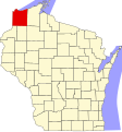
 Map of Wisconsin highlighting Bayfield County.svg 4,747 × 5,087; 103 KB
-
 Map of Wisconsin highlighting Brown County.svg 4,747 × 5,087; 103 KB
-
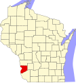
 Map of Wisconsin highlighting Buffalo County.png 286 × 300; 19 KB
-
 Map of Wisconsin highlighting Buffalo County.svg 4,747 × 5,087; 103 KB
-
 Map of Wisconsin highlighting Burnett County.svg 4,747 × 5,087; 103 KB
-
 Map of Wisconsin highlighting Calumet County.svg 4,747 × 5,087; 103 KB
-
 Map of Wisconsin highlighting Chippewa County.svg 4,747 × 5,087; 103 KB
-
 Map of Wisconsin highlighting Clark County.png 286 × 300; 17 KB
-
 Map of Wisconsin highlighting Clark County.svg 4,747 × 5,087; 103 KB
-
 Map of Wisconsin highlighting Columbia County.svg 4,747 × 5,087; 103 KB
-
 Map of Wisconsin highlighting Crawford County.svg 4,747 × 5,087; 103 KB
-
 Map of Wisconsin highlighting Dane County.svg 4,747 × 5,087; 103 KB
-
 Map of Wisconsin highlighting Dodge County.svg 4,747 × 5,087; 103 KB
-
 Map of Wisconsin highlighting Door County.svg 4,747 × 5,087; 103 KB
-
 Map of Wisconsin highlighting Douglas County.svg 4,747 × 5,087; 103 KB
-
 Map of Wisconsin highlighting Dunn County.svg 4,747 × 5,087; 103 KB
-
 Map of Wisconsin highlighting Eau Claire County.svg 4,747 × 5,087; 103 KB
-
 Map of Wisconsin highlighting Florence County.svg 4,747 × 5,087; 103 KB
-
 Map of Wisconsin highlighting Fond du Lac County.svg 4,747 × 5,087; 103 KB
-
 Map of Wisconsin highlighting Forest County.svg 4,747 × 5,087; 103 KB
-
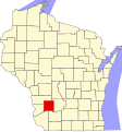
 Map of Wisconsin highlighting Grant County.svg 4,747 × 5,087; 103 KB
-
 Map of Wisconsin highlighting Green County.svg 4,747 × 5,087; 103 KB
-
 Map of Wisconsin highlighting Green Lake County.svg 4,747 × 5,087; 103 KB
-
 Map of Wisconsin highlighting Iowa County.svg 4,747 × 5,087; 103 KB
-
 Map of Wisconsin highlighting Iron County.svg 4,747 × 5,087; 103 KB
-
 Map of Wisconsin highlighting Jackson County.png 286 × 300; 20 KB
-
 Map of Wisconsin highlighting Jackson County.svg 4,747 × 5,087; 103 KB
-
 Map of Wisconsin highlighting Jefferson County.svg 4,747 × 5,087; 103 KB
-
 Map of Wisconsin highlighting Juneau County.svg 4,747 × 5,087; 103 KB
-
 Map of Wisconsin highlighting Kenosha County.svg 4,747 × 5,087; 103 KB
-
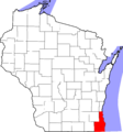
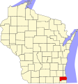
 Map of Wisconsin highlighting Kewaunee County.svg 4,747 × 5,087; 103 KB
-
 Map of Wisconsin highlighting La Crosse County.svg 4,747 × 5,087; 103 KB
-
 Map of Wisconsin highlighting Lafayette County.svg 4,747 × 5,087; 103 KB
-
 Map of Wisconsin highlighting Langlade County.svg 4,747 × 5,087; 103 KB
-
 Map of Wisconsin highlighting Lincoln County.svg 4,747 × 5,087; 103 KB
-
 Map of Wisconsin highlighting Manitowoc County.svg 4,747 × 5,087; 103 KB
-
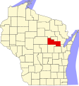
 Map of Wisconsin highlighting Marathon County.svg 4,747 × 5,087; 103 KB
-
 Map of Wisconsin highlighting Marinette County.svg 4,747 × 5,087; 103 KB
-
 Map of Wisconsin highlighting Marquette County.svg 4,747 × 5,087; 103 KB
-
 Map of Wisconsin highlighting Menominee County.svg 4,747 × 5,087; 103 KB
-
 Map of Wisconsin highlighting Milwaukee County.svg 4,747 × 5,087; 103 KB
-
 Map of Wisconsin highlighting Milwaukee Racine Kenosha Counties.png 2,374 × 2,544; 339 KB
-
 Map of Wisconsin highlighting Monroe County.svg 4,747 × 5,087; 103 KB
-
 Map of Wisconsin highlighting Oconto County.svg 4,747 × 5,087; 103 KB
-
 Map of Wisconsin highlighting Oneida County.svg 4,747 × 5,087; 103 KB
-
 Map of Wisconsin highlighting Outagamie County.svg 4,747 × 5,087; 103 KB
-
 Map of Wisconsin highlighting Ozaukee County.svg 4,747 × 5,087; 103 KB
-
 Map of Wisconsin highlighting Pepin County.svg 4,747 × 5,087; 103 KB
-
 Map of Wisconsin highlighting Pierce County.svg 4,747 × 5,087; 103 KB
-
 Map of Wisconsin highlighting Polk County.svg 4,747 × 5,087; 103 KB
-
 Map of Wisconsin highlighting Portage County.png 286 × 300; 17 KB
-
 Map of Wisconsin highlighting Portage County.svg 4,747 × 5,087; 103 KB
-
 Map of Wisconsin highlighting Price County.svg 4,747 × 5,087; 103 KB
-
 Map of Wisconsin highlighting Racine County.svg 4,747 × 5,087; 103 KB
-
 Map of Wisconsin highlighting Richland County.svg 4,747 × 5,087; 103 KB
-
 Map of Wisconsin highlighting Rock County.svg 4,747 × 5,087; 103 KB
-
 Map of Wisconsin highlighting Rusk County.svg 4,747 × 5,087; 103 KB
-
 Map of Wisconsin highlighting Saint Croix County.svg 4,747 × 5,087; 103 KB
-
 Map of Wisconsin highlighting Sauk County.svg 4,747 × 5,087; 103 KB
-
 Map of Wisconsin highlighting Sawyer County.svg 4,747 × 5,087; 103 KB
-
 Map of Wisconsin highlighting Shawano County.svg 4,747 × 5,087; 103 KB
-
 Map of Wisconsin highlighting Sheboygan County.svg 4,747 × 5,087; 103 KB
-
 Map of Wisconsin highlighting Taylor County.svg 4,747 × 5,087; 103 KB
-
 Map of Wisconsin highlighting the Milwaukee-Racine-Waukesha CSA.svg 4,747 × 5,087; 103 KB
-
 Map of Wisconsin highlighting Trempealeau County.svg 4,747 × 5,087; 103 KB
-
 Map of Wisconsin highlighting Vernon County.svg 4,747 × 5,087; 103 KB
-
 Map of Wisconsin highlighting Vilas County.svg 4,747 × 5,087; 103 KB
-
 Map of Wisconsin highlighting Walworth County.svg 4,747 × 5,087; 103 KB
-
 Map of Wisconsin highlighting Washburn County.svg 4,747 × 5,087; 103 KB
-
 Map of Wisconsin highlighting Washington County.svg 4,747 × 5,087; 103 KB
-
 Map of Wisconsin highlighting Waukesha County.svg 4,747 × 5,087; 103 KB
-
 Map of Wisconsin highlighting Waupaca County.svg 4,747 × 5,087; 103 KB
-
 Map of Wisconsin highlighting Waushara County.svg 4,747 × 5,087; 103 KB
-
 Map of Wisconsin highlighting Winnebago County.svg 4,747 × 5,087; 103 KB
-
 Map of Wisconsin highlighting Wood County.svg 4,747 × 5,087; 103 KB


