Category:London to Aylesbury Line
Appearance
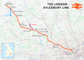
The London to Aylesbury Line links London with Aylesbury in Buckinghamshire.
railway line in the UK | |||||
Upload media | |||||
Instance of | |||||
---|---|---|---|---|---|
Location |
| ||||
Has part(s) |
| ||||
Date of official opening |
| ||||
Terminus | |||||
Train depot | |||||
| |||||
![]() |
Subcategories
This category has the following 11 subcategories, out of 11 total.
Media in category "London to Aylesbury Line"
The following 72 files are in this category, out of 72 total.
-
London–Aylesbury line.png 2,357 × 1,686; 3.52 MB
-
Amersham MMB 01 Metropolitan Line.jpg 3,614 × 2,513; 3.27 MB
-
Aylesbury to London Marylebone railway - geograph.org.uk - 183011.jpg 640 × 480; 117 KB
-
Blackhorse Bridge - geograph.org.uk - 3916989.jpg 1,024 × 768; 117 KB
-
Foot crossing over railway - geograph.org.uk - 3129782.jpg 4,000 × 3,000; 2.64 MB
-
Footbridge over railway - geograph.org.uk - 3129763.jpg 4,000 × 3,000; 2.2 MB
-
Footpath crossing the tracks - geograph.org.uk - 5117611.jpg 1,600 × 1,200; 745 KB
-
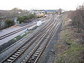
Heading away from Wendover - geograph.org.uk - 1055352.jpg 640 × 480; 91 KB
-
Line heading to Great Missenden - geograph.org.uk - 1054421.jpg 640 × 480; 113 KB
-
Lodge Lane - geograph.org.uk - 1065177.jpg 640 × 480; 110 KB
-
London to Aylesbury Line.png 901 × 648; 37 KB
-
Looking south from Moor Park station - geograph.org.uk - 5855986.jpg 4,000 × 3,000; 4.58 MB
-
Low and Narrow - geograph.org.uk - 6450016.jpg 685 × 1,024; 143 KB
-
Metropolitan and GC Joint Line - geograph.org.uk - 4176913.jpg 640 × 480; 156 KB
-
Metropolitan Line - geograph.org.uk - 1052090.jpg 640 × 480; 132 KB
-
Metropolitan Line bridge MR103 - geograph.org.uk - 4142571.jpg 640 × 480; 171 KB
-
Metropolitan Line bridge MR60 - geograph.org.uk - 4330868.jpg 640 × 480; 153 KB
-
Metropolitan Line bridge MR68 - geograph.org.uk - 4323062.jpg 640 × 480; 144 KB
-
Metropolitan Line bridge MR69 - geograph.org.uk - 4323045.jpg 640 × 480; 155 KB
-
Metropolitan Line bridge, Moor Park - geograph.org.uk - 4366372.jpg 4,320 × 3,240; 4.36 MB
-
Metropolitan Line railway at Northwood - geograph.org.uk - 83694.jpg 640 × 480; 116 KB
-
Metropolitan Line railway near Chorleywood - geograph.org.uk - 95884.jpg 640 × 480; 163 KB
-
Nag's Head Lane passes under the railway - geograph.org.uk - 4104432.jpg 3,007 × 2,707; 1.85 MB
-
Neasden South Junction Geograph 725944.jpg 640 × 480; 108 KB
-
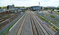
Northwick Park station MMB 01.jpg 3,903 × 2,505; 3.3 MB
-
Rail lines from Dudden Hill Lane - geograph.org.uk - 574791.jpg 640 × 480; 123 KB
-
Railway bridge in Great Missenden - geograph.org.uk - 5653230.jpg 640 × 480; 95 KB
-
Railway bridge over A413 - geograph.org.uk - 6178813.jpg 1,024 × 684; 305 KB
-
Railway bridge over Chalk Lane - geograph.org.uk - 4425155.jpg 2,592 × 1,944; 2.38 MB
-
Railway bridge over Station Road - geograph.org.uk - 1395571.jpg 640 × 480; 98 KB
-
Railway bridge over the A413, Great Missenden - geograph.org.uk - 2632503.jpg 1,594 × 1,049; 570 KB
-
Railway Bridge, A4154 - geograph.org.uk - 6421974.jpg 1,024 × 684; 181 KB
-
Railway Bridge, Berry Lane - geograph.org.uk - 3330504.jpg 640 × 430; 59 KB
-
Railway bridge, Berry Lane - geograph.org.uk - 3330531.jpg 640 × 430; 104 KB
-
Railway Bridge, Berry Lane - geograph.org.uk - 6433522.jpg 1,024 × 685; 215 KB
-
Railway bridge, Chapel Lane, Pinner - geograph.org.uk - 4856566.jpg 1,024 × 768; 138 KB
-
Railway bridge, Little Kingshill - geograph.org.uk - 147211.jpg 640 × 480; 126 KB
-
Railway Bridge, Moor Park - geograph.org.uk - 6449965.jpg 1,024 × 684; 310 KB
-
Railway bridge, Station Road, Rickmansworth - geograph.org.uk - 6444187.jpg 1,024 × 768; 408 KB
-
Railway Bridge, Westbury Rd - geograph.org.uk - 6450020.jpg 1,024 × 684; 175 KB
-
Railway line to Quainton Road Station 1 - geograph.org.uk - 1048292.jpg 640 × 480; 108 KB
-
Railway lines south of Walm Lane, Willesden Green - geograph.org.uk - 2248391.jpg 1,600 × 1,200; 877 KB
-
Railway lines, Harrow on the Hill - geograph.org.uk - 2280112.jpg 1,600 × 1,200; 582 KB
-
Railway, Little Missenden - geograph.org.uk - 150405.jpg 640 × 480; 130 KB
-
Station Road runs under a railway bridge in Amersham - geograph.org.uk - 6618099.jpg 4,800 × 3,600; 1.37 MB
-
The old Metropolitan Railway in Hyde Heath - geograph.org.uk - 5738012.jpg 2,304 × 1,728; 2.17 MB
-
Towards Stoke Mandeville Station - geograph.org.uk - 5117612.jpg 1,600 × 1,200; 615 KB
-
Tracks west of Harrow-on-the-Hill station - geograph.org.uk - 4728395.jpg 4,608 × 3,456; 3.45 MB
-
Underground train near Chorleywood - geograph.org.uk - 3330530.jpg 640 × 430; 100 KB