Category:Loring Hall
Jump to navigation
Jump to search
This is a category about listed building number 1359399. |
| Object location | | View all coordinates using: OpenStreetMap |
|---|
country house convertd into hospital building in London, England, UK .jpg) | |||||
| Upload media | |||||
| Instance of |
| ||||
|---|---|---|---|---|---|
| Location | North Cray, London Borough of Bexley, Greater London, London, England | ||||
| Heritage designation |
| ||||
 | |||||
Subcategories
This category has only the following subcategory.
Media in category "Loring Hall"
The following 9 files are in this category, out of 9 total.
-
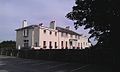 Castlereagh's House.jpg 640 × 384; 69 KB
-
 Loring Hall (geograph 2841743).jpg 640 × 428; 77 KB
-
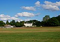
 Loring Hall in landscape perspective.jpg 4,896 × 3,264; 7.5 MB
-
 Loring Hall, North Cray (Southeast View - 01).jpg 4,265 × 2,827; 6.68 MB
-
 Post Box on the Wall of Loring Hall.jpg 3,160 × 4,457; 15.23 MB
-
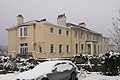
 Side of Loring Hall.JPG 4,522 × 2,973; 6.02 MB
-
 Southeast Side of Loring Hall.jpg 3,750 × 2,616; 9.33 MB
-
 VISCOUNT CASTLEREAGH - Loring Hall 8 Water Lane North Cray Sidcup DA14 5ES.jpg 2,000 × 1,500; 1.2 MB
-
 Western Side of Loring Hall.jpg 4,389 × 3,103; 11.92 MB


.jpg)


